Friday, June 10, 2011

Summer 2011 Heat Records Crushing Cold Records by 13 to 1

For related record temperature posts, see: After narrowly exceeding cold records in May, U.S. heat records in the first 9 days of June have outnumbered cold records by an eye-popping ratio of 13 to 1. For the year 2011 to date, the ratio is a more modest, but still impressive, 2.2 to 1. The cumulative excess of heat records over cold records since January 2010 is over 10,000. Since March 2010 there has been only 1 month (December) with more low temperature records than high temperature records.

Although June temperatures to date have been particularly cold in California, they have been warmer than average nearly everywhere east of the Rockies.

Images (click to enlarge):
  • Monthly total number of daily high temperature and low temperature records set in the U.S. for June 2010 through June 9, 2011, data from NOAA National Climatic Data Center, background image © Kevin Ambrose (www.weatherbook.com). Includes historical daily observations archived in NCDC's Cooperative Summary of the Day data set and preliminary reports from Cooperative Observers and First Order National Weather Service stations. All stations have a Period of Record of at least 30 years.
  • Cumulative excess of heat records vs. cold records by month for 2010 and 2011 to date, data source as above
  • Preliminary June 2011 to date monthly temperature departure from climatological average from NOAA/NCEP via ESRL

Steaming Toad Settles Some Science

May I have some more CO2, please?

Thursday, June 9, 2011

Washington Ties All-Time June Heat Record; More Early Summer Heat Records From NC to NY

Image (click to enlarge): U.S. surface temperatures at 3 pm EDT, June 9, 2011, from Unisys

As noted earlier, the high temperature at Washington of 102° tied both the record for the date and the all-time June record. In addition to the records listed earlier, here are some other temperature records for June 9 (old record in parentheses):
Elizabeth City NC  98 (96, 1993)
Richmond VA 98 (tie, 2008/1999)
Wallops Island VA 99 (94, 1999)
Salisbury MD 100 (97, 1999)
Atlantic City NJ 102 (98, 2008)
Georgetown DE 97 (tie, 2008)
Wilmington DE 97 (96, 1984)
Philadelphia PA 99 (98, 1933)
Reading PA 98 (tie, 1933)
Binghamton NY 89 (tie, 2008)

Record Mid-Atlantic Heat Continues: Baltimore Ties Record by 1 PM;
Update: Baltimore Hits 100°, Earliest Ever in Atlantic City, DC Ties

5 PM Update: Newark raised its record temperature to 102°, beating the old record by 3°.

4:10 PM Update: The National Weather Service reports that Washington hit 102° between hours, tying the all-time June record set in 1874.

Washington Dulles has also broken its record with 97°, exceeding the 96° in 1999.

4 PM Update: Washington's temperature is 101° at 4 pm, 1° below the record for the date and the all-time June record. This is also tied for the second earliest 100° or higher. The earliest was on June 5, 1925.

2:30 PM Update: The heat is particularly intense in New Jersey. The National Weather Service reports that Atlantic City NJ has already blasted away its old record of 98° from 2008 with a reading of 101°. This is also the earliest 100° temperature by almost 2 weeks, surpassing the old record on June 22, 1988.

The 101° at Newark NJ breaks the old record of 99° in 2008.

Toms River NJ is also at 100°.

2 PM Update: Baltimore has hit 100° between hours to break the record. This is the second earliest 100° temperature at Baltimore. The earliest was 101° on June 5, 1925.

Downtown Baltimore is 102°. Washington has reached 99°. Frederick MD is still at 100°. Salisbury MD, Culpeper VA, and College Park MD are all 99°.

Original post:
The record Mid Atlantic early summer heat wave continues today. As of 1 pm, Baltimore has already tied its June 9 record high temperature of 98°, last reported in 1933. The 98° at Washington National is still short of the record of 102°, which is also the all-time June record high. Washington Dulles is at 95°, just below the record 96° in 1999.

Frederick MD and downtown Baltimore are both at 100°.

Climate Consequences: Chicago Corn Crunch


Image (click to enlarge): U.S. statewide precipitation ranks for May 2011, showing above normal to much-above normal amounts in the major corn-producing region, from National Climatic Data Center

Climate has consequences. Persistently heavy rain and flooding in the Midwest this spring has led the USDA to report today that the number of acres planted as well as harvested is expected to decrease below earlier estimates. This has resulted in Chicago corn prices reaching an all-time record high at the opening this morning (click image to play CNBC video):

Wednesday, June 8, 2011

Summer's Scorching Start: Heat Records Outnumber Cold Records by 10:1;
Update: New Records in Washington, Baltimore, Philadelphia, Syracuse

5:30 PM Update: The high temperatures of 99° at both Washington National and Baltimore are new records. The high at Washington Dulles of 96° missed by 1 degree.

Other records set or tied (old record in parentheses):
Reading PA        96 (95, 2005)
Atlantic City NJ 98 (tie, 1999)
Allentown PA 96 (94, 1984)
Mt. Pocono PA 91 (88, 1999)
Philadelphia PA 97 (95, 2008)
Syracuse NY 97 (94, 2005)
Binghamton NY 91 (89, 2005)
Erie PA 92 (91, 2007/1933)
Newark NJ 99 (97, 1999/1984)
Albany NY 93 (tie, 1984)
Burlington VT 91 (tie, 2008/1984)
Watertown NY 91 (90, 2007)
The Central Park NY high of 94° missed the 1933 record by 1 degree.

Original post:
After crushing heat records in the Midwest yesterday, soaring temperatures have now moved eastward. The 98° at both 3 pm and 4 pm EDT in Washington at least ties the record for June 8 set in 1999, and the 98° in Baltimore (BWI) breaks the record of 97°, also from 1999.

For the first week of meteorological summer (June-August), new high temperature records (1,208) have outnumbered low temperature records (115) in the U.S. by over 10:1.

Image (click to enlarge): Month-to-date average temperatures and departures from normal for June 2011

Tuesday, June 7, 2011

Minnesota, Wisconsin Heat Records Roasted;
Update: Minneapolis Warmest Minimum Broken by 7°

Image (click to enlarge): Surface temperatures at 5 pm CDT, June 7, 2011, from Unisys; Minnesota/Wisconsin high temperatures for June 7, from National Weather Service

Midnight CDT Update: With one hour left to go in June 7 (local standard time), the temperature is currently 86° at Minneapolis. The morning low of 78° beats the old warmest minimum for June 7, set in 1959, by 7°. Today's low temperature is equal to the average high temperature for June 7.

9 PM CDT Update: The hottest day in Minneapolis since 1988 snarled rush hour traffic as buckled pavement closed 3 lanes of Interstate 94.

8 PM CDT Update: Some more Minnesota/Wisconsin/Iowa high temperature records smashed on June 7:
A RECORD HIGH TEMPERATURE OF 100 DEGREES WAS SET AT EAU CLAIRE WI   
TODAY AT 456 PM CDT. THIS BREAKS THE OLD RECORD OF 95 SET IN 1987.

A RECORD HIGH TEMPERATURE OF 100 DEGREES WAS SET AT LA CROSSE WI
TODAY. THIS BREAKS THE OLD RECORD OF 97 SET IN 1987.

A RECORD HIGH TEMPERATURE OF 101 DEGREES WAS SET AT ST CLOUD MN
TODAY AT 233 PM CDT. THIS BREAKS THE OLD RECORD OF 96 SET IN 2004.

A RECORD HIGH TEMPERATURE OF 101 DEGREES WAS SET AT ROCHESTER MN
TODAY. THIS BREAKS THE OLD RECORD OF 95 SET IN 1987.

THE TEMPERATURE AT THE SIOUX CITY GATEWAY AIRPORT [Iowa] ROSE TO 99 DEGREES
AT 254 PM THIS AFTERNOON...WHICH ESTABLISHES A NEW RECORD DAILY HIGH
TEMPERATURE FOR THIS DATE.
THE PREVIOUS RECORD WAS 96 DEGREES...WHICH WAS SET IN 1981...1987
AND IN 2000.

A RECORD HIGH TEMPERATURE OF 99 DEGREES WAS SET AT MASON CITY IA
TODAY. THIS BREAKS THE OLD RECORD OF 95 SET IN 1987.
Original post:
It's only the first week of meteorological summer (June-August), but high temperature records are falling by wide margins in Minnesota and southern Wisconsin.

The 103° at Minneapolis as of 3:26 pm CDT smashed the old record for June 7 in 2004 by 8°. This was also just 1° below the all-time June record of 104° set on June 27th, 1934. The National Weather Service also reports that this was:
  • The first 100°+ reading since July 31, 2006.
  • The first 103°+ reading in almost 23 years, since July 31, 1988.
  • The second earliest on record that 103° had occurred, only behind May 31, 1934.
Today's record high follows a record high yesterday (June 6) of 97°, beating the old high of 95° in both 1987 and 1979.

Other records set for June 7:
A RECORD HIGH TEMPERATURE OF 99 DEGREES WAS SET AT EAU CLAIRE WI   
TODAY AT 254 PM CDT. THIS BREAKS THE OLD RECORD OF 95 SET IN 1987.

A RECORD HIGH TEMPERATURE OF 101 DEGREES WAS SET AT ST CLOUD MN
TODAY AT 233 PM CDT. THIS BREAKS THE OLD RECORD OF 96 SET IN 2004.
Today's highs are in the top 5 highest in a decade at Milwaukee and Madison, Wisconsin. The National Weather service reports that, as of 5 pm CDT, both locations had broken long-standing record high temperatures for the date:
RECORD HIGH TEMPERATURES HAVE BEEN SET SO FAR IN MADISON AND
MILWAUKEE (TUESDAY JUNE 7TH).

MADISON 96 (OLD RECORD 94 IN 1933)
MILWAUKEE 97 (OLD RECORD 95 IN 1933)

THIS IS ONLY THE 4TH TIME SINCE 2000 THAT MADISON HAS REACHED AT
LEAST 95 DEGREES. AND IT IS ONLY THE 5TH TIME SINCE 2000 THAT
MILWAUKEE HAS REACHED AT LEAST 97 DEGREES. THESE TEMPERATURES ARE
THE HOTTEST IN 5 YEARS.

THIS IS ALSO THE HOTTEST JUNE WEATHER IN 16-17 YEARS.

MADISON 96 JUNE 23 1995
MILWAUKEE 100 JUNE 16 1994

THE ALL-TIME RECORD HIGHS FOR JUNE

MADISON 101 JUNE 20 1988
MILWAUKEE 104 JUNE 1 1934

Sunday, June 5, 2011

California Rainfall Records Smashed

A strong and persistent low pressure area off the Pacific Coast brought record rainfall to the San Francisco Bay area on Saturday, June 4. The 0.66" of precipitation at San Francisco Airport was over 4 times the old record for the date of 0.16" in 1947 and 6 times the long-term average for the entire month of June. Records began at the airport location in 1927.

The 1.07" in downtown San Francisco through 6 pm was more than double the old record of 0.49" in 1939.

Although Oakland Airport observations began only in 1948, the 0.88" there swamped the old June 4 record of 0.04" in 1984.

At San Jose, where records date back over a century to 1893, the 0.88" blew away the old record of 0.18" in 1993.

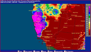
Because of the persistence of the pattern, much of central and northern California has had at least 600% of normal rainfall this month to date. On the other hand, there has been virtually no precipitation east of the Sierras.

Images (click to enlarge): Surface weather map and satellite image for 11 am PDT, June 4, 2011, from HPC/NCEP/NWS; California percentage of normal precipitation for June, 2011 to date, from NWS

Seasonal Outlook

Latest seasonal forecast: Click here.


Latest 3-month temperature outlook from Climate Prediction Center/NWS/NOAA.