Friday, February 25, 2011

San Francisco Snow? (Would Be) Fifth Occurrence in Last Century
Update: No SFO Snow, 1976 Record Holds

Feb. 28 Update: Other than a few flurries, snow failed to materialize in San Francisco. The National Weather Service reports:
As it turns out, a few showers did linger during the early morning hours of February 26th to allow for snow all the way down to sea level. However, only trace snowfall was reported around San Francisco. Therefore the last measurable snowfall in San Francisco still remains 1976. Farther south toward Monterey, light snowfall dustings were also reported. Higher peaks above approximately 2000 feet received more measurable snowfall with a few inches, which is not unusual for this time of year. The overall airmass remained rather unstable during the afternoon of February 26th which resulted in convective rain and snow showers across the region. Several weather spotters reported snow down to sea level once again, but no accumulation was noted.
1:30 PM PST Update: (Headline modified to clarify event is only a possibility.) The latest forecast discussion from the National Weather Service confirms that measurable snow is unlikely below elevations of 500 feet:
 AFTER THE FRONT MOVES THROUGH THE RAIN WILL TURN TO SHOWERS. THE NORTH BAY
MOUNTAINS COULD GET SEVERAL INCHES OF SNOW LATER THIS MORNING INTO
THE AFTERNOON...BUT THE MAJORITY OF THE PRECIPITATION WILL END BY
LATE AFTERNOON NORTH OF THE GOLDEN GATE. THERE COULD BE LIGHT
RAIN/SNOW SHOWERS TONIGHT...WITH SAN FRANCISCO POSSIBLY SEEING SOME
SNOWFLAKES OVERNIGHT...BUT NO ACCUMULATION IS EXPECTED. LOOKS LIKE
THE MAIN AREA THAT HAS THE BEST CHANCE OF SEEING SIGNIFICANT SNOW
WILL BE THE SANTA CRUZ MOUNTAINS AND THE EAST BAY HILLS SOUTH...AND
SOUTH OF THE SANTA CLARA VALLEY IN THE LOWER ELEVATIONS.
Note to Ice Agers: The average change in temperature with height is 5.38°F/1,000 Ft, more when the air is especially cold aloft as in the current situation, so snowfall in the hills doesn't count for any records.

Meanwhile, very heavy rainfall rates have been reported this morning from the storm. A downpour in northeastern San Francisco recorded 0.11" of rain in 5 minutes, a rate of over 1" per hour. Over 2" were reported in 24 hours west of Cupertino.

Original post:
A strong upper-level low pressure area is bringing cold temperatures to the San Francisco Bay area and prompting the National Weather Service to issue a winter weather advisory for elevations above 1000 feet in the North Bay area:
A WINTER WEATHER ADVISORY REMAINS IN EFFECT UNTIL 4 PM PST
FRIDAY.

* SNOW ACCUMULATIONS: 1 INCH 1000 TO 1500 FEET WITH 2 TO 4 INCHES
ABOVE 1500 FEET. 6 INCHES OR MORE FOR ELEVATIONS ABOVE 2500 FEET.

* ELEVATION: HEAVIEST SNOW WILL BE ABOVE 1500 FEET BUT
ACCUMULATING SNOW IS EXPECTED AS LOW AS 1000 FEET.

* TIMING: A MIX OF RAIN AND SNOW WILL CONTINUE THIS EVENING AND
CHANGE TO ALL SNOW OVERNIGHT AS SNOW LEVELS DROP. STEADY PRECIPITATION
WILL CHANGE TO SNOW SHOWERS BY FRIDAY MORNING.
If measurable snow were to occur at sea level, it would be only the 5th such occurrence in the past century, according to Golden Gate Weather Services. Unofficial reports indicate that there were 7 such events in the second half of the 19th century.

H/T: NCAR AtmosNews

Tuesday, February 22, 2011

Minneapolis Sets Single-Storm Snowfall Record

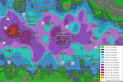
Images (click to enlarge): Feb. 20-21, 2011 total snowfall amounts for metro Minneapolis and for surrounding southern Minnesota and western Wisconsin, from National Weather Service

The 13.8" of snow on February 20-21 in Minneapolis was the largest amount for a single storm in February. It was also the first time more than a foot of snow fell in a single February storm. Some nearby locations reported amounts up to 20".

Of the top 5 February storm totals at Minneapolis, 3 have now occurred in the last 7 years. Climate records at Minneapolis have been collected for 140 years (since 1871).

From the National Weather Service:
Top 5 February Snow Storms for the Twin Cities
1) Feb. 20-21 2011 13.8"
2) Feb. 1-3 2004 11.2"
3) Feb. 19-20 1952 10.5"
4) Feb. 22 1913 8.8"
5) Feb. 24-25 2007 8.7"
The winter snowfall total of 74.9" to date at Minneapolis is now the 10th highest on record for a full season, but it's the 3rd highest to date. The record seasonal total was 98.6" in 1983-84.

The NWS points out that February on average is the least snowiest winter month in Minneapolis. The reason for this is that the upper Midwest is usually dominated by cold high pressure areas in mid-winter. These tend to be relatively dry, and they suppress the prevailing storm track to the south. Except for a stretch of several days in which temperatures failed to rise out of the single digits, this February has been relatively warm at Minneapolis. Through the first 3 weeks, the month has averaged 1.1° above the long-term climatological mean.

Here are some reports of double-digit snow totals from southern Minnesota and western Wisconsin:
20.00   MADISON                  MN  LAC QUI PARLE    0830 PM
19.60 BLOOMINGTON MN HENNEPIN 0825 PM
19.00 3 NW EDEN PRAIRIE MN HENNEPIN 0515 PM
18.00 CREDIT RIVER MN SCOTT 0937 PM
18.00 BURNSVILLE MN DAKOTA 0519 PM
17.50 SPRINGFIELD MN BROWN 0840 AM
16.30 1 SSW MONTEVIDEO MN CHIPPEWA 0700 AM
15.50 2 W PRIOR LAKE MN SCOTT 0900 AM
15.10 LAKEVILLE MN DAKOTA 0814 PM
15.10 RICHFIELD MN HENNEPIN 0820 PM
15.00 OSCEOLA WI POLK 0500 PM
15.00 MENOMONIE WI DUNN 0552 PM
15.00 3 SSW BURNSVILLE MN DAKOTA 0845 AM
14.20 1 N PRIOR LAKE MN SCOTT 0930 PM
14.00 INVER GROVE HEIGHTS MN DAKOTA 1002 PM
14.00 WOODBURY MN WASHINGTON 0800 AM
14.00 EDEN PRAIRIE MN HENNEPIN 0809 PM
14.00 RED WING MN GOODHUE 0730 PM
13.60 ANDOVER MN ANOKA 1024 PM
13.50 MAPLEWOOD MN RAMSEY 1210 PM
13.80 MINNEAPOLIS(MSP AIRPORT) MN HENNEPIN 1240 AM
13.70 CHANHASSEN (NWS OFFICE) MN CARVER 1240 AM
13.30 ST PAUL MN RAMSEY 0610 AM
13.00 GRANITE FALLS MN CHIPPEWA 1013 AM
12.90 3 WNW RICE MN STEARNS 0700 AM
12.70 EDINA MN HENNEPIN 0203 PM
12.70 1 NW BURNSVILLE MN DAKOTA 0700 PM
12.60 COON RAPIDS MN ANOKA 0638 PM
12.50 CARVER MN CARVER 0700 AM
12.40 HASTINGS MN DAKOTA 0907 PM
12.40 ROBERTS WI ST. CROIX 0800 AM
12.30 5 SW ST PAUL MN RAMSEY 0845 AM
12.00 1 N CAMERON WI BARRON 0500 PM
12.00 MANKATO MN BLUE EARTH 0333 PM
12.00 LAKE ELMO MN WASHINGTON 0800 AM
12.00 3 N BLOOMER WI CHIPPEWA 0730 AM
12.00 BALDWIN WI ST. CROIX 0700 AM
12.00 3 SW MINNEAPOLIS MN HENNEPIN 0900 PM
12.00 SHAKOPEE MN SCOTT 0854 PM
11.60 JORDAN MN SCOTT 0710 AM
11.50 MILROY MN REDWOOD 0700 AM
11.10 BLAINE MN ANOKA 0917 PM
11.00 DURAND WI PEPIN 1000 PM
11.00 SAUK RAPIDS MN BENTON 0800 PM
11.00 MORGAN MN REDWOOD 0702 AM
11.00 4 NNE MAPLEWOOD MN RAMSEY 0830 PM
11.00 1 ESE CHASKA MN CARVER 0800 PM
10.60 3 NNW MINNEAPOLIS MN HENNEPIN 0346 PM
10.60 MINNETONKA MN HENNEPIN 0803 AM
10.50 CLAYTON WI POLK 0616 PM
10.50 LITCHFIELD MN MEEKER 0420 PM
10.50 ELK MOUND WI DUNN 0600 AM
10.50 REDWOOD FALLS MN REDWOOD 0500 AM
10.30 7 S HILLMAN MN MORRISON 0335 PM
10.20 OAKDALE MN WASHINGTON 0747 PM
10.00 GLENWOOD MN POPE 0600 PM
10.00 ST JAMES MN WATONWAN 0700 PM
10.00 MADELIA MN WATONWAN 1245 PM
10.00 COMFREY MN BROWN 1210 PM
10.00 BROWNTON MN MCLEOD 1210 PM
10.00 NW GILMAN MN BENTON 0828 AM
10.00 ISANTI MN ISANTI 0626 AM
10.00 EAU CLAIRE WQOW WI EAU CLAIRE 0500 AM
10.00 2 N MENOMONIE WI DUNN 1100 PM
10.00 1 W CARVER MN CARVER 0900 PM
10.00 4 SSW MINNEAPOLIS MN HENNEPIN 0700 PM
10.00 ST PETER MN NICOLLET 0530 PM

Seasonal Outlook

Latest seasonal forecast: Click here.


Latest 3-month temperature outlook from Climate Prediction Center/NWS/NOAA.