Climate Data Links
Local:
Washington, DC climate data
Maryland/DC/Delaware Drought Watch
Virginia Drought Watch
Presidential Inauguration weather
U.S./Global:
Daily to Seasonal Temperatures
Average and Record Weather by City
Drought Monitor
U.S. Streamflow Data
Precipitation Analysis
Current Year Summary
Email CapitalClimate here.
Showing posts with label Record Cold. Show all posts
Friday, December 6, 2013
It Hasn't Cooled Since 1989;
Washington December Daily Low Temperature Records
Images (click to enlarge): December daily record low temperatures for Washington, DC, by year of occurrence; Number of December daily record lows per decade; CapitalClimate charts from National Weather Service data
If you can remember the last time Washington, DC set a daily record low temperature in December, you've been hanging around too long in Babble-On on the Potomac. It was the first year of the G.H.W. Bush administration when a record low of 7° was set on December 23, 1989. The high of 22° that day was also a record low maximum for the date. Since then, there have been no new December record daily lows in the decades of the 1990s, 2000s, or so far in the 2010s. The only other decade with no December cold records was the 1950s.
Here are some other statistics of Washington December low temperature records:
- Half (15) of the daily records were set over 100 years ago, from 1872 through 1904, and 2 more were set 99 years ago.
- The 1880s had the most records of any decade with 7, followed by the 1910s with 5. Interestingly, all of the 1880s records occurred in even-numbered years.
- Except for the 1980s (4 records), no decade since the 1910s has had more than 2 records.
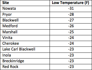
- The all-time coldest December temperature was -13° on December 31, 1880. This was just 2° warmer than the all-time Washington low of -15° on February 11, 1899. It was also a record -7° on December 30, 1880. These are the only December dates with lows below 0°.
Tuesday, May 7, 2013
Weather Whiplash: U.S. Cold Records Crush Heat Records 6.5 to 1 in April


One year after heat records smashed cold records by a ratio of over 35 to 1, preliminary data from the National Climatic Data Center (NCDC) show that new daily low temperature records in the U.S. outnumbered high temperature records by 6.5 to 1 in April. This was the largest monthly excess of cold records so far this decade. It was also the first time since at least February 2010 that more than 2 consecutive months have had more cold records than heat records.
For the spring season to date (March-April), cold records have exceeded heat records by a ratio of 4 to 1, and for 2013 to date, the ratio is 1.6 to 1. On the other hand, for the 12 consecutive months ending in April, heat records continue to outpace cold records by a ratio of 1.8 to 1. Cumulatively, the ratio of heat records to cold records is 2.8 to 1 since January 2010, well above the roughly 2 to 1 in previous decades. As the chart shows, the 2600 cold records in April barely made a dent in the cumulative excess of 36000 heat records since the beginning of the decade.
Preliminary data from NOAA/ESRL show that the coldest temperatures relative to average were in the North Central portion of the U.S. in April. The Pacific Coast states, however, were warmer than average, and near to above average temperatures prevailed over most of the eastern third of the country.
Thursday, March 21, 2013
Think It Was Cold Today, DC? Not Your Great-Great Grandfather's March of the Penguins

Denizens of the DMV were complaining about the early-spring cold this March 21, but the chill was nowhere near the historical extremes for this date or any other date through the end of the month. Although the high for the day of 42° was set shortly after midnight, the daytime temperatures were mostly in the 30s. On the other hand, the afternoon high did reach 41°. This was well below the historical average of 58° in Washington, DC, but it was also a full 10° above the coldest high temperature for the date, which was set in 1885. In fact, it would not be near any coldest high for the remainder of March.
The CapitalClimate chart from National Weather Service data shows that all but 1 of the 13 record coldest high temperatures from March 19-31 were set over 100 years ago. The one exception was 73 years ago, on 03/25/1940.
Sunday, July 22, 2012
32nd Consecutive Warm Week Puts U.S. on Track for Record Hottest Month


Original Post:
With 10 days left in July, the 32nd consecutive week of warmer than average temperatures has put the U.S. on track for the hottest month since national temperature records began in 1895. CapitalClimate analysis of National Weather Service reports from 215 stations across the 48 contiguous states shows that the unadjusted U.S. national average temperature was 3.6° above climatological normal for the week ending yesterday, July 21, up from 2.9° last week. With the National Climatic Data Center adjusted month-to-date average of 77.9° through July 14, it is now likely that the July average through the first 3 weeks of the month will exceed the all-time hottest U.S. month of July 1936 at 77.4°.
This is not a prediction, but if present trends continue, July 2012 would become the new record hottest month. If this does occur, 2 out of the 5 hottest months will have occurred within the last 2 years, and 3 out of the 5 will have occurred within the last 7 years (July 2006 being the third). Note that all of the hottest months shown in the chart at the top are July; the hottest August on record was 75.8° in 1983.
The charts to the right show the current month-to-date average temperatures through July 21 and the July 1936 monthly average. The numerical scales are equivalent, but the color schemes are not identical. In particular, the white area for 1936 corresponds to both yellow and light green for 2012.
Images (click to enlarge):
- Hottest U.S. average monthly temperatures (all July) and 2012 average through July 14; CapitalClimate chart from NOAA/NCDC data
- Weekly average U.S. temperature departures from normal, weeks ending June 4, 2011 (20110604) through July 21, 2012 (20120721); CapitalClimate chart from NOAA/NCDC data
- Average U.S. temperature departure from normal for July 1-21, 2012 from High Plains Regional Climate Center
- Average U.S. temperature departure from normal for July 1936 from NOAA/ESRL
Wednesday, January 4, 2012
Century-Old Florida Low Temperature Records Tied, Broken

Image (click to enlarge): MODIS satellite surface temperature image with surface observations near 2 am EST, January 4, 2012, via CIMSS/University of Wisconsin
Jan. 5 Update: Preliminary data from the National Climatic Data Center indicate the following additional low temperature records were tied in Alabama, Georgia, and South Carolina:
Anniston AL 17 (tie, 2002)Meanwhile, back at the ranch . . .
Macon GA 18 (tie, 2008)
Florence SC 16 (tie, 2008)
Original post:
A strong, but narrow, cold outbreak set or tied daily low temperature records in northern Florida and southern Georgia this morning. At Gainesville, Florida, where records have been kept since 1891, the old record from 1900 was broken by 2°. Preliminary National Weather Service record reports for January 4 at official reporting locations (ASOS stations) include (old record in parentheses):
Alma GA 19 (22, 2001)The 1918 records in southern Florida remained intact, however, as Ft. Lauderdale missed its record of 32° by 10°, and Miami missed its similar record by 11°.
St. Simons Is. GA 26 (tie, 2010)
Naples FL 36 (39, 2002)
Gainesville FL 20 (22, 1900)
Jacksonville FL 22 (tie, 1887)
Apalachicola FL 26 (tie, 2010)
Tallahassee FL 18 (tie, 1928)
Sunday, October 2, 2011
Mid Atlantic Record Low Daily Maximum Temperatures Set or Tied;
Update: Washington Ties Record for 2nd Consecutive Day

Image (click to enlarge): U.S. daily high temperatures for October 2, 2011, from Unisys
October 3, Midnight Update: The National Weather Service reported today that Salisbury, Maryland also set a new record low daily maximum temperature for October 2 (Sunday). The high of 55° beat the old record of 56° in 1940. Salisbury climate records date back to 1900.
October 3, 5:30 PM Update: A late surge of sunshine could change the final result, but today's high temperature so far of 53° at Washington National is tied with the record daily low maximum from 1974. The 51° at Dulles has already missed the record of 49°, also from 1974. Baltimore has also missed the record with 56°, vs. the record of 52°, again from the same year.
October 3, 12 PM Update: The preliminary daily high temperatures are confirmed.
Original post:
Unless temperatures inexplicably jump several degrees in the next hour or so, daily record low maximum temperatures for October 2 will be set or tied at all 3 major reporting locations in the Washington/Baltimore area. The high of 58° at Richmond, however, is 4° above the daily record low maximum. The high of 56° at Philadelphia has also missed its record, which is 53° in 1899. Today's preliminary highs and the previous records for the date in parentheses from National Weather Service climate data:
Washington National 52 @ 1253 PM (52, 1939)
Washington Dulles 50 @ 1226 PM (54, 1974)
Baltimore BWI 51 @ 1120 AM (53, 1939)
Thursday, September 15, 2011
Northern Minnesota's Coldest Temperature So Early in Season

Image (click to enlarge): Median date of first freezing temperature, from Midwestern Regional Climate Center, via National Weather Service
The low temperature of 19° this morning at International Falls, Minnesota was the coldest ever reported so early in the season and an all-time record low for September. The National Weather Service reports:
The low temperature at 7:06 am this morning at International Falls was 19 degrees. This breaks the record low for a September 15th, 24 degrees, set in 1964. This is the coldest temperature reported for so early in the season. This also marks the first time in station history that a temperature in the teens has been recorded in the month of September.The low temperature at Embarrass also reached 19°. The low of 36° at Minneapolis tied the record for the date from 1964 and 2007. The 29° at Eau Claire broke the record of 30° from 2007. Other record lows included:
Rochester MN 31The record lows follow a near-record streak of 80° days at Duluth ending Monday:
Prairie Du Chein WI 27
Viroqua WI 31
Today, September 12th, marks the 5th consecutive day of an 80 degree temperature at Duluth. Only two other stretches have been as long or longer than this in the month of September. Six consecutive days above 80 is the record set in 1906, September 5-10. The other 5 day string was in 1948 from September 1-5.
Thursday, February 10, 2011
Oklahoma All-Time Record Low Temperature

Following yesterday's heavy snow, the Oklahoma Climatological Survey reported this afternoon that a new all-time state low temperature record was unofficially set at Nowata with a reading of -31°:
The Oklahoma Mesonet station at Nowata reached a low temperature of -31 degrees this morning. Pending verification procedures by NOAA's National Climatic Data Center, that mark will eclipse the previous statewide record low temperature of -27 degrees. The previous record was set at Vinita in February 1905 and at Watts in January 1930. Numerous other low-temperature records were broken this morning across the state, with several locations dropping below the previous statewide record. The National Weather Service site in Bartlesville recorded -28 degrees this morning, as did the Oklahoma Mesonet site at Pryor.Other extreme low temperatures are shown below:

Tuesday, February 1, 2011
Record Snows Fueled by Record Heat;
January Heat Outpaces Cold


This is now the 10th month out of the last 13 since last January that heat records have exceeded cold ones. The ratio of high temperature records to low temperature records over that period is 2.18 to 1, and the cumulative excess of heat records is almost 7000.
Images (click to enlarge):
- Monthly total number of daily high temperature, low temperature, and high minimum temperature records set in the U.S. for July 2010 through January 2011, data from NOAA National Climatic Data Center, background image © Kevin Ambrose (www.weatherbook.com). Includes historical daily observations archived in NCDC's Cooperative Summary of the Day data set and preliminary reports from Cooperative Observers and First Order National Weather Service stations. All stations have a Period of Record of at least 30 years.
- Cumulative excess of heat records vs. cold records by month for January 2010 through January 2011, data source as above
Monday, January 24, 2011
Arctic Air Sets Records In New York, New England

Some additional records set or tied include (old record in parentheses):
Worcester MA (KORH) -9.0°F (-3.0°F, 1963)Original post:
Boston MA (KBOS) -2.0°F (0.0°F, 1925)
Glens Falls NY (KGFL) -30.0°F (-25.0°F, 2005)
Syracuse NY (KSYR) -13.0°F (-9.0°F, 2005)
Bradford PA (KBFD) -21.0°F (tied 1963)
Scranton PA (KAVP) -8.0°F (-5.0°F, 1963)
Providence RI (KPVD) -2.0°F (tied 1961)
Montpelier VT (KMPV) -22.0°F (-15.0°F, 1961)
The Arctic air mass which has moved eastward across the northern U.S. set a few daily low temperature records in New York and New England this morning, January 24.
- The low of 4° at Islip, New York beat the old record from 2005 for the date by 1°. However, Islip climate records extend back only 25 years to 1986.
- The low of 6° at Kennedy Airport tied the record set in 2005.
- The low of 0° at Bridgeport, Connecticut broke the old record of 3° set in 1963. Bridgeport climate records extend back to 1948.
- In Central Park, New York, where climate records began in 1869, the low of 6° was 12° above the old record set in 1882.
- The low of -13° at Albany, New York missed the old record from 1948 by 4°.
LOCATION MINIMUM TIME/DATE COMMENTS
TEMP OF
DEG F MEASUREMENT
CONNECTICUT
...LITCHFIELD COUNTY...
FALLS VILLAGE -14.0 700 AM 1/24 COOP
NORFOLK -13.0 700 AM 1/24 COOP
THOMASTON -11.0 700 AM 1/24 COOP
BAKERSVILLE -9.0 700 AM 1/24 COOP
1 WSW REYNOLDS BRIDG -9.0 700 AM 1/24 COOP
MASSACHUSETTS
...BERKSHIRE COUNTY...
NORTH ADAMS -20.0 743 AM 1/24 ASOS
WEST OTIS -17.0 700 AM 1/24 COOP
SAVOY -15.0 700 AM 1/24 COOP
1 WNW BRIGGSVILLE -14.0 525 AM 1/24 WEATHERNET6
PITTSFIELD -14.0 729 AM 1/24 ASOS
ALFORD -12.0 820 AM 1/24 WEATHERNET6
NEW YORK
...ALBANY COUNTY...
COLONIE -21.0 630 AM 1/24 WEATHERNET6
ALCOVE -18.0 700 AM 1/24 COOP
COHOES -14.0 521 AM 1/24 WEATHERNET6
1 NE SHAKERS -13.0 718 AM 1/24 ASOS ALBANY AIRPORT
...COLUMBIA COUNTY...
NORTH CHATHAM -19.0 530 AM 1/24 WEATHERNET6
TAGHKANIC -12.0 541 AM 1/24 WEATHERNET6
LIVINGSTON -10.0 700 AM 1/24 COOP
COPAKE -8.0 700 AM 1/24 COOP
...DUTCHESS COUNTY...
RHINEBECK -20.0 700 AM 1/24 COOP
1 WNW NEW HACKENSACK -14.0 734 AM 1/24 ASOS
RED HOOK -11.0 737 AM 1/24 WEATHERNET6
BEACON HILLS -10.0 700 AM 1/24 COOP
...FULTON COUNTY...
GLOVERSVILLE -22.0 700 AM 1/24 COOP
BROADALBIN -19.0 545 AM 1/24 WEATHERNET6
JOHNSTOWN -15.0 700 AM 1/24 COOP
...GREENE COUNTY...
CAIRO -11.0 700 AM 1/24 COOP
EAST JEWETT -11.0 700 AM 1/24 COOP
GREENVILLE CENTER -11.0 541 AM 1/24 WEATHERNET6
...HAMILTON COUNTY...
INDIAN LAKE -30.0 700 AM 1/24 COOP
LAKE PLEASANT -22.0 700 AM 1/24 COOP
PISECO -22.0 700 AM 1/24 COOP
WELLS -20.0 813 AM 1/24 WEATHERNET6
...HERKIMER COUNTY...
OLD FORGE -31.0 700 AM 1/24 COOP
DOLGEVILLE -20.0 736 AM 1/24 WEATHERNET6
...MONTGOMERY COUNTY...
FORT PLAIN -19.0 700 AM 1/24 COOP
FONDA -16.0 852 AM 1/24 WEATHERNET6
PALATINE BRIDGE -15.0 702 AM 1/24 WEATHERNET6
AMSTERDAM -12.0 544 AM 1/24 WEATHERNET6
GLEN -11.0 612 AM 1/24 WEATHERNET6
...RENSSELAER COUNTY...
BUSKIRK -24.0 700 AM 1/24 COOP
STEPHENTOWN -22.0 700 AM 1/24 COOP
TROY -14.0 700 AM 1/24 COOP
BRUNSWICK -13.0 700 AM 1/24 COOP
...SARATOGA COUNTY...
MALTA -24.0 700 AM 1/24 COOP
1 N THE SARATOGA BAT -22.0 700 AM 1/24 COOP
SARATOGA SPRINGS -21.0 700 AM 1/24 COOP
ROUND LAKE -19.0 700 AM 1/24 COOP
CONKLINGVILLE -18.0 700 AM 1/24 COOP
...SCHENECTADY COUNTY...
DUANESBURG -15.0 641 AM 1/24 COOP
DELANSON -15.0 700 AM 1/24 COOP
NISKAYUNA -9.0 700 AM 1/24 COOP
...SCHOHARIE COUNTY...
COBLESKILL -22.0 700 AM 1/24 COOP
CHARLOTTEVILLE -20.0 700 AM 1/24 COOP
SUMMIT -14.0 944 AM 1/24 WEATHERNET6
SHARON SPRINGS -14.0 700 AM 1/24 COOP
JEFFERSON -10.0 630 AM 1/24 WEATHERNET6
...ULSTER COUNTY...
SAUGERTIES -13.0 653 AM 1/24 WEATHERNET6
SLIDE MOUNTAIN -11.0 700 AM 1/24 COOP
WEST SHOKAN -8.0 636 AM 1/24 WEATHERNET6
HIGHMOUNT -8.0 632 AM 1/24 WEATHERNET6
KINGSTON -4.0 607 AM 1/24 WEATHERNET6
PHOENICIA -3.0 700 AM 1/24 COOP
...WARREN COUNTY...
GLENS FALLS -30.0 733 AM 1/24 ASOS
NORTH CREEK -20.0 700 AM 1/24 COOP
LAKE LUZERNE -18.0 643 AM 1/24 WEATHERNET6
...WASHINGTON COUNTY...
WHITEHALL -25.0 700 AM 1/24 COOP
1 N EAGLE BRIDGE -22.0 144 AM 1/24 WEATHERNET6
2 E BELCHER -21.0 613 AM 1/24 WEATHERNET6
KINGSBURY -18.0 845 AM 1/24 WEATHERNET6
NORTH HEBRON -15.0 700 AM 1/24 COOP
EASTON -14.0 700 AM 1/24 COOP
HUDSON FALLS -13.0 541 AM 1/24 WEATHERNET6
VERMONT
...BENNINGTON COUNTY...
BENNINGTON -22.0 748 AM 1/24 ASOS
SEARSBURG -19.0 700 AM 1/24 COOP
POWNAL -18.0 700 AM 1/24 COOP
SUNDERLAND -18.0 700 AM 1/24 COOP
LANDGROVE TOWN CENTE -16.0 741 AM 1/24 WEATHERNET6
...WINDHAM COUNTY...
WEST WARDSBORO -17.0 700 AM 1/24 COOP
GRAFTON -16.0 700 AM 1/24 COOP
MARLBORO -15.0 700 AM 1/24 COOP
BRATTLEBORO -15.0 700 AM 1/24 COOP
SOMERSET -13.0 700 AM 1/24 COOP
TOWNSHEND -9.0 700 AM 1/24 COOP
Friday, January 21, 2011
Northern Minnesota Coldest in 40+ Years

Images (click to enlarge): January 21, 2011 daily low temperatures in northern Minnesota and Wisconsin, from National Weather Service; US/Canada surface temperatures at 6 am CST, from University of Illinois; Temperature and dewpoint at International Falls for 24 hours ending 2 pm CST, January 21, from National Weather Service
4 PM Update: The National Weather Service has supplied these additional factoids:
The -25 degree low at Duluth is tied for the 5th lowest minimum temperature in the last decade (since 2000). The lowest minimum temperature of the 2000s thus far has been -30 on January 29, 2004.Temperatures by mid-afternoon had warmed to -8° at International Falls.
The state record low temperature in Minnesota was recorded at Tower, Minnesota on February 2, 1996. The low was -60 degrees. That was also the coldest temperature ever recorded east of the Mississippi River.
The state record low temperature in Wisconsin was recorded at Couderay on February 2nd and February 4th of 1996. The temperatures dipped down to -55 degrees both nights.
Original post:
The National Weather Service reports that this morning's low of -46° at International Falls, Minnesota tied the all-time record low at the current airport location set on January 6, 1968. Airport records began in 1939. In the overall International Falls record, which dates back to 1897, this was the 5th coldest reading. The all-time coldest temperature at International Falls is -55°. This occurred on January 6, 1909. Today's -46° temperature was matched at a co-operative reporting station at Babbit MN.
In all, 21 of the 31 January daily record lows at International Falls are -40° or colder. Three daily lows are -50° or colder, all of them set in 1909, on the 6th (all-time record of -55°), 7th (-54°) and 11th (-50°). The average daily low in January is -8.4°.
Other low temperatures for January 21 reported by the National Weather Service include:
TEMP LOCATION ST COUNTY SOURCE
---- ----------------------- -- -------------- -------
-46 INTERNATIONAL FALLS MN KOOCHICHING ASOS
-46 BABBITT MN ST LOUIS COOP
-43 EMBARRASS MN ST LOUIS COOP
-43 BIGFORK MN ITASCA RAWS
-43 ASH LAKE MN ST LOUIS MNDOT
-43 EFFIE MN ITASCA RAWS
-40 LITTLEFORK MN KOOCHICHING COOP
-40 BIRCHDALE MN KOOCHICHING MNDOT
-39 MINONG WI WASHBURN RAWS
-38 CASS LAKE MN CASS RAWS
-38 SQUAW LAKE MN ITASCA MNDOT
-38 CUTFOOT MN ITASCA RAWS
-38 BOVEY MN ITASCA PRIVATE
-38 KABETOGAMA MN ST LOUIS COOP
-38 CRANE LAKE MN ST LOUIS AWOS
-37 MARGIE MN KOOCHICHING MNDOT
-37 HILL CITY MN ITASCA RAWS
-37 ELY MN ST LOUIS RAWS
-37 RICE LAKE MN AITKIN RAWS
-36 LONG LAKE MN ITASCA PRIVATE
-36 JACOBSON MN AITKIN MNDOT
-36 BARNES WI BAYFIELD RAWS
-36 LONGVILLE MN CASS AWOS
-36 PINE RIVER MN CASS AWOS
-36 SEAGULL LAKE MN COOK RAWS
-36 WRIGHT MN ST LOUIS COOP
-35 KABETOGAMA MN ST LOUIS RAWS
-34 MCGRATH MN AITKIN MNDOT
-34 ASH RIVER MN ST LOUIS PRIVATE
-34 GUNFLINT LAKE MN COOK COOP
-34 HAYWARD WI SAWYER RAWS
-34 LIND WI BURNETT RAWS
-34 MOOSE LAKE MN CARLTON RAWS
-33 GRAND RAPIDS MN ITASCA AWOS
-33 COHASSET MN ITASCA PRIVATE
-33 MCGREGOR MN AITKIN AWOS
-33 AITKIN MN AITKIN AWOS
-33 HIBBING MN ST LOUIS RAWS
-33 JENKINS MN CROW WING PRIVATE
-33 EMILY MN CROW WING MNDOT
-33 BRAINERD MN CROW WING ASOS
-33 MOOSE LAKE MN CARLTON AWOS
-33 SOUTH RANGE WI DOUGLAS PRIVATE
-32 GRANTSBURG WI BURNETT PRIVATE
-31 SILVER BAY MN LAKE AWOS
-31 TWO HARBORS MN LAKE AWOS
-31 LEADER MN CASS PRIVATE
-31 DEER RIVER MN ITASCA PRIVATE
-31 SIREN WI BURNETT AWOS
-31 GRANTSBURG WI BURNETT WIDOT
-31 HINCKLEY MN PINE PRIVATE
-30 BREEZY POINT MN CROW WING PRIVATE
-30 TUCKER LAKE MN COOK PRIVATE
-30 GLIDDEN WI ASHLAND RAWS
-30 GORDON WI DOUGLAS RAWS
-29 I-35 MILE 198 MN PINE MNDOT
-29 SEELEY WI SAWYER PRIVATE
-29 4W CLAM LAKE WI BAYFIELD PRIVATE
-29 ISABELLA MN LAKE RAWS
-28 NISSWA MN CROW WING PRIVATE
-28 MERRIFIELD MN CROW WING PRIVATE
-26 DRUMMOND WI BAYFIELD SCHOOL
-26 SUPERIOR WI DOUGLAS AWOS
-26 PHILLIPS WI PRICE AWOS
-25 FERNBERG MN LAKE RAWS
-25 WASHBURN WI BAYFIELD RAWS
-25 PINE CITY MN PINE SCHOOL
-25 DULUTH MN ST LOUIS ASOS
-24 I-35 MILE 181 MN PINE MNDOT
-22 HIGH BRIDGE WI ASHLAND PRIVATE
-22 MAPLE WI DOUGLAS PRIVATE
-21 SILVER CREEK MN LAKE PRIVATE
Thursday, January 6, 2011
U.S. December Cold Records Exceed Heat Records


For the first time in 2010 since February, the December number of daily record low temperatures in the U.S. exceeded the number of record highs. The excess of cold records, however, barely made a dent in the cumulative excess of heat records which had built up to more than 7200 over the spring, summer, and fall. The cumulative excess finished the year 2010 at a little under 7000.
The monthly total of 1052 daily record low minimums also barely exceeded the 903 record high minimums. Both cold and heat records were far exceeded by the over 2500 daily precipitation records.
After reaching a level of over 4:1 in each of April, June, September, and October, the ratio of heat records to cold records was 2.28:1 for the year 2010 overall.
The daily record count shows that the cold extremes were not consistent through the month. They were centered around 3 sharp Arctic outbreaks peaking on the 8th (120 records), 15th (154 records), and 28th (155 records). Heat records dominated strongly during the week ending on Christmas, when a total of only 3 cold records were reported, vs. 207 heat records.
For the entire year 2010, preliminary surface temperature data from NCEP/NOAA show that most of the U.S. averaged near or above the climatological mean, except for the southeast coast and Florida.
Images (click to enlarge):
- Monthly total number of daily high temperature, low temperature, and high minimum temperature records set in the U.S. for July through December 2010, data from NOAA National Climatic Data Center, background image © Kevin Ambrose (www.weatherbook.com). Includes historical daily observations archived in NCDC's Cooperative Summary of the Day data set and preliminary reports from Cooperative Observers and First Order National Weather Service stations. All stations have a Period of Record of at least 30 years.
- Cumulative excess of heat records vs. cold records by month for 2010, data source as above
- High temperature, low temperature, and precipitation records set in the U.S. for December 2010, data source as above
- Daily numbers of high and low temperature records set in the U.S. for December 2010, data source as above
- 2010 annual temperature departure from climatological average from NOAA/NCEP via ESRL
Tuesday, December 14, 2010
Arctic Air Attack Registers Records;
Precipitation, Not Temperature, the Real Story


Is the oft-proclaimed, but never observed, New Ice Age upon us? Well, not quite yet. With the month of December almost half over, the new daily low temperature records have exceeded the new daily highs by a margin of 378 to 191. For the year to date, however, the heat records still exceed the cold records by 7068. At the current rate, the cumulative cold records will catch up to the hot ones in about 491 days, or a little over 16 months.
As usual, focusing on the short term obscures the true picture. Leaving aside the fact that the area of the entire U.S. is less than 2% of the area of the Earth, the latest available December month-to-date average temperature (through the 12th) shows that more of the country is near to above normal than below. Furthermore, the areas with the heaviest snow are not particularly cold.
As was the case with the Mid Atlantic blizzards of last winter, the story here is not temperature, but rather precipitation. The number of daily precipitation records so far in December is 1036, nearly 3 times the number of cold records. On December 1 alone, for example, 334 precipitation records were set, nearly as many as the cold records for the entire month to date. On Sunday, the 12th, the day of the Metrodome collapse, 192 precipitation records were set, vs. only one temperature record. That's right, Jamestown Muni Airport in North Dakota (KJMS) recorded a low of -20°F, surpassing its previous record of -16°F set in 1960. Meanwhile, 13 stations in Minnesota alone were setting daily precipitation records, 5 of them with histories of over 110 years.
Images (click to enlarge): Cumulative excess of daily high temperature vs. low temperature records since Jan. 1, 2010; Total daily temperature and precipitation records Dec. 1-13, 2010; U.S. monthly average temperature departure from normal through Dec. 12. CapitalClimate charts from National Climatic Data Center data, NCEP/NOAA data via ESRL.
Sunday, November 28, 2010
November Cold Records Set in UK

Last night saw November minimum temperature records fall across the country. Most notably both Wales and Northern Ireland recorded the coldest November night since records began. In Wales, temperatures fell to -18.0 °C at Llysdinam, near Llandrindod Wells, Powys. Northern Ireland recorded -9.5 °C at Loch Fea.Heavy snow is forecast for northern and eastern portions of the country this evening and tonight:
Scotland recorded minimum temperature of -15.3 °C at Loch Glascarnoch, whilst England recorded -13.5 °C at Topcliffe in North Yorkshire.
The UK's lowest ever recorded temperature in November was - 23.3 °C recorded in Braemar, in the Scottish Highlands, on November 14, 1919.
Heavy snow will continue to affect southern and central Scotland, northeast England and the east coast of England. Snow showers possibly also fringing into the south coast of England. Elsewhere very cold again but largely dry with widespread frost.The BBC reports that travel conditions have been impacted by "the earliest widespread snowfall since 1993."
The Northern Hemisphere surface and upper-level (500 mb) chart for noon GMT, November 28, shows very strong surface high pressure (1039 mb) centered over Iceland with easterly flow bringing cold air westward over the UK.
Image (click to enlarge): Scene on the A1 highway near Durham in northeastern UK from BBC; Northern Hemisphere surface/500 mb pressure chart from Unisys
Tuesday, July 13, 2010
San Diego's Sub-70 Streak Stops
Six Consecutive Cold Records Set or Tied

July 5 65° (66°, 1933)Temperature records for San Diego extend back to 1875.
July 6 65° (tied 1912)
July 7 66° (tied 1909)
July 8 64° (65°, 1902)
July 9 65° (66°, 1909)
July 10 67° (tied 1916)
Image (click to enlarge): U.S. temperature departure from average, July 1-11, 2010; from Climate Prediction Center/NWS
Friday, February 19, 2010
Richmond Ends Near-Record Cold Streak
For other record temperature posts, see:
Record Heat
Record Cold
Temperatures at Richmond, VA warmed to a high of 49° on Thursday (Feb. 18). This was the first time temperatures had been above 45° since January 28. The 20-day streak of temperatures below 45° was the 3rd longest in records which began in 1897. The longest was a 30-day stretch ending Feb. 9, 1966.
Richmond's high today was 50°. With a low of 31°, the day was 0.5° above normal.
Monday, January 11, 2010
New Florida Cold Records

For other record temperature posts, see:
Record Heat
Record Cold
Jan. 12 Update: Record reports for Tuesday:
A RECORD LOW TEMPERATURE OF 25 DEGREES WAS SET AT MELBOURNE THISAdditional reports for Jan. 11 from Tampa area:
MORNING. THIS BREAKS THE OLD RECORD OF 26 SET IN 1982.
AS OF TODAY...TUESDAY JANUARY 12TH...THERE HAVE BEEN 11 CONSECUTIVE
DAYS WITH MINIMUM TEMPERATURES LESS THAN OR EQUAL TO 32 DEGREES AT
ALMA GEORGIA AND GAINESVILLE FLORIDA AND 10 DAYS AT SAINT SIMONS
ISLAND GEORGIA WITH THE STREAKS STILL IN TACT.
THIS SETS NEW RECORDS AT GAINESVILLE FLORIDA AND ST SIMONS ISLAND
GEORGIA FOR CONSECUTIVE DAYS WITH MINIMUM TEMPERATURES AT OR BELOW
FREEZING AND TIES THE RECORD AT ALMA GEORGIA.
THIS OLD RECORDSA slide show by the National Weather Service office in Jacksonville on the January 9 winter weather event in Florida is available here.
LOCATION MORNING RECORD LOW BEGAN
ARCHBOLD BIO STN :ACHF1 21* 22 IN 1970 1969
AVON PARK 2 W :AVPF1 26* 28 IN 1970 1901
BARTOW :BARF1 27* 28 IN 1978/1970 1892
BROOKSVILLE CHIN HILL :BROF1 24* 26 IN 1942 1892
CHIEFLAND 5 SE :CHIF1 15* 21 IN 1982/1959 1956
FORT MYERS/PAGE FIELD :FMY 31* 32 IN 1959 1902
INVERNESS 3 SE :INVF1 18* 25 IN 1959 1948
LAKELAND LINDER FIELD :LLDF1 23* 31 IN 1977 1948
MOUNTAIN LAKE :LWLF1 24* 25 IN 1970 1935
PLANT CITY :PLCF1 24* 25 IN 1959 1892
PUNTA GORDA 4 ESE :PNTF1 28* 30 IN 1970 1965
SARASOTA-BRADENTON :SRQ 28* 29 IN 1959 1911
ST LEO :STLF1 27 26 IN 1927 1895
ST PETE/ALBERT WHITTED :SPG 33* 34 IN 1977 1914
TAMPA INTERNATIONAL APT :TPA 25* 27 IN 1982 1890
VENICE :VNCF1 32 28 IN 1959 1955
WINTER HAVEN :WHNF1 27* 28 IN 1970 1941
* NEW RECORD LOW FOR JANUARY 11
Original post:
More Florida cold temperature records were set on January 9-11, including the second coldest temperature ever recorded at Key West. Some fruit damage has been reported. The National Weather Service reports, for Monday:
THE TEMPERATURE AT KEY WEST AIRPORT DROPPED TO 42 DEGREES AT 455 AMFor Sunday:
ON MONDAY JANUARY 11TH. THIS SET A NEW RECORD LOW TEMPERATURE FOR
THE DATE. THE PREVIOUS RECORD WAS 48 DEGREES SET IN 1970.
THIS WAS ALSO THE SECOND COLDEST TEMPERATURE EVER RECORDED IN KEY
WEST...WITH WEATHER RECORDS DATING BACK TO 1873. THE ALL TIME RECORD
LOW TEMPERATURE IN KEY WEST IS 41 DEGREES...WHICH HAS OCCURRED
TWICE...ON JANUARY 13TH 1981...AND JANUARY 12TH 1886.
AT 520 AM THIS MORNING, THE TEMPERATURE DROPPED TO 36 DEGREES AT
MIAMI INTERNATIONAL AIRPORT. THIS BREAKS THE PREVIOUS LOW
TEMPERATURE RECORD FOR THIS DATE LAST SET IN 1927.
A RECORD LOW TEMPERATURE OF 33 DEGREES WAS SET AT WEST PALM BEACH TODAY.
THIS BREAKS THE OLD RECORD OF 34 SET IN 1927.
A RECORD LOW TEMPERATURE OF 25 DEGREES WAS SET AT TAMPA THIS
MORNING. THIS BREAKS THE OLD RECORD LOW OF 27 SET IN 1982.
A RECORD LOW TEMPERATURE OF 33 DEGREES WAS SET AT ST PETERSBURG
THIS MORNING. THIS BREAKS THE OLD RECORD LOW OF 34 SET IN 1977.
A RECORD LOW TEMPERATURE OF 23 DEGREES WAS SET AT LAKELAND
THIS MORNING. THIS BREAKS THE OLD RECORD LOW OF 31 SET IN 1977.
A RECORD LOW TEMPERATURE OF 28 DEGREES WAS SET AT SARASOTA
BRADENTON TODAY. THIS BREAKS THE OLD RECORD OF 29 SET IN 1959.
A RECORD LOW TEMPERATURE OF 31 DEGREES WAS SET AT FORT MYERS TODAY.
THIS BREAKS THE OLD RECORD OF 32 SET IN 1959.
A RECORD LOW TEMPERATURE OF 29 DEGREES WAS SET AT ORLANDO
INTERNATIONAL AIRPORT THIS MORNING. THIS TIES THE OLD RECORD OF
29 SET IN 1982.
A RECORD LOW TEMPERATURE OF 17 DEGREES WAS SET AT GAINESVILLE THIS
MORNING. THIS BREAKS THE OLD RECORD OF 20 SET IN 1959.
THIS WAS THE COLDEST MINIMUM TEMPERATURE RECORDED AT GAINESVILLE
FLORIDA SINCE THE TEMPERATURE FELL TO 16 DEGREES ON DECEMBER 24TH
1989.
A RECORD LOW TEMPERATURE OF 14 DEGREES WAS SET AT TALLAHASSEE THIS
MORNING. THIS BREAKS THE PREVIOUS RECORD OF 15 DEGREES SET IN 1982.
THE TEMPERATURE AT KEY WEST AIRPORT REACHED 52 DEGREES AT 246 PM ONFor Saturday:
JANUARY 10TH. THIS SET A NEW LOW MAXIMUM TEMPERATURE RECORD FOR THIS
DATE. THE PREVIOUS RECORD WAS 55 DEGREES SET IN 1970.
A RECORD LOW TEMPERATURE OF 35 DEGREES WAS SET AT MIAMI THIS MORNING.
THIS TIES THE OLD RECORD SET IN 1970.
A RECORD LOWEST MAXIMUM TEMPERATURE OF 48 DEGREES WAS ALSO BROKEN
TODAY AT MIAMI. THE OLD RECORD WAS 53 DEGREES SET 1970.
A RECORD LOW MAXIMUM TEMPERATURE OF 49 DEGREES WAS SET AT FORT
LAUDERDALE ON SUNDAY 01/10/2010. THIS BREAKS THE OLD RECORD OF 50
DEGREES SET IN 1970. THIS ALSO TIES THE LOWEST MAXIMUM TEMPERATURE
FOR THE MONTH OF JANUARY ON RECORD...AND IS 4 DEGREES HIGHER THAN
THE ALL TIME LOWEST MAXIMUM TEMPERATURE ON RECORD WHICH IS 45
DEGREES SET BACK IN DECEMBER OF 1989.
A RECORD LOW MAXIMUM TEMPERATURE OF 50 DEGREES WAS TIED AT WEST
PALM BEACH TODAY. THE OLD RECORD WAS SET IN 1970.
A RECORD LOWEST MAXIMUM TEMPERATURE OF 48 DEGREES WAS SET AT NAPLES
TODAY. THIS TIES THE OLD RECORD OF 51 SET IN 1970.
A DAILY RECORD LOW TEMPERATURE OF 27 DEGREES WAS SET AT DAYTONA
BEACH TODAY. THIS TIES THE OLD RECORD OF 27 SET IN 1970.
A DAILY RECORD COOL HIGH TEMPERATURE OF 44 DEGREES WAS SET AT
ORLANDO INTERNATIONAL TODAY. THIS BREAKS THE OLD RECORD OF 45 SET IN
1970.
A DAILY RECORD LOW TEMPERATURE OF 26 DEGREES WAS SET AT MELBOURNE
TODAY. THIS TIES THE OLD RECORD OF 26 SET IN 1970.
A RECORD LOW TEMPERATURE OF 19 DEGREES WAS SET AT GAINESVILLE TODAY.
THIS BREAKS THE OLD RECORD OF 23 SET IN 2001.
A RECORD LOW TEMPERATURE OF 23 DEGREES WAS SET AT APALACHICOLA THIS
MORNING. THIS BREAKS THE PREVIOUS RECORD OF 25 SET IN 1978.
THE HIGH TEMPERATURE AT TAMPA INTERNATIONAL AIRPORT YESTERDAY
JANUARY 9 WAS ONLY 42 DEGREES WHICH OCCURRED SHORTLY AFTER MIDNIGHT
AT 1221 AM. THIS TIED THE OLD RECORD LOW MAXIMUM FOR THE DATE SET
IN 1970. ON A SIDE NOTE THE DAYTIME (7 AM TO 7 PM) HIGH TEMPERATURE
WAS ONLY 38 DEGREES.
THE HIGH TEMPERATURE AT ST. PETERSBURG - ALBERT WHITTED AIRPORT
YESTERDAY JANUARY 9 WAS ONLY 44 DEGREES WHICH OCCURRED SHORTLY AFTER
MIDNIGHT AT 1220 AM. THIS TIED THE OLD RECORD LOW MAXIMUM FOR THE
DATE SET IN 1970. ON A SIDE NOTE THE DAYTIME (7 AM TO 7 PM) HIGH
TEMPERATURE WAS ALSO ONLY 38 DEGREES.
THE HIGH TEMPERATURE AT SARASOTA-BRADENTON INTERNATIONAL AIRPORT
YESTERDAY JANUARY 9 WAS ONLY 44 DEGREES WHICH OCCURRED AT 100 AM.
THIS BROKE THE OLD RECORD LOW MAXIMUM FOR THE DATE OF 48 DEGREES
SET IN 1970. ON A SIDE NOTE THE DAYTIME (7 AM TO 7 PM) HIGH
TEMPERATURE WAS ONLY 38 DEGREES.
A RECORD COOL HIGH TEMPERATURE OF 40 DEGREES WAS SET AT DAYTONA
BEACH TODAY. THIS TIES THE OLD RECORD OF 40 SET IN 1970.
A RECORD COOL HIGH TEMPERATURE OF 40 DEGREES WAS SET AT ORLANDO
INTERNATIONAL TODAY. THIS BREAKS THE OLD RECORD OF 42 SET IN 1970.
Wednesday, January 6, 2010
Florida Freeze Feeds Futures Frenzy
Orange Juice Prices Increase on Record Cold
For other record temperature posts, see:
Record Heat
Record Cold
The cold Arctic outbreak dominating much of the U.S. has driven up orange juice prices as freezing temperatures in Florida have threatened the crop near harvest time. Prices surged on Monday by 10 cents (7.8%) to reach the daily trading limit. The Wall Street Journal reported late this afternoon, however,
Despite moving sharply higher in early trading after gaining 12% over the previous two sessions, orange juice futures finished marginally lower Wednesday. Market participants took heart in the fact that crop damage overnight appeared to be minimal, as temperatures in the heart of the citrus belt remained just above critical levels. Citrus fruit sustains damage when readings dip below 28 F for three or more hours.Several daily temperature records have been broken or tied across the state. For Wednesday, January 6:
A RECORD LOW TEMPERATURE OF 35 DEGREES WAS SET AT NAPLES TODAY.For Tuesday, January 5:
THIS TIES THE OLD RECORD OF 35 SET IN 1999.
A RECORD LOW TEMPERATURE OF 34 DEGREES WAS SET AT WEST PALM BEACH
TODAY. THIS BREAKS THE OLD RECORD OF 37 SET IN 1967.
A RECORD LOW TEMPERATURE OF 40 DEGREES WAS TIED AT MIAMI TODAY. THIS
TIES THE OLD RECORD OF 40 SET IN 1919.
A RECORD LOW TEMPERATURE OF 28 DEGREES WAS SET AT
LAKELAND THIS MORNING. THIS BREAKS THE OLD RECORD
OF 35 SET BACK IN 1985 AND 1980.
A RECORD LOW TEMPERATURE OF 34 DEGREES WAS SET AT FORT MYERS TODAY.
THIS BREAKS THE OLD RECORD OF 36 SET IN 1956.
A RECORD LOW TEMPERATURE OF 27 DEGREES WAS SET AT TAMPA TODAY.
THIS BREAKS THE OLD RECORD OF 30 SET IN 1999.
A RECORD LOW TEMPERATURE OF 28 DEGREES WAS SET AT VERO BEACH TODAY.
THIS BREAKS THE OLD RECORD OF 32 SET IN 1999.
ALSO...A RECORD COOL MAXIMUM TEMPERATURE OF 55 DEGREES WAS SET AT
[VERO BEACH] TODAY. THIS BREAKS THE OLD RECORD OF 62 SET IN 1969.
A RECORD LOW TEMPERATURE OF 28 DEGREES WAS SET AT DAYTONA BEACH
THIS MORNING. THIS BREAKS THE OLD RECORD OF 30 SET IN 1999.
A RECORD LOW TEMPERATURE OF 31 DEGREES WAS SET AT ORLANDO TODAY.
THIS TIES THE OLD RECORD OF 31 SET IN 1999.
ALSO...A RECORD COOL MAXIMUM TEMPERATURE OF 50 DEGREES WAS SET AT
ORLANDO TODAY. THIS BREAKS THE OLD RECORD OF 57 SET IN 1980.
A RECORD LOW TEMPERATURE OF 27 DEGREES WAS SET AT MELBOURNE THIS
MORNING. THIS BREAKS THE OLD RECORD OF 31 SET IN 1999.
ALSO...A RECORD COOL MAXIMUM TEMPERATURE OF 52 DEGREES WAS SET
AT MELBOURNE TODAY...JANUARY 6 2010. THIS BREAKS THE OLD RECORD OF
57 SET IN 1980.
THE MORNING LOW TODAY WAS 21 DEGREES AT THE JACKSONVILLE INTERNATIONAL
AIRPORT. THIS TIES THE OLD RECORD OF 21 DEGREES SET IN 1884.
A RECORD FOR THE DAILY LOW MAXIMUM TEMPERATURE IN KEY WEST WILL BE LIKELY TODAY
AS THE TEMPERATURE STRUGGLES TO HOVER AROUND 55 DEGREES
THE HIGH TEMPERATURE AT NAPLES ONLY REACHED 55 DEGREES TODAY. THISFor Monday, January 4:
BREAKS THE RECORD FOR THE COOLEST MAXIMUM TEMP OF 56 DEGREES SET
BACK IN 2002.
A RECORD COOL MAXIMUM TEMPERATURE OF 50 DEGREES WAS SET AT MELBOURNE
YESTERDAY...JANUARY [5]. THIS BREAKS THE OLD RECORD OF 51 SET IN
1981.
A RECORD COOL MAXIMUM TEMPERATURE OF 52 DEGREES WAS SET AT VERO
BEACH YESTERDAY JANUARY 5. THIS TIES THE OLD RECORD OF 52 SET IN
1999.
THE HIGH TEMPERATURE YESTERDAY OF 47 DEGREES [AT ORLANDO] WAS A RECORD COOL
MAXIMUM TEMPERATURE FOR JANUARY 5 2010. THE OLD RECORD OF 48 WAS SET
IN 1999.
A RECORD LOW TEMPERATURE OF 26 DEGREES WAS SET AT APALACHICOLA TODAY.
THIS BREAKS THE OLD RECORD OF 27 SET IN 2002.
A RECORD LOW TEMPERATURE OF 26 DEGREES WAS SET AT BRUNSWICK [GA] TODAY.
THIS BREAKS THE OLD RECORD OF 27 SET IN 1979.
A RECORD LOW TEMPERATURE OF 26 DEGREES WAS SET AT APALACHICOLA
YESTERDAY. THIS TIES THE OLD RECORD OF 26 SET IN 2002.
Monday, November 9, 2009
Wettest October in U.S., 3rd Coldest


- Second: Kansas, Nebraska
- Third: Iowa, Wyoming
- Fourth: Colorado, South Dakota, Arkansas
- Fifth: Montana, Minnesota, Missouri
The national average precipitation of 4.15" was almost double the long-term October amount of 2.11". The East North Central and South regions both had their wettest Octobers, and the Central region had its second wettest. Three states had record wettest Octobers: Iowa, Arkansas, and Louisiana. Fourteen other states were ranked in the top five wettest for the month. Only three states had below-normal precipitation.
Images (click to enlarge): U.S. October average temperature since 1895, statewide temperature and precipitation ranks for October 2009; from National Climatic Data Center
Monday, November 2, 2009
Record Monthly Temperatures and Snowfall in October
For other record temperature posts, see:
Record Heat
Record Cold
Midnight Update: October was the second coldest in Denver:
Several monthly cold temperature and snowfall records were set or approached for October in Wyoming, Oklahoma, South Dakota, Nebraska, and Kansas:
Record Heat
Record Cold
Midnight Update: October was the second coldest in Denver:
THE MONTH'S AVERAGE TEMPERATURE WAS ONLY 42.9 DEGREES WHICH MOVED OCTOBER 2009Original post:
INTO THE 2ND COLDEST OCTOBER IN DENVER WEATHER HISTORY.
THE COLDEST OCTOBER WAS A VERY FRIGID 39.0 DEGREES WHICH WAS RECORDED IN 1969.
THERE WERE 17 DAYS WHEN THE LOW TEMPERATURES WERE 32 DEGREES OR LOWER WHEREAS
THE NORMAL AMOUNT IS ONLY 9. THREE HIGH TEMPERATURES
DID NOT MAKE IT TO THE FREEZING MARK WHICH IS 3 ABOVE NORMAL.
Several monthly cold temperature and snowfall records were set or approached for October in Wyoming, Oklahoma, South Dakota, Nebraska, and Kansas:
Wyoming:Meanwhile, monthly high temperature records were set in Florida:
CHEYENNE WY SET NEW RECORDS FOR COLD AND SNOW DURING THE MONTH OF
OCTOBER 2009. A TOTAL OF 28.0 INCHES OF SNOWFALL WAS MEASURED
DURING THE MONTH...WHICH SET A NEW RECORD FOR THE MOST SNOWFALL EVER
RECORDED IN CHEYENNE DURING OCTOBER. THE OLD RECORD WAS 23.1 INCHES
WHICH FELL IN 1906.
CHEYENNE ALSO SET A NEW RECORD FOR THE COLDEST AVERAGE TEMPERATURE
FOR THE MONTH. THE AVERAGE TEMPERATURE FOR OCTOBER 2009 WAS 37.0
DEGREES WHICH JUST EDGED OUT THE PREVIOUS LOWEST OCTOBER AVERAGE OF
37.1 DEGREES SET IN 1969.
Oklahoma:
THE AVERAGE MONTHLY TEMPERATURE AT THE TULSA INTERNATIONAL AIRPORT
FOR OCTOBER 2009 WAS 55.9 DEGREES WHICH WAS 6.7 DEGREES BELOW
NORMAL. THIS TIES WITH OCTOBER 1925 FOR THE COLDEST OCTOBER ON
RECORD. THE DAILY HIGH TEMPERATURES WERE THE PRIMARY FACTOR IN THIS
RECORD SETTING EVENT. THE OBSERVED AVERAGE DAILY MAXIMUM TEMPERATURE
OF 64.5 DEGREES WAS 9.5 DEGREES BELOW NORMAL...WHILE THE DAILY
AVERAGE MINIMUM OF 47.2 DEGREES FELL SHORT BY 3.9 DEGREES. THERE
WERE 8 DAYS IN THE MONTH WHERE THE AVERAGE DAILY TEMPERATURE WAS AT
OR ABOVE NORMAL...WITH THE REMAINING 23 DAYS FALLING BELOW NORMAL BY
-5 TO -18 DEGREES. THE WARMEST TEMPERATURE WAS 84 DEGREES OCCURRED
ON THE FIRST DAY OF THE MONTH...WITH THE COLDEST READING OF 35
DEGREES OBSERVED ON THE 18TH OF OCTOBER. THERE WERE 284 HEATING
DEGREES DAYS DURING THE MONTH WHICH WAS ABOVE NORMAL BY 132 DEGREES
South Dakota:
THE AVERAGE TEMPERATURE FOR THE MONTH OF OCTOBER AT THE RAPID CITY
AIRPORT SOUTH DAKOTA WAS 38.7 DEGREES. THE PREVIOUS RECORD FOR
OCTOBER WAS 39.0 DEGREES BACK IN 2002.
Nebraska:
THE AVERAGE TEMPERATURE FOR THE MONTH OF OCTOBER 2009 IN
SCOTTSBLUFF WAS 40.5 DEGREES. THIS SET A NEW RECORD FOR THE LOWEST
AVERAGE TEMPERATURE IN SCOTTSBLUFF FOR THE MONTH OF OCTOBER. THE
PREVIOUS RECORD WAS 40.8 DEGREES WHICH OCCURRED IN 1925.
THE AVERAGE TEMPERATURE FOR THE MONTH OF OCTOBER 2009 IN CHADRON
NEBRASKA WAS 40.0 DEGREES. THIS SET A NEW RECORD FOR THE LOWEST
AVERAGE TEMPERATURE EVER RECORDED IN CHADRON FOR THE MONTH OF
OCTOBER. THE PREVIOUS RECORD WAS 40.8 DEGREES WHICH OCCURRED IN
2002.
OCTOBER WAS A HISTORIC MONTH FOR SNOWFALL IN NORTH PLATTE. DURING THE
MONTH...30.3 INCHES OF SNOW FELL WHICH WAS A WHOPPING 29.2 INCHES
ABOVE THE NORMAL OF 1.1 INCHES. THE 30.3 INCHES WAS ALSO 1.9 INCHES
ABOVE THE SEASONAL NORMAL OF 28.4 AND WE HAVEN'T EVEN REACHED WINTER
YET! SNOWFALL RECEIVED IN OCTOBER 2009 BROKE THE OLD MONTHLY RECORD
OF 15.7 INCHES WHICH FELL IN 1969. CONSIDERING ALL MONTHS...OCTOBER
2009 WILL GO DOWN AS THE SNOWIEST MONTH EVER FOR NORTH PLATTE. THE
30.3 INCHES RECEIVED...BROKE THE PREVIOUS RECORD OF 27.8 INCHES
RECORDED IN MARCH 1912. IN ADDITION TO THE TWO MONTHLY RECORDS FOR
SNOW...FOUR DAILY SNOWFALL RECORDS WERE BROKEN AND ONE RECORD WAS
TIED. THESE ARE SUMMARIZED BELOW.
DAILY SNOWFALL RECORDS IN OCTOBER 2009 FOR NORTH PLATTE
DATE AMOUNT PREVIOUS RECORD AND YEAR
9 2.0 0.1/1932
10 11.8 1.3/1987 *
13 TRACE TRACE/1969 &
22 4.2 4.0/1906
30 7.3 4.0/1991
Kansas:
THE AVERAGE TEMPERATURE IN GOODLAND KANSAS DURING THIS PAST
OCTOBER WAS 43.7 DEGREES. THIS WAS THE COLDEST AVERAGE TEMPERATURE
ON RECORD FOR THE MONTH OF OCTOBER. THE PREVIOUS RECORD WAS 44.3
DEGREES SET IN OCTOBER 1925.
...SECOND COOLEST OCTOBER AT WICHITA'S MID-CONTINENT AIRPORT
OCTOBER 2009 FINISHED OUT THE MONTH BY GOING DOWN IN THE RECORD
BOOKS AS THE SECOND COOLEST OCTOBER ON RECORD. THE AVERAGE MONTHLY
TEMPERATURE WAS 51.2 DEGREES WHICH IS 7.4 DEGREES BELOW NORMAL.
THIS BEATS OUT THE PREVIOUS SECOND PLACE HOLDER FOR OCTOBER FROM
1917 WHICH HAD AN AVERAGE MONTHLY TEMPERATURE OF 51.9 DEGREES. THE
COOLEST OCTOBER ON RECORD IS 49.0 DEGREES SET IN 1925.
AN ALL-TIME HOTTEST OCTOBER RECORD WAS SET IN MIAMI WITH AN AVERAGEThe National Climatic Data Center reports that 1,344 daily lowest minimum temperature records were set in October, and 616 daily highest maximum records were set.
TEMPERATURE OF 82.4 DEGREES FOR THE MONTH OF OCTOBER. THIS WAS 3.6
DEGREES ABOVE AVERAGE, AND BROKE THE PREVIOUS WARMEST OCTOBER RECORD
OF 82.05 DEGREES SET IN 2002. MIAMI OBSERVED 14 DAYS OF TEMPERATURES
REACHING 90 DEGREES OR HIGHER, WHICH TIED THE RECORD FOR MOST NUMBER
OF 90-PLUS DEGREE DAYS SET BACK IN 1989.
MOORE HAVEN RECORDED A TOTAL OF 18 DAYS OF TEMPERATURES REACHING AT
LEAST 90 DEGREES. THIS BROKE THE PREVIOUS RECORD OF 16 DAYS SET IN
1986. LABELLE REGISTERED 22 DAYS OF 90-PLUS DEGREE TEMPERATURES, ONE
DAY SHORT OF THE RECORD SET IN 2002.
Subscribe to:
Posts (Atom)
Seasonal Outlook
Latest seasonal forecast: Click here.

Latest 3-month temperature outlook from Climate Prediction Center/NWS/NOAA.

Latest 3-month temperature outlook from Climate Prediction Center/NWS/NOAA.