Climate Data Links
Local:
Washington, DC climate data
Maryland/DC/Delaware Drought Watch
Virginia Drought Watch
Presidential Inauguration weather
U.S./Global:
Daily to Seasonal Temperatures
Average and Record Weather by City
Drought Monitor
U.S. Streamflow Data
Precipitation Analysis
Current Year Summary
Email CapitalClimate here.
Wednesday, December 31, 2008
Snow vs. Temperature Records
Recently, we noted the remarkable number of high temperature records set over a large area of the U.S. Meanwhile, Tim Lambert at Deltoid was pointing out the pimping of the snow records being set, particularly in the Pacific Northwest, by the Drudge-amplified deniosphere ("Denialists scraping the bottom of the barrel").
Here's a map from the latest edition of the U.S. Dept. of Agriculture's Weekly Weather and Crop Bulletin that puts the whole thing nicely in perspective. Note that the number of high temperature records (432) not only exceeds the number of snow records (428) by a little, but it also completely annihilates the low temperature records (a measly 37). Furthermore, the week shown ends on Dec. 27, but more high temperature records were set further to the northeast on the following day.
For more analysis on this subject, see "Shoveling Out From a Snow Job".
Image (click to enlarge): Daily Weather Records, Dec. 21-27, 2008, from Weekly Weather and Crop Bulletin, U.S. Dept. of Agriculture
Inauguration Temperature Climatology
The current extended range temperature forecast, shown to the right, indicates a 40% chance of below-average temperatures in Washington for the second week of January. If similar conditions prevail for the Inauguration a week later, what would that imply for temperatures?
The chart of January 20 high temperatures from 1930-2007 shows that, on average, the most likely temperature range is 35-39° (22%), followed by 40-44° (21%). This is the case even though the average is 41.8° because the distribution is skewed toward higher temperatures.
The overall maximum was 70° in 1951 (not an Inauguration year). This is also the all-time high for the date. The next highest value, however, is 60° (1952, 1954, and 2006). Altogether, these are the only 4 instances in the last 78 years in which the high exceeded 59°.
The lowest maximum was 18° in 1994, also an all-time record, but not an Inauguration year. The coldest Inauguration Day was January 21, 1985, which had a record low maximum of 17° and a record low minimum of -4°. (January 20 fell on a Sunday that year.)
Images (click to enlarge): 8-14 day temperature outlook from Climate Prediction Center/National Weather Service/NOAA, CapitalClimate January 20 temperature chart from NWS data (chart image © Kevin Ambrose)
Click here for previous Inauguration weather posts, including a year-by-year chart of high and low temperatures and precipitation.
Monday, December 29, 2008
Countdown to a Change of Atmosphere:
Inauguration Weather Watch 2009
Inauguration Day, January 20, is now 3 weeks from tomorrow. That's beyond the range of accurate daily weather forecasting, but general trends are at least beginning to emerge for the early part of January.
December's temperatures have averaged near the long-term "normal" in Washington, DC; they're now just 0.2° warmer than the 30-year mean. However, they've gotten there the hard way. Within the past week, temperatures have been as much as 16° below average (high of 28° on the 22nd) and also as much as 23° above average (high of 70° yesterday).
The latest extended-range forecast from the National Weather Service's Climate Prediction Center calls for nearly equal chances of above or below average temperatures in the Mid Atlantic region for the 6-10 day period Jan. 4-8. For Jan. 6-12, however, below-average temperatures are more likely.
Stay tuned; the first extended range forecast to include Inauguration Day will be issued a week from tomorrow.
Click here for previous Inauguration weather posts.
Images (click to enlarge): Average temperature forecasts for Jan 4-8 and Jan 6-12, 2009, from Climate Prediction Center/National Weather Service/NOAA
Record High Temperatures in Midwest and Eastern U.S.
PM Update (12 pm): Added December 28 high temperature map and records for locations in the states of Indiana, Illinois, Kentucky, Missouri, Arkansas, Oklahoma, including some records from December 26.
The Weather Channel reports on the air that at least 75 high temperature records were set Saturday and Sunday, December 27-28. In Washington, persistent clouds kept the high of 70° from reaching the 1946 record of 75°, but the record high minimum temperature of 50° for the 28th (dating back to 1881) was tied.
Images (click to enlarge): High temperatures for Saturday, December 27, and Sunday, December 28, from Unisys
Here are some of the records tied or broken (previous record and year in parentheses):
Norfolk, VA . . . . . . 76 (76, 1984)
Bluefield, WV . . . . . 69 (62, 1959)
Blacksburg, VA. . . . . 67 (65, 1971)
Wilmington, NC. . . . . 76 (76, 1971)
N. Myrtle Beach, SC . . 69 (68, 1954)
Raleigh, NC . . . . . . 74 (74, 1988)
Georgetown, DE. . . . . 72 (67, 1954)
Trenton, NJ . . . . . . 66 (65, 1982)
Atlantic City, NJ . . . 69 (68, 1946)
Reading, PA . . . . . . 66 (64, 1982)
Philadelphia, PA. . . . 66 (65, 1982)
Mt. Pocono, PA. . . . . 54 (54, 1982)
Allentown, PA . . . . . 63 (63, 1982)
Erie, PA. . . . . . . . 68 (62, 1936)
Dayton, OH. . . . . . . 66 (64, 1959)
Cincinnati, OH. . . . . 70 (65, 1988)
Columbus, OH. . . . . . 68 (66, 1959)
Akron, OH . . . . . . . 64 (61, 1971)
Cleveland, OH . . . . . 65 (64, 1936)
Toledo, OH. . . . . . . 65 (60, 1971)
Youngstown, OH. . . . . 65 (60, 1982)
Grand Rapids, MI. . . . 60 (58, 1946)
Gaylord, MI . . . . . . 49 (46, 1994)
Traverse City, MI . . . 53 (51, 1994)
Marquette, MI . . . . . 42 (42, 1994)
Saginaw, MI . . . . . . 55 (53, 1936)
Flint, MI . . . . . . . 59 (53, 1946)
Detroit, MI . . . . . . 62 (58, 1971)
Indianapolis, IN. . . . 68 (67, 1959)
Indianapolis, IN. . . . 56 (54, 1907) [high minimum]
Lincoln, IL . . . . . . 69 (64, 1907)
Paducah, KY . . . . . . 74 (68, 1971)
Lexington, KY . . . . . 70 (69, 1942)
Jackson, KY . . . . . . 71 (66, 1982)
Jackson, KY . . . . . . 57 (49, 1982) [high minimum]
Joplin, MO. . . . . . . 70 (70, 2005)
Joplin, MO. . . . . . . 71 (70, 1979) [Dec. 26]
Vichy-Rolla, MO . . . . 69 (68, 1971)
Springfield, MO . . . . 68 (68, 1971) [Dec. 26]
Kansas City, MO . . . . 66 (63, 1954) [Dec. 26]
Camden, AR. . . . . . . 77 (75, 1916) [Dec. 26]
Fayetteville, AR. . . . 69 (66, 1971) [Dec. 26]
Muskogee, OK. . . . . . 76 (69, 1971) [Dec. 26]
McAlester, OK . . . . . 76 (72, 1993) [Dec. 26]
Sunday, December 28, 2008
Science Adviser-Designate Holdren Attacks Global Warming
Here's an interview from last July in which Presidential Science Adviser nominee John Holdren explains why the term "global warming" is too simplified to accurately describe climate change:
Tuesday, December 23, 2008
White Christmas? Record Snowfalls in Northwest, Northeast
Image: Current snow depth as of 7 am EST today from Intellicast/WSI (click to enlarge)
The recent snowstorms have set daily snowfall records at several locations in the Pacific Northwest and New England.
Dec. 22:
Caribou, ME . . . . . . 12.4" (11.6", 1969)
Spokane, WA. . . . . . . 3.8" (2.1", 1952)
Lewiston, ID . . . . . . 2.4" (1.6", 1938)
Boise, ID. . . . . . . . 4.7" (2.4", 1988)
Missoula, MT . . . . . . 3.4" (2.5", 1993)
Dec. 21:
Portland, ME. . . . . . 14.5" (12.4", 1933)
Bangor, ME . . . . . . . 9.7" (7.0", 1995)
Hartford, CT . . . . . . 5.0" (2.6", 1975)
Worcester, MA. . . . . . 8.0" (6.0", 1954)
Burlington, VT . . . . . 9.1" (7.8", 1910)
Albany, NY . . . . . . . 6.6" (5.7", 1887) [Records began 1884]
LaGuardia Airport, NY. . 2.0" (1.7", 1962)
Buffalo, NY. . . . . . . 7.4" (4.0", 1914)
Pendleton, OR. . . . . . 7.4" (3.0", 1938)
Seattle-Tacoma Airpt, WA 3.0" (2.6", 1967)
The Dec. 20-22 storm was one of the top 5 snowstorms since 1940 at Portland, OR Airport:
1. 1950 JANUARY 22.0 INCHES
2. 1968-69 DEC-JAN 14.8 INCHES
3. 1951 MARCH 12.9 INCHES
4. 2008 DECEMBER 12.4 INCHES ******
5. 1980 JANUARY 11.4 INCHES
6. 1995 FEBRUARY 11.0 INCHES
7. 1964 DECEMBER 10.7 INCHES
In downtown Portland, where records date to 1880, this year's storm is not in the top 10:
1. 1893 JAN-FEB 31.8 INCHES
2. 1916 JAN-FEB 27.9 INCHES
3. 1884 DEC 22.3 INCHES
4. 1943 JAN 19.2 INCHES
5. 1919 DEC 17.5 INCHES
6. 1937 JAN-FEB 16.8 INCHES
7. 1980 JAN 16.3 INCHES
8. 1950 JAN 16.1 INCHES
9. 1890 JAN 13.2 INCHES
10. 1956 JAN 13.0 INCHES
DECEMBER 20-22 2008 SNOWSTORM.................10.0 INCHES
For some analysis of why extreme snowfalls, even for an entire season, may not have much significance for climate, see this earlier post regarding last season's records:
Shoveling Out From a Snow Job
Thursday, December 18, 2008
New NOAA Noggin Nearly Named?
Marine Biologist Lubchenco Rumored For Administrator Post
Update 1 am Friday: An article in Friday's WaPo, headlined Advocates for Action on Global Warming Chosen as Obama's Top Science Advisers, reports
More on Lubchenco at NYTi's DotEarth:
Sea Champion Picked for Ocean, Air Agency
Original post:
After former NOAA Administrator Lautenbacher has taken the revolving door to a position on the AccuWeather board of directors, ClimateScience Watch has a pointer to an entry on the WaPo's transition blog. The post by Juliet Eilperin reports that "several sources confirmed today that [Jane] Lubchenco had been picked and was headed to Chicago for the upcoming announcement" of her appointment by President-Elect Obama as NOAA Administrator. Oregon State University professor of marine biology Lubchenco is "a conservationist who has devoted much of her career to encouraging scientists to become more engaged in public policy debates [and] is also a vocal proponent of curbing greenhouse gases linked to global warming."
In a sign of how pathetic an oxymoron "government science" has become under the current administration of Know-Nothings, Eilperin's post quotes University of New Hampshire professor of natural resources and the environment Andrew Rosenberg as asking, "When has NOAA been headed by a member of the National Academy and a fellow of the Royal Society?" In fact, Dr. Robert M. White, the first NOAA Administrator, is a PhD meteorologist who had previously headed the old Weather Bureau during probably its most rapid period of technological advancement. He was later president of the National Academy of Engineering from 1983 to 1995 and a member of the French Legion of Honor and the Academies of Engineering in Japan, the UK and Australia.
President-elect Barack Obama has selected two of the nation's most prominent scientific advocates for a vigorous response to climate change to serve in his administration's top ranks, according to sources, sending the strongest signal yet that he will reverse Bush administration policies on energy and global warming.Jane Lubchenco is expected to be announced as the nominee for NOAA Administrator on Saturday, along with Harvard's John Holdren as presidential science adviser.
More on Lubchenco at NYTi's DotEarth:
Sea Champion Picked for Ocean, Air Agency
Original post:
After former NOAA Administrator Lautenbacher has taken the revolving door to a position on the AccuWeather board of directors, ClimateScience Watch has a pointer to an entry on the WaPo's transition blog. The post by Juliet Eilperin reports that "several sources confirmed today that [Jane] Lubchenco had been picked and was headed to Chicago for the upcoming announcement" of her appointment by President-Elect Obama as NOAA Administrator. Oregon State University professor of marine biology Lubchenco is "a conservationist who has devoted much of her career to encouraging scientists to become more engaged in public policy debates [and] is also a vocal proponent of curbing greenhouse gases linked to global warming."
In a sign of how pathetic an oxymoron "government science" has become under the current administration of Know-Nothings, Eilperin's post quotes University of New Hampshire professor of natural resources and the environment Andrew Rosenberg as asking, "When has NOAA been headed by a member of the National Academy and a fellow of the Royal Society?" In fact, Dr. Robert M. White, the first NOAA Administrator, is a PhD meteorologist who had previously headed the old Weather Bureau during probably its most rapid period of technological advancement. He was later president of the National Academy of Engineering from 1983 to 1995 and a member of the French Legion of Honor and the Academies of Engineering in Japan, the UK and Australia.
Inauguration Weather Update: Chances Improve for Mild January
The official January 2009 weather outlook, released today by NOAA's Climate Prediction Center, indicates at least an equal chance of above average temperatures for the entire contiguous 48 states of the U.S. For the Mid Atlantic region, including the Washington, DC, area, chances are 33-40% for above-average temperatures for the month. While it's still too early for a specific January 20 forecast, the likelihood of a mild Inauguration Day has improved.
Except for the immediate Ohio Valley region, where above-average precipitation is forecast, and the extreme Southeast with below-average rainfall expectations, there is an equal chance of above, normal, or below average precipitation for the month in most of the country. The area of equal chances includes the Washington, DC, area.
Images: January 2009 temperature and precipitation forecasts from NOAA, Climate Prediction Center. Click an image to enlarge.
For earlier inauguration weather posts, see the following:
Wednesday, December 17, 2008
Inauguration Weather Update: Coat Check Contrarian Indicator
With a little over a month to go, it's still too early to make a specific weather forecast for the Presidential Inauguration on January 20. In the meantime, however, here's a contrary indicator for cold weather from Monday's WaPo business section:
When a Coat Rack Is a Peacekeeper
Remembering the coat check chaos that erupted at President Reagan's coldest-ever inaugural in 1985, hotels and other venues have stocked up on hundreds of additional coat racks and thousands of coat hangers.
For what it's worth, despite a cold start, December here in the Nation's Capital is now averaging just 1.2° below the long-term "normal" with only a trace of snow so far. Stay tuned for more information as the weather crystal ball becomes less murky.
For inauguration weather background, see these previous posts:
Friday, December 12, 2008
Record Rainfall in DC, Virginia, West Virginia
Other Records Also Set From North Carolina to New England
PM Update (3:30): Record from North Carolina (Dec. 10):
Asheville, NC. . . . . . 1.97" (1.28", 1967)
Records from Rhode Island, Connecticut:
Providence, RI . . . . . 2.11" (1.78", 1959)
Hartford Bradley, CT . . 1.72" (1.54", 1967)
AM Update (11:00): More Mid Atlantic and Northeast rainfall records.
Final totals are:
Norfolk, VA. . . . . . . 2.77"
Richmond, VA . . . . . . 2.62"
Wallops Island, VA . . . 4.35"
These are all record-breaking amounts, as noted earlier.
The following daily records were also set:
Blacksburg, VA . . . . . 1.75" (1.50", 1969)
Lynchburg, VA. . . . . . 2.14" (0.98", 2001)
Danville, VA . . . . . . 2.04" (1.77", 1967)
Bluefield, WV. . . . . . 1.53" (0.69", 1960)
Harrisburg, PA . . . . . 2.29" (1.63", 2002)
Atlantic City, NJ. . . . 3.68" (1.58", 2003)
Wilmington, DE . . . . . 2.14" (1.50", 1992)
Philadelphia, PA . . . . 2.72" (2.25", 1992)
Avoca, PA. . . . . . . . 1.49" (1.41", 2003)
Trenton, NJ. . . . . . . 2.05" (1.90", 1992)
Bridgeport, CT . . . . . 1.64" (1.49", 1992)
Original post:
The strong storm which brought record snowfall to the Gulf Coast has set new daily rainfall records for portions of the Mid Atlantic area. The new records for December 11 (old record and year in parentheses) are:
Martinsburg, WV . . . . 1.92" (1.24", 2002)
Washington Dulles . . . 1.34" (1.09", 2002)
Washington National . . 1.66" (1.36", 2002)
Norfolk, VA . . . . . . 1.77" (1.64", 1888)
Wallops Island, VA . . .2.04" (1.70", 2003)
Richmond, VA . . . . . .2.64" (1.85", 1960)
The totals for Norfolk and Wallops Island are only through 4 pm. The Richmond total is unofficial; if it's correct, it appears to break the all-time daily December record going back to 1887. The projected final total of 2.76" at Norfolk would also smash the all-time daily December record since 1871.
Thursday, December 11, 2008
November Warmer Than Average in U. S.
NOAA's National Climatic Data Center today released its analysis showing that November 2008 was warmer than the long-term average across the United States. The monthly average of 44.5°F was 2.0°F above the 20th Century average. For the year so far, the January to November average temperature of 54.9°F was 0.3°F above the 20th Century average. Temperature highlights for November from NOAA:
- November temperatures were cooler than average across the Southeast and Central regions, and much warmer than average in the Southwest, Northwest and West regions.
- The West region had its fourth warmest November on record. This contrasted with the Southeast, which was much below normal.
- Persistent above-average temperatures for the last six months have resulted in a record warm June-November period for the West region. California set a record for its warmest June-November, while both Nevada and Utah had their fifth warmest June-November period.
- Based on NOAA's Residential Energy Demand Temperature Index, the contiguous U.S. temperature-related energy demand was 0.6 percent below average in November.
Precipitation averaged 1.93" for the month across the U.S. This was about 10% below the 100-year average. Precipitation highlights:
- The United States measured above-normal precipitation across the northern Great Plains from eastern Montana to western Minnesota. However, November was drier than normal across much of the South and Central regions.
- Precipitation across most of the Midwest was only 50-75 percent of normal and some areas from southern Missouri through central Illinois received less than 50 percent of normal precipitation.
- The January-November period has been persistently wet across much of the country from the central Plains to the Northeast. The 11-month period was the wettest on record for New Hampshire and Massachusetts, second wettest for Missouri, third wettest for Vermont and Illinois, and fifth wettest for Maine and Iowa.
- At the end of November, 22 percent of the contiguous United States was in moderate-to-exceptional drought, about the same as October. Meanwhile, extreme-to-exceptional drought conditions continued in the western Carolinas, northeast Georgia, eastern Tennessee, southern Texas, and Hawaii.
- About 26 percent of the contiguous United States was in moderately-to-extremely wet conditions at the end of November, according to the Palmer Index. This was a decrease of about three percent compared to October.
Gulf Coast Snow: Records Set in Texas, Louisiana
For related posts, including the latest record report, see:Dec. 14 update: Added snowfall map from National Weather Service, New Orleans.
PM Update: Here are more snow totals reported from southeast Texas, the New Orleans region, and parts of Mississippi:
TEXAS:
...BRAZOS...BURLESON...MADISON...HOUSTON COUNTIES...
COLLEGE STATION - 1.5-2 INCH
EASTERWOOD FIELD KCLL - 2.0 INCH
BRENHAM - 3 INCH
MADISONVILLE - 2-3 INCH
HOUSTON COUNTY - 1.0 INCH
CONROE - 1.2 INCH
NAVASOTA - 2.0 - 3.0 INCH
...HARRIS COUNTY...
KINGWOOD - 1.0 INCH
HOUSTON INTERCONTINENTAL - TRACE
CYPRESS - 0.5 INCH
DW HOOKS FIELD - TRACE
SPRING - 1.0 INCH
RICE/WEST U - 0.5 INCH
HOUSTON HOBBY AIRPORT - 0.3 INCH
PASADENA - 2.5 INCH
CHANNELVIEW - 2.5 INCH
LA PORTE - 3.0 INCH
BAYTOWN - 4.0 INCH
HOUSTON (SE) - 0.5 INCH
ELLINGTON FIELD KEFD - 1.0 INCH
...GALVESTON...BRAZORIA COUNTIES...
GALVESTON - 1.0 INCH
CLEAR LAKE - 1.0 INCH
NWS OFFICE - 1.5 INCH
LEAGUE CITY - 1.5 INCH
PEARLAND - 0.5 INCH
SEABROOK - 1.0 INCH
SANTA FE - 2.0 INCH
SWEENY - 0.5 INCH
ANGLETON - 0.5 INCH
...CHAMBERS...LIBERTY...POLK...SAN JACINTO...TRINITY COUNTIES...
TRINITY - 1 INCH
LIVINGSTON - 2.0 INCH
SAN JACINTO COUNTY - 2.5 - 3.0 INCH
MOUNT BELVIEW - 5.0 INCH
LIBERTY - 5.0 INCH
ANAHUAC - 4.0 INCH
WINNIE - 5.0 - 6.0 INCH
MISSISSIPPI:
BOGUE CHITTO...LINCOLN COUNTY... 8 INCHES
HILLSBORO...SCOTT COUNTY... 5 INCHES
COLUMBIA...MARION COUNTY... 5 INCHES
JAYESS...LAWRENCE COUNTY... 5 INCHES
BROOKHAVEN...LINCOLN COUNTY... 5 INCHES
ROOSEVELT STATE PARK... SCOTT COUNTY... 5 INCHES
FLORENCE...RANKIN COUNTY... 5 INCHES
COLLINS...COVINGTON COUNTY... 4.5 INCHES
BRAXTON...SIMPSON COUNTY... 4 INCHES
MIZE...SMITH COUNTY... 4 INCHES
WEST HATTIESBURG...LAMAR COUNTY... 4 INCHES
PRENTISS...JEFFERSON DAVIS COUNTY... 4 INCHES
OMA...LAWRENCE COUNTY... 4 INCHES
JOHNS...RANKIN COUNTY... 3.5 INCHES
3S OF MADDEN...LEAKE COUNTY... 3 INCHES
PUCKETT...RANKIN COUNTY... 3 INCHES
5E OF MCCALL CREEK...LINCOLN COUNTY... 3 INCHES
HAZLEHURST...SIMPSON COUNTY... 3 INCHES
BRANDON...RANKIN COUNTY... 2.5 INCHES
BAY SPRINGS...SMITH COUNTY... 2.5 INCHES
MCCALL CREEK...FRANKLIN COUNTY... 2 INCHES
PURVIS...LAMAR COUNTY... 2 INCHES
SEBASTAPOL...SCOTT COUNTY... 1 INCHES
ROSE HILL...JASPER COUNTY... 1 INCH
ELLISVILLE...JONES COUNTY... 1 INCH
ROXIE...FRANKLIN COUNTY... 1 INCH
FLOWOOD/NWS JACKSON...RANKIN COUNTY... 0.9 INCHES
HATTIESBURG...FORREST COUNTY... 0.8 INCHES
LOUISIANA:
CITY COUNTY/PARISH AMOUNT
AMITE TANGIPAHOA LA 8 INCHES
CROSSROADS PEARL RIVER MS 6 INCHES
MOUNT HERMAN WASHINGTON LA 6 INCHES
ZACHARY EAST BATON ROUGE LA 5.5 INCHES
LIVINGSTON LIVINGSTON LA 5.5 INCHES
BOGALUSA WASHINGTON LA 5 INCHES
SUN ST. TAMMANY LA 5 INCHES
FRANKLINTON WASHINGTON LA 5 INCHES
GREENSBURG ST. HELENA LA 4 INCHES
ENON WASHINGTON LA 4 INCHES
NEW ROADS POINTE COUPEE LA 3 INCHES
BATON ROUGE EAST BATON ROUGE LA 3 INCHES
PORT ALLEN WEST BATON ROUGE LA 2 INCHES
MCCOMB PIKE MS 2 INCHES
NAPOLEONVILLE ASSUMPTION LA 1.5 INCHES
HAHNVILLE ST. CHARLES LA 1.5 INCHES
NEW ORLEANS ORLEANS LA 1 INCH
GRETNA JEFFERSON LA 1 INCH
LAPLACE ST. JOHN THE BAPTIST LA 1 INCH
SLIDELL ST. TAMMANY LA 1 INCH
Portions of the Gulf Coast received an unusual early winter snowfall this morning. The noon radar from The Weather Channel shows the snow retreating into western and central Mississippi, leaving behind 1" of snow on the ground at Baton Rouge. At 7 am this morning, Baton Rouge reported snow with thunder and a temperature of 34°.
All-time record December snow amounts were observed at Beaumont and Port Arthur, Texas, and at Lake Charles, Louisiana. A snow depth of 4" was measured by a TV meteorologist near Beaumont, Texas. As of 10:15 am local time, these snowfall amounts were reported:
TEXAS
-----
LUMBERTON 4.0 INCH
WEST BEAUMONT 4.0 INCH
WOODVILLE 3.0 INCH
BEAUMONT CITY 2.5 INCH
WILDWOOD 2.2 INCH
GROVES 2.0 INCH
SILSBEE 2.0 INCH
SE TX REGIONAL ARPT 1.8 INCH
NEDERLAND 1.0 INCH
ORANGE 1.0 INCH
PORT NECHES 1.0 INCH
JASPER 0.5 INCH
LOUISIANA
---------
EUNICE 3.0 INCH
OAKDALE 3.0 INCH
OPELOUSAS 3.0 INCH
FOREST HILL 2.0 INCH
DE QUINCY 1.5 INCH
VINTON 1.5 INCH
BUNKIE 1.3 INCH
ELMER 1.2 INCH
MOSS BLUFF 1.2 INCH
BELL CITY 1.0 INCH
DERIDDER 1.0 INCH
JENNINGS 1.0 INCH
LAKE ARTHUR 1.0 INCH
SAM HOUSTON JONES SP 1.0 INCH
WOODWORTH 1.0 INCH
SULPHUR 1.0 INCH
LAFAYETTE 1.0 INCH
LAKE CHARLES SALT WB 0.4 INCH
NWS LAKE CHARLES 0.4 INCH
LEESVILLE 0.2 INCH
ALEXANDRIA 911 TRACE
The winter weather forced a postponement of groundbreaking ceremonies for a Naval Meteorology Professional Development Center to be built in Gulfport, Mississippi.
Weather Channel video is here.
Saturday, December 6, 2008
2008: Coolest Year in Decade
An article posted yesterday on the UK Guardian web site reports that 2008 is on track to be the coolest on average since 2000. The preliminary estimate by the UK Met Office is scheduled to be released formally next week. Based on data through October, the global yearly average is expected to be near 14.3°C, which is 0.14°C below the 2001-2007 average. Although the news is likely to be cheered on squawk radio and denialist web sites (It's already being featured here), the article notes:
The relatively chilly temperatures compared with recent years are not evidence that global warming is slowing however, say climate scientists at the Met Office. "Absolutely not," said Dr Peter Stott, the manager of understanding and attributing climate change at the Met Office's Hadley Centre. "If we are going to understand climate change we need to look at long-term trends."The Guardian report is the most viewed article on the guardian.co.uk web site in the last 24 hours, and the second most viewed in the last 7 days.
Image: Long term global temperature trend from Climatic Research Unit, via UK Guardian
Tuesday, December 2, 2008
DC: Definitely Chilly
Coolest November Since 1997
November's average temperature of 46.6° at Washington's National Airport was 2.1° below the 1971-2000 "normal". This made it the coolest November since the 46.2° in 1997, just barely beating out the 46.7° in 2000. The month was tied with 1937 as the 59th coolest November in 138 years of official records. Although the daily high of 74° on both the 1st and 15th was well above the long-term average, no daily high or low records were seriously threatened. The monthly low of 26° on the 22nd was significantly above the record low of 12° for the date.
Does a relatively cold November predict a cold winter? The lower chart to the right shows the relationship between the November average temperature and the following December-January-February average since 1871. The upward sloping trend line indicates that cold Novembers tend to be associated with relatively colder winters, but the relationship is not very strong. The equation of the trend line indicates that for every 1° change in the November average, the winter average moves in the same direction by about 0.4°. On the other hand, there is a lot of scatter in the data. The "R-squared" says that only 19% of the variability of the winter average temperature is accounted for by the November average.
For more details on regression analysis and a discussion of the relationships between temperature and precipitation, see these blasts from the past:
- As December Goes . . .
- Winter Marches On
- Round Rodent vs. Regression
- Who'll Start the Rain?
- Chilly Still on the Menu
Images: CapitalClimate charts from NWS data, photos © Kevin Ambrose
Monday, December 1, 2008
Even More 2008-2009 Winter Weather Outlooks
WSI Corp., a sister company to The Weather Channel and operator of Intellicast, has updated its winter weather outlook for 2008-2009. It calls for a cold December, but a warm January, in the eastern U.S. The Northeast is expected to be colder than normal, and the Southeast warmer than normal, in February:
Click here for previous winter outlook posts.
Images: Predicted storm tracks and snowfall potential for winter 2008-2009 from WEATHERAmerica.
The current cold pattern in the northeastern US should persist through at least the first half of December. A temporary transition to a mild pattern should occur from January into early February, before the pattern reverts back to a much colder regime during the last weeks of winter.Larry Cosgrove's WEATHERAmerica is forecasting a "very wintry Midwest and Eastern Seaboard", including the "possibility of major ice storm formation around Appalachia and the Piedmont (including the markets of Birmingham AL; Atlanta GA; Charlotte NC; Raleigh NC; and Richmond VA)."
Click here for previous winter outlook posts.
Images: Predicted storm tracks and snowfall potential for winter 2008-2009 from WEATHERAmerica.
Sunday, November 30, 2008
Study Indicates Longer Hurricane Seasons
As noted in a previous post, among the records set in the 2008 hurricane season was the one for the "first time major hurricanes have been observed in five separate months". Even before this record became final, a new study analyzed the question of whether hurricane seasons are becoming longer in general. A paper describing the results of this study was recently accepted for publication in the peer-reviewed journal Geophysical Research Letters of the American Geophysical Union.
The study, by Dr. James P. Kossin of the Cooperative Institute for Meteorological Satellite Studies at the University of Wisconsin, first looked at the dates of the first storm and last storm for each season. The results showed that "the time of occurrence of the first and last annual formation events exhibit decreasing and increasing trends, respectively, suggesting that the length of the hurricane season is increasing." The chart to the right above shows a graph of the dates and trend lines. The red lines are the trends for the entire period 1851 to 2007. The blue lines cover only the period of aircraft reconnaissance data, and the green lines are for the satellite observation era.
Looking at just the first and last dates doesn't say anything about shifts in the distribution within the season, however, so Kossin also used a statistical analysis technique called "quantile regression." The quantiles represent subsets within the distribution. For example, 20% of the storm formation dates occur prior to the date at the 0.2 quantile. The quantiles, shown in the charts below (click to enlarge), indicate a negative trend (earlier formation) for the beginning of the season and a positive trend (later formation) for the latter part of the season.
Kossin's overall conclusion is:
A consistent signal emerged that suggests the season has become longer as the earliest formation dates of the season have become earlier and the latest dates have become later. While the sign of these trends remain consistent when different periods are considered, the uncertainty is sometimes high. . . . The analyses presented here show how storm formation dates have been changing within the historical hurricane record, but cannot be used to directly implicate cause for these changes or to accurately predict future changes.
Inauguration Weather Update
The National Climatic Data Center has some inauguration weather factoids in a special report from the 2001 Inaugural. Among the stats are the following:
For more details on inauguration weather, see this earlier post.
Image: Benjamin Harrison inauguration, from Library of Congress via National Climatic Data Center
NASA's Goddard Space Flight Center surveyed the history of inclement inaugural weather, also in 2001.
- Average Noon Temperature when a Republican President is sworn in is 40.4 F.
- Average Noon Temperature when a Democratic President is sworn in is 33.0 F.
For more details on inauguration weather, see this earlier post.
Image: Benjamin Harrison inauguration, from Library of Congress via National Climatic Data Center
Books Close on Record 2008 Hurricane Season
The National Hurricane Center Tropical Outlook on this final day of the official hurricane season notes that:
TROPICAL CYCLONE FORMATION IS NOT EXPECTED DURING THE NEXT 48 HOURS.Jeff Masters has listed in his Weather Underground tropical blog a number of records set this season:
- Fourth costliest hurricane season on record ($21 billion dollars in U.S. damage, according to ISO's Property Claim Services)
- First time major hurricanes have been observed in five separate months (Bertha, Gustav, Ike, Omar, Paloma occurred in July, August, September, October, and November, respectively)
- First time six consecutive storms made U.S. landfall (Dolly, Edouard, Fay, Gustav, Hanna, and Ike).
- First time three major hurricanes have hit Cuba (Gustav, Ike, Paloma)
- Costliest hurricane in Texas history (Ike, $16.2 billion)
- Second deadliest U.S. hurricane since 1972, and 26th deadliest in history (Ike, with 82 dead)
- Highest wind gust ever measured in a hurricane over land (Gustav, 212 mph in Pinar del Rio, Cuba)
- First storm ever to make four landfalls in one state (Fay, in Florida)
- Second strongest November hurricane (Paloma, 145 mph winds)
- Smallest tropical cyclone on record (Marco)
- Longest-lived July hurricane on record, longest-lived hurricane so early in the season, longest-lived tropical storm in July and so early in the season (Bertha, which was a hurricane 7.75 days, eclipsing the previous record of 7 days held by Hurricane Emily of 2005. Bertha was at tropical storm strength for 17.25 days).
- Farthest east forming tropical storm and hurricane for so early in the season (Bertha)
Friday, November 28, 2008
More Winter Weather Outlooks
WUSA, Channel 9, has posted their Washington, DC, 2008-2009 winter weather outlook:
Sue Palka, WTTG, Channel 5, has her outlook here.
Winds of Change: Cleaning Up BushCo's Toxic Waste at EPA and Interior Department
The WaPo has emerged from its election-induced stupor to survey the task ahead of the incoming Obama Administration in repairing the damage done by the current White House Resident to the regulatory environment at the EPA and Interior Department. One example cited in the article:
Webcasts (audio and video) of the Governors' Climate Change Summit, including the address by President-Elect Obama, are available on the conference's web site.
EPA Administrator Stephen L. Johnson overruled his career advisers in deciding to deny California authority to control tailpipe emissions and rejecting their conclusion that global warming poses a threat to public welfare, and Obama is likely to reverse both of those policies shortly after taking office. This month, the president-elect told delegates to the Governors' Global Climate Summit that he would push for a federal cap-and-trade system designed to reduce greenhouse gas emissions to 1990 levels by 2020 and then to cut them an additional 80 percent by 2050, targets Bush has never embraced.In the running for EPA Administrator, according to an accompanying feature, are Mary D. Nichols, current Chair of the California Air Resources Board, and Lisa P. Jackson, former chief of the New Jersey Department of Environmental Protection.
Webcasts (audio and video) of the Governors' Climate Change Summit, including the address by President-Elect Obama, are available on the conference's web site.
Wednesday, November 26, 2008
Winter Energy Outlook
As a cold November in the Mid Atlantic region nears its end, consumers may be wondering about the outlook for heating costs in the upcoming winter. The Natural Gas Supply Association (NGSA) has released its winter 2008-2009 energy outlook (pdf file), calling for a flat trend in natural gas prices:
NGSA analysis of varying data indicates flat overall pressure on natural gas prices this winter, compared with the average for last winter season, primarily due to the following estimates affecting market pressure points:Images: Natural gas winter outlook, seasonal heating degree day forecast ©NGSA
- projected slightly warmer-than-normal winter
- stagnant economic growth
- near record storage inventory, but higher-than-
average storage injection prices- moderate growth in natural gas demand and higher domestic production levels
Tuesday, November 25, 2008
Another Winter Outlook
Another Washington, DC winter weather outlook; this one is from Doug Hill of WJLA, Channel 7:
Video here.
Transcript bottom line:
Video here.
Transcript bottom line:
This winter, we're predicting four times as much snow as last year, about 20 inches for the metropolitan area.
Friday, November 21, 2008
Seasonal Update: Winter 2008-2009 Weather Forecast
The Winter 2009-2010 outlook is here.
Other seasonal forecasts, including the current winter energy forecast, are also available.
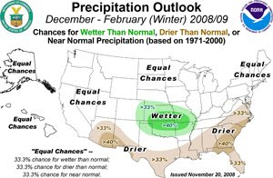
NOAA's Climate Prediction Center announced today the official outlook for meteorological winter (December-January-February). With the expected absence of any strong El Niño/La Niña effects from Pacific Ocean temperatures, conditions are likely to be variable. Temperatures, however, are forecast to be near or above normal everywhere in the continental U.S. Precipitation is forecast to be higher than normal in parts of the central Plains, and drier conditions are likely in the Southeast, Gulf Coast, and portions of the Southwest.
Near equal chances of cooler or warmer than normal temperatures are forecast for the Northeast and Mid Atlantic areas. Near equal chances of wetter or drier than normal precipitation amounts are also predicted, although central and southern Virginia and the Maryland and Virginia Eastern Shore are expected to be drier than normal.
In contrast to many media outlets and web sites which hype their winter snow outlooks to increase their broadcast ratings or page views, NOAA recognizes that there is absolutely no scientific basis for such predictions:
"Snow forecasts are heavily dependent upon winter storms and are generally not predictable more than several days in advance."One broadcaster's view of the winter outlook for the Washington, DC region:
Thursday, November 20, 2008
Capitol Climate Change: LA Waxes Detroit
Ding Dong, Dingell's Gone
In another sign that change is coming to Washington, Rep. Henry Waxman of California today replaced the venerable Rep. John Dingell of Michigan as chairman of the powerful House Energy and Commerce and Committee. Dingell, age 82, has held the chairmanship whenever Democrats have controlled the House since 1981. As a representative from Michigan, Dingell has consistently supported the interests of the auto industry on energy and environmental issues. Waxman, on the other hand, has been an advocate for stronger action on clean energy and climate legislation.
Following the Democratic Caucus vote which elected him Chairman, Rep. Waxman issued the following statement:
I am honored by the vote of the Democratic Caucus. We are at a unique moment and have an opportunity that comes only once in a generation. I will work with all parts of our Caucus and across the aisle to deliver the change that the American public expects us to deliver.From around the Internets:
I have worked with Chairman John Dingell for 34 years. He has been a true legislative champion. I will always admire and respect him and his many legislative accomplishments.
- Politico: Waxman dethrones Dingell as chairman
- NYti: Longtime Head of House Energy Panel Is Ousted
- Baltimore Sun, Waxman to chair House energy, commerce panel
- MSNBC, OUT WITH THE OLD?
- AP, Waxman topples Dingell; House Dems go greener
- Bloomberg, Waxman Defeats Dingell for Control of Energy Panel
- Globe and Mail, It's the little things
- Seattle PI, New environmental cast in D.C. signaled by election today of Waxman, Stevens' defeat
- WSJ Environmental Capital, Waxing Nostalgic: Does Waxman Victory Mean Slam Dunk for Climate Bill?
- Nature.com blog, In a year of change, Democrats take down one of their own
Wednesday, November 12, 2008
Political Climate: Inauguration Weather
Today's WaPo includes a graphic representation of presidential inauguration weather (click to enlarge):
Weather doesn't follow a 4-year cycle, so here are CapitalClimate charts of the detailed January 20 Washington, DC, temperature and precipitation records since 1933:
Note the large temperature range, from a high of 70° in 1951 (not an inauguration year) to a low of -2° for Reagan's second inaugural in 1985, the coldest inauguration in history. The long-term averages of 42° for a maximum and 27° for a minimum are equal to the coldest of the year in Washington.
The record precipitation for the date of 1.77" fell in 1937. An inch or more also occurred in 1979 and 1988, with 1995 close behind at 0.99". In all, 39 out of the last 78 years since 1930, or exactly 50%, have had at least a trace of precipitation on January 20.
The maximum snowfall on the date was 3.8" in 1975, although 7" fell the day before Kennedy's inauguration in 1961. At least a trace of snow fell in 23 years, or just under 30% of the time. Of those, 17 had measurable amounts, and 1" or more was observed 9 times. The maximum amount of snow on the ground was the 8" in 1961. There has been a trace or more of snow on the ground in 25 of the years since 1930, and 19 of those had at least an inch.
So, the bottom line of inauguration weather history is: If you're planning to attend the events, particularly those outdoors, be prepared with a variety of clothing and footwear.
Other references on inauguration weather history:
- National Weather Service, Presidential Inaugural Weather
- Maryland Weather, Inaugural weather can be d'icey
Monday, November 10, 2008
A Breath of Fresh Air
ClimateScienceWatch notes that President-Elect Obama has stated in writing, "In an Obama Administration, the principle of scientific integrity will be absolute. I will never sanction any attempt to subvert the work of scientists."
Meanwhile, Sunday's WaPo reports, Obama Positioned to Quickly Reverse Bush Actions:
The N.Y. Times has a similar report, Obama Weighs Quick Undoing of Bush Policy.
Meanwhile, Sunday's WaPo reports, Obama Positioned to Quickly Reverse Bush Actions:
Transition advisers to President-elect Barack Obama have compiled a list of about 200 Bush administration actions and executive orders that could be swiftly undone to reverse White House policies on climate change, stem cell research, reproductive rights and other issues . . .One potential target for reversal mentioned in the article is the Bush Administration's refusal to grant California a waiver to allow regulation of greenhouse gases from automobiles.
The N.Y. Times has a similar report, Obama Weighs Quick Undoing of Bush Policy.
Today's Forecast: "Hot, Flat, and Crowded"
Author Thomas Friedman's recent lecture presented by Politics and Prose in Washington, DC, is available as a streaming webcast. Copies of the PowerPoint slides are included.
Sunday, November 9, 2008
Paloma Stalls Over Cuba, Weakening to Tropical Depression
After making landfall on the southern coast of Cuba Saturday evening, Hurricane Paloma weakened rapidly, becoming a tropical storm by 7 am today. Late this afternoon, the storm was downgraded to a tropical depression. As of 4 pm, maximum winds are down to 35 mph, and further weakening is expected through tonight.
Tropical Depression Paloma is barely moving toward the north at 1 mph, and a slow northward drift will keep the storm or its remnants near the north coast of Cuba on Monday. Additional rains of 1 to 2 inches are forecast over central and eastern Cuba and the Bahamas.
Saturday, November 8, 2008
Category 4 Hurricane Paloma Ties, Sets November Records
Extremely Dangerous Storm Approaching Cuba
7 pm Update: Major Hurricane Paloma made landfall near Santa Cruz del Sur, Cuba, around 6:20 pm as a strong Category 3 storm with maximum winds of 125 mph. Winds have now decreased to 120 mph, and further weakening is expected over the next couple of days.
4 pm Update: As of 4 pm, maximum winds have increased to 145 mph, making Paloma the second strongest Atlantic hurricane in November. Little decrease in strength is expected before landfall.
Original post:
Major Hurricane Paloma has intensified to Category 4, with maximum winds of 140 mph. Paloma is now tied for the second strongest November hurricane in the Atlantic basin. The strongest was Hurricane Lenny of 1999, which reached maximum sustained winds of 155 mph. Hurricane Michelle, which followed a very similar track in 2001, also had peak winds of 140 mph in November, although that storm formed in the last few days of October. Also tied for second place is Hurricane Greta of 1956.
Jeff Masters notes in his blog that this is the first time in history that major hurricanes have occurred in 5 separate months of the same season: Bertha (July), Gustav (August), Ike (September), Omar (October), Paloma (November). The only other season with as many as 4 was the notorious 2005 of Katrina and friends.
Some weakening is likely in the short term, but Paloma is expected to make landfall on the southern coast of central Cuba as a major hurricane. Hurricane Warnings continue in effect for the southern and northern coasts of central Cuba. After making landfall tonight and crossing Cuba, the storm is forecast to weaken and stall south of the Bahamas.
At 1 pm, Paloma was centered about 65 miles southwest of Santa Cruz del Sur, Cuba, moving east northeast at 9 mph. This track is expected to continue through Sunday with some decrease in forward speed after landfall.
Images: Radar from Instituto de Meteorologia de Cuba, Infrared satellite view from NOAA, Paloma forecast track from National Hurricane Center, Lenny and Michelle tracks from NOAA Coastal Services Center
Friday, November 7, 2008
Dangerous Hurricane Paloma Now A Major Storm
Aircraft reconnaissance reports indicate that Hurricane Paloma has now become a major Category 3 storm with maximum winds of 115 mph. The storm continues to move north northeast from a position about 30 miles south of the eastern end of Grand Cayman Island. Hurricane Warnings remain in effect for the Cayman Islands and several provinces of central Cuba. Landfall is likely on the central Cuban coast late Saturday.
Hurricane Paloma Continues Strengthening to Category 2
After reaching hurricane strength Thursday evening, Hurricane Paloma has continued intensifying today. The storm is now at Category 2, with maximum sustained winds of 105 mph. Hurricane Warnings are in effect for the Cayman Islands and the Cuban provinces of Sancti Spiritus, Ciego de Avila, Camaguey, and Las Tunas. A Tropical Storm Warning is in effect for Granma province.
Paloma is centered about 40 miles south of Grand Cayman, moving north northeast at 6 mph. The track is forecast to turn more toward the northeast tonight.
Further strengthening is likely, with the storm possibly becoming major (Category 3) before landfall on the southern coast of central Cuba.
Paloma is centered about 40 miles south of Grand Cayman, moving north northeast at 6 mph. The track is forecast to turn more toward the northeast tonight.
Further strengthening is likely, with the storm possibly becoming major (Category 3) before landfall on the southern coast of central Cuba.
Thursday, November 6, 2008
PM Update: Tropical Storm Paloma Strengthens
4 pm Update: The Hurricane Watch has been upgraded to a Hurricane Warning for the Cayman Islands. Maximum winds are now 65 mph.
Original post:
Aircraft reconnaissance has determined that Tropical Storm Paloma, which developed from Tropical Depression 17, has strengthened. Maximum winds are now 60 mph. At 1 pm, Paloma was centered a little over 100 miles northeast of the border between Honduras and Nicaragua. Movement is to the north at 7 mph, and a turn more to the northeast is expected by late tomorrow.
The forecast track brings the storm near the Cayman Islands as a hurricane and then across central or eastern Cuba toward the Bahamas. A Hurricane Watch is in effect for the Cayman Islands.
Models continue to indicate that further intensification is likely, and major hurricane status is possible, in the next couple of days. The probability of rapid intensification is 3 to 4 times the climatological average.
Images: Caribbean satellite image from The Weather Channel, Paloma forecast track from National Hurricane Center, Tropical Cyclone Heat Potential from NOAA/AOML
Wednesday, November 5, 2008
PM Update: Depression 17 Forms in Caribbean;
Likely to Become Hurricane Paloma
In a reminder that the official hurricane season lasts through November, a stormy area in the southwestern Caribbean has organized this afternoon into Tropical Depression 17. Atmospheric and oceanic conditions are favorable for development, and the depression is expected to become a tropical storm and possibly a hurricane in the next couple of days. Two major models are forecasting the storm to reach major hurricane strength before crossing Cuba.
Maximum winds are now about 30 mph as the depression moves northwest at 5 mph. Heavy rains are predicted for eastern Honduras and northeastern Nicaragua as the storm moves near the coast, then turns more northerly and eventually northeasterly toward eastern Cuba.
Images: Caribbean satellite image from The Weather Channel, TD 17 forecast track from National Hurricane Center
Monday, November 3, 2008
Environmental Pollution Agency Update:
Lame Duck Still Bites
The WaPo's lead article on Halloween, A Last Push To Deregulate, reported that BushCo is racing the calendar to undermine as many government regulations as possible, including those applying to the environment. Apparently not content simply to refuse to do their job under court order,
This story was picked up today by Reuters (via AOL News): Bush Team Rushes Environmental Rules. Other comments are provided by:
The White House is working to enact a wide array of federal regulations, many of which would weaken government rules aimed at protecting consumers and the environment, before President Bush leaves office in January.One environmental rule, apparently opposed even within the ineffectual EPA,
would allow current emissions at a power plant to match the highest levels produced by that plant, overturning a rule that more strictly limits such emission increases. According to the EPA's estimate, it would allow millions of tons of additional carbon dioxide into the atmosphere annually, worsening global warming.George Washington University constitutional law scholar Jonathan Turley points out that this last-minute rule-making, while technically legal, does "violate a core tradition in American politics."
This story was picked up today by Reuters (via AOL News): Bush Team Rushes Environmental Rules. Other comments are provided by:
- NYTi's Green Inc. blog, Bush’s Last-Minute Rule Making Has Environmental Implications
- ABC News, The Bush Administration's Midnight Regulations
- TIME, Offsetting Bush's Green Legacy: Advice for No. 44
- Federal Times, Midnight rule-making bonanza
- Comedy Central's Indecision 2008, George Bush Apparently Still President, Still Destroying the World
Thursday, October 30, 2008
Colbert's Conservation Campaign:
Save the Hummer!
"The Hummer is in danger, but one patriotic group is working to save our chariot of freedom":
Friday, October 24, 2008
Climate Capital: Economics of Global Warming
10/25 Update: The online WSJ's Environmental Capital blog points out that the economic slowdown has also lowered the cost of pollution permits, further decreasing the incentive to reduce emissions:
Original post:
Implicit in the name of this blog is the notion that climate change, although fundamentally a scientific problem, is inextricably bound up with the economics of dependence on fossil-fueled energy. PBS' Frontline documentary series followed up their previous coverage of climate change this week (Tuesday night on most stations) with a 2-hour program titled simply "Heat". As stated in the show's synopsis:
If you missed the program, or if you want to review individual sections, video is available on the show's website. Also available on the site are supplemental interviews and audience responses. A teacher's guide and transcript are scheduled to be posted soon.
The price of a carbon permit under Europe’s emissions-trading scheme has dropped 15% in the last two weeks to reach an 8-month low of 20.15 euros.Prices dropped another 5% on Friday alone.
Original post:
Implicit in the name of this blog is the notion that climate change, although fundamentally a scientific problem, is inextricably bound up with the economics of dependence on fossil-fueled energy. PBS' Frontline documentary series followed up their previous coverage of climate change this week (Tuesday night on most stations) with a 2-hour program titled simply "Heat". As stated in the show's synopsis:
On the eve of a historic election, award-winning producer and correspondent Martin Smith investigates how the world's largest corporations and governments are responding to Earth's looming environmental disaster. . . Smith traveled to 12 countries on four continents to investigate whether major corporations and governments are up to the challenge. HEAT features in-depth interviews with top policy-makers and with leading executives from many of the largest carbon emitters from around the world, including Chinese coal companies, Indian SUV makers and American oil giants. The report paints an ominous portrait. Despite increasing talk about "going green," across the planet, environmental concerns are still taking a back seat to shorter-term economic interests.This conclusion regarding short-term concerns, which was apparent even before the latest implosion of cowboy capitalism, is even more true in the current economic climate. Correspondent Smith made note of this in a response to a question in a WaPo online chat the day after the program aired:
For many scientists the signs are already apparent - what we saw in the Himalayas, what's happening in the Arctic, the increased strength of storm. And millions more people every year are coming to grips with this. But it's hard to pay attention to melting ice caps, when their 401Ks are melting at an even more rapid rate.In fact, the problem is worse than lack of public attention or even the diversion of capital away from climate to more immediate concerns. A front-page WaPo article on Monday, As Fuel Prices Fall, Will Push For Alternatives Lose Steam? points out that the lower price of energy in a slowing economy removes much of the economic incentive to develop alternate energy technologies.
If you missed the program, or if you want to review individual sections, video is available on the show's website. Also available on the site are supplemental interviews and audience responses. A teacher's guide and transcript are scheduled to be posted soon.
Subscribe to:
Posts (Atom)
Seasonal Outlook
Latest seasonal forecast: Click here.
Latest 3-month temperature outlook from Climate Prediction Center/NWS/NOAA.