
An entire June week without air conditioning in the DC metro area has been a real treat, especially in light of large jumps in electric rates by Pepco (39%) and BGE (72%). That trend continues into at least part of another week while Alberto, the first storm of the new hurricane season, verges on hurricane strength in the Gulf of Mexico.
Outlook: Tonight and Tomorrow

Tonight's lows under clearing skies will be near 60 in the city to the low 50s in the cooler 'burbs with low humidity. Tomorrow will be sunny with more June-like highs in the low 80s.
For the outlook through next weekend, scroll down to
Jason's post below.

This morning's showers brought a welcome 0.39" to National and a similar 0.35" to Dulles. The cumulative June precipitation map through last night from the National Weather Service shows widespread deficits for the month in the Washington DC region. The red-orange areas covering much of the immediate suburbs had received less than 25% of the normal monthly amount so far. The lighter orange areas had received 25-50% of normal.
The outbreak of sun this afternoon has allowed temperatures to rebound nicely from the chilly high 50s of late morning, although the official reading was still only 68° with an ESE wind at 4pm. The 12-degree jump in one hour at Dulles from 64° at 1pm to 76° at 2pm looks a little suspicious, although it does coincide with a wind shift from ENE to NW.
Talkin' Tropical
The new hurricane season is off to a fast start as what was a weak low pressure area with little prospects stubbornly overcame southwesterly wind shear to be near hurricane strength at 70 mph by late this morning. The latest
projected path has been revised westward to keep the storm more inland after landfall tomorrow on the Florida Gulf Coast. It is shown moving through southern Georgia, South Carolina, and North Carolina before emerging back into the Atlantic as a depression over the northern Outer Banks. As of 5pm, a hurricane warning is in effect on the Gulf Coast from Longboat Key to the Ochlockonee River, and a tropical storm warning is in effect on the Atlantic Coast from Flagler Beach FL northward to the Georgia/South Carolina border.
It's buried with the bureaucratic news on the Federal Page, but today's WaPo has an
article on the National Hurricane Center's experimental new
Hurricane Weather Research and Forecast Model for predicting hurricane intensity.
 Lows tonight in the mid 60s city to mid 50s in the cooler 'burbs with comfortable humidity should allow the AC to stay off for another night. Temperatures and humidities will creep up under sunny skies tomorrow with highs 88° to 90°.
 Despite some second-guessing in the earlier comments (myself included), temperatures under brilliant blue skies are topping out in the mid 80s in the immediate Washington DC metro area. National dropped back 2° after hitting 85° at 3pm. In the southern fringes of the region, Fredericksburg and Stafford both reached 88°, as did reliably warm Frederick on the northern side.
 The remnants of Alberto have scooted northeastward to just off Nova Scotia this afternoon. The storm has strengthened as a non-tropical system, prompting the Canadian Meteorological Service to issue
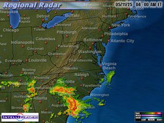
  The National Hurricane Center discontinued advisories on Alberto as it became non-tropical this morning, but heavy rains are continuing from the remnants of the storm, and it will probably strengthen as it moves out over the Atlantic tonight. After receiving almost 1½" of rain through early this afternoon, Norfolk collected over 1" more in the hour ending at 4pm and over 2" in the 3 hours just ended. Rain has tapered off at Raleigh after more than 5" fell in the 6 hours ending at 2pm.


