Saturday, June 23, 2012

Tropical Storm Debby: Earliest 4th Atlantic "Named" Storm by 11 Days


Continuing the record early pace of the 2012 Atlantic tropical season, Tropical Storm Debby, named by the National Hurricane Center (NHC) at 5 pm today, is the earliest 4th named storm or equivalent of the season. According to the NHC historical storm database (dating back to 1851) and counting tropical cyclones prior to the introduction of names in 1950 as well as subtropical cyclones, the previous earliest 4th storm was Dennis, which originated on July 4, 2005. The average date for the 4th Atlantic storm of the tropical season is September 1.

Friday, June 22, 2012

More Mid Atlantic, Northeast High Temperature Records (June 21-22)


The record high temperatures continued into June 21st and partly into the 22nd in the Mid Atlantic and Northeast. Once again, records from 1953 were broken in several locations.

From National Weather Service preliminary reports (old record and date in parentheses):
Salisbury MD       98 (97, 1923) 
Washington DC 99 (98, 1988/1933/1923)
Baltimore MD 100 (tie, 1923)
Wilmington DE 98 (97, 1923)
Georgetown DE 99 (95, 1964)
Georgetown DE 97 (95, 2010) [June 22]
Kennedy Airpt NY 97 (95, 1988)
Kennedy Airpt NY 94 (92, 1997) [June 22]
LaGuardia Airpt NY 98 (97, 1953)
Islip NY 95 (93, 1988)
Islip NY 94 (91, 1988) [June 22]
Bridgeport CT 96 (95, 1953)
Hartford CT 96 (tie, 1953)
Worcester MA 91 (tie, 1953/1949/1938)
Boston MA 96 (95, 1949/1923)
Burlington VT 97 (95, 1953)

Wednesday, June 20, 2012

Record Heat Moves Into Mid Atlantic, Northeast;
6-20-53 Records Fall


Image (click to enlarge): Temperature departures from climatological average (°C), June 20, 1953, from NOAA/ESRL

The great heat wave of June 1953 was focused mainly in the Central and Southern Plains, but on the 20th record heat extended northeastward through the Midwest and across New England into the Canadian Maritimes. Many records were established across the region which were still standing for over a half century until several of them were tied or broken today. Based on preliminary reports from the National Weather Service, here are some of those records (previous record and date in parentheses):
Richmond VA        98 (tie, 1933)
Wheeling WV 93 (92, 1953)
Morgantown WV 93 (tie, 1953)
Wheeling WV 93 (92, 1953)
Salisbury MD 97 (95, 1923)
Georgetown DE 98 (97, 1964)
Wilmington DE 97 (tie, 1895)
Mt. Pocono PA 89 (tie, 1953)
Newark NJ 98 (97, 1953)
Binghamton NY 90 (tie, 1953)
Kennedy Airpt NY 94 (93, 1995)
LaGuardia Airpt NY 98 (96, 1953)
Hartford CT 97 (96, 1995/1953)
Burlington VT 95 (94, 1988)
Portland ME 93 (tie, 1964)
Houlton ME 90 (89, 1988)

Deluge Drowns Duluth: Wettest June Day, Second Wettest All-Time in 142-Year Rainfall Record


Torrential rainfall up to 9" yesterday caused widespread flooding in the Duluth, Minnesota, area and closed roads, including I-35:
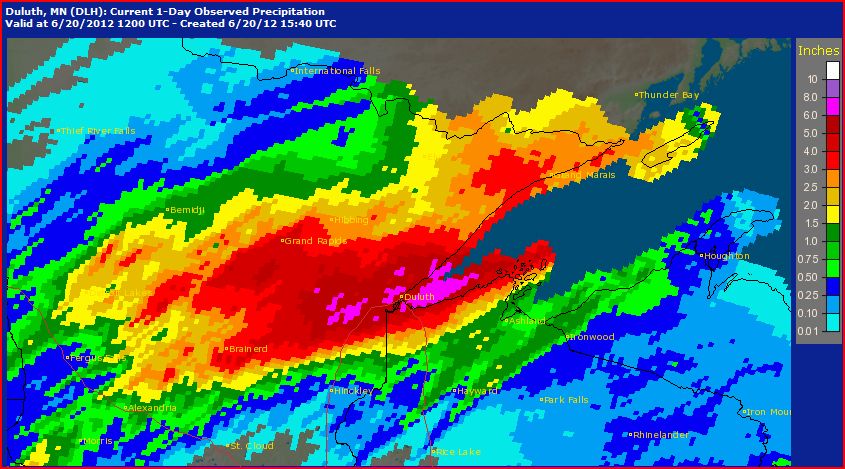
Major flooding in and around Duluth has isolated neighborhoods, drowned zoo animals and closed state parks, pushing the city's mayor to declare a state of emergency after more than 8 inches of rain had fallen across areas of northeastern Minnesota.

Steady, torrential rain closed Interstate 35 and downtown tunnels in Duluth. Police say sinkholes and washouts have made travel dangerous. Residents of the south Duluth neighborhood of Fond du Lac, near the rising St. Louis River, were being asked to leave their homes.
The National Weather Service simply noted drily that the daily rainfall record was smashed by a factor of over 2.5 to 1:
A RECORD RAINFALL OF 4.14 INCHES WAS SET AT DULUTH INTERNATIONAL
AIRPORT YESTERDAY. THIS BREAKS THE OLD RECORD OF 1.55 SET IN 1998.
A CapitalClimate analysis of National Climatic Data Center reports from downtown Duluth (1871 to 1941) and Duluth Airport (1941 to 2011) shows that this was also the all-time June record daily precipitation, exceeding the 4" on June 23, 1876. Furthermore, this was second only to the 5.2" on July 21, 1909 for the wettest day in the 142-year record.

Some other precipitation reports from the Duluth area:
INCHES  LOCATION                 ST  COUNTY           TIME
------ ----------------------- -- -------------- -------
9.00 4 SW DULUTH MN ST. LOUIS 0941 AM
DENFELD NEIGHBORHOOD OF WEST DULUTH
8.38 DULUTH MN ST. LOUIS 0800 AM
THIS MEASUREMENT WAS TAKEN IN THE MORLEY
HEIGHTS NEIGHBORHOOD.
8.34 ALBORN MN ST. LOUIS 1037 AM
7.72 ALBORN MN ST. LOUIS 0815 AM
7.41 4 E ISLAND LAKE MN ST. LOUIS 1130 AM
STORM TOTAL.
6.00 9 WSW PORT WING WI DOUGLAS 0830 AM
THIS ESTIMATE WAS TAKEN AT THE MOUTH OF THE
BRULE RIVER.
5.95 14 SSW BRIMSON MN ST. LOUIS 1200 PM
5.38 DULUTH MN ST. LOUIS 0700 AM
24 HOUR TOTAL
5.15 CASTLE DANGER MN LAKE 1200 PM
5.03 5 S PEQUOT LAKES MN CROW WING 0741 AM
4.36 DULUTH MN ST. LOUIS 0848 AM
4.09 SWAN RIVER MN ITASCA 0712 AM
3.44 12 N ISLE MN AITKIN 0800 AM
3.35 N BRAINERD MN CROW WING 0710 AM

Monday, June 18, 2012

Triple-Digit Heat Crushes High Plains Temperature Records

June 19, Noon Update: Updated record reports from the National Weather Service:
A RECORD HIGH TEMPERATURE OF 109 DEGREES WAS SET AT MCCOOK NEBRASKA   
TODAY. THIS BREAKS THE OLD RECORD OF 106 DEGREES SET IN 2002.

AN UNOFFICIAL RECORD HIGH TEMPERATURE OF 103 DEGREES WAS SET AT YUMA
COLORADO TODAY.

LOCATION MAXIMUM TEMPERATURE (F)

IMPERIAL............................107 (RECORD)
NORTH PLATTE........................106 (RECORD)
THEDFORD............................104
OGALLALA............................104
BROKEN BOW..........................103 (RECORD)

A RECORD HIGH TEMPERATURE OF 88 DEGREES WAS SET AT THE RAWLINS
WYOMING AIRPORT TODAY...JUNE 18TH. THIS TIES THE OLD RECORD OF 88
DEGREES...WHICH WAS SET IN 1986.

A RECORD HIGH TEMPERATURE OF 105 DEGREES WAS SET AT THE SIDNEY
NEBRASKA AIRPORT TODAY...JUNE 18TH. THIS BREAKS THE OLD RECORD OF
100 DEGREES...WHICH WAS SET IN 2002.

THIS ALSO TIES THE ALL TIME RECORD HIGH FOR THE MONTH OF JUNE. THE
PREVIOUS RECORD WAS ALSO 105 DEGREES ON JUNE 14TH OF 2006.
Original Post:
Following yesterday's 103°, which broke the old record for June 17 of 101° in 1939 at North Platte, Nebraska, the high so far today of 106° at 5 pm CDT has crushed the 101° on June 18 in 1988 and 1953. This is now within 1° of the all-time June high temperature record of 107° on June 15, 1989. North Platte climate records began in 1874.

Some other record reports so far today from the National Weather Service:
A RECORD HIGH TEMPERATURE OF 105 DEGREES WAS SET AT THE SIDNEY   
NEBRASKA AIRPORT TODAY...JUNE 18TH. THIS BREAKS THE OLD RECORD OF
100 DEGREES...WHICH WAS SET IN 2002.

A RECORD HIGH TEMPERATURE OF 87 DEGREES WAS SET AT THE LARAMIE
WYOMING AIRPORT TODAY...JUNE 18TH. THIS BREAKS THE OLD RECORD OF 86
DEGREES...WHICH WAS SET IN 2002.

A RECORD HIGH TEMPERATURE OF 106 DEGREES WAS TIED AT MCCOOK NEBRASKA
TODAY. THIS TIES THE OLD RECORD OF 106 DEGREES SET IN 2002.

AN UNOFFICIAL RECORD HIGH TEMPERATURE OF 102 DEGREES WAS SET AT YUMA
COLORADO TODAY. THIS BREAKS THE OLD RECORD OF 101 DEGREES SET IN
2002. THIS READING IS FROM AN UNOFFICIAL WEATHER STATION.

Sunday, June 17, 2012

Weekly Weather Wee View: 27th Consecutive Warm Week


June 19 Update: The National Climatic Data Center confirms the 27th consecutive warmer than normal week with an adjusted average of +0.7°F (vs. the 1.8°F unadjusted average, see below). The month-to-date average for June is +0.6°F.

Original Post:
Preliminary National Weather Service (NWS) data indicate that the U.S. national average temperature has now entered the 7th consecutive month of warmer than normal weekly temperatures. The week of June 10-16, ending yesterday, was the 27th consecutive week of above-average temperatures in the contiguous 48 states. The average temperature for 215 NWS stations was 1.8°F above the 1981-2010 climatology, up from the preliminary 0.9°F the previous week.

While the Southeast enjoyed near to below-average temperatures, most of the rest of the country, with the exception of the Pacific Northwest, Northern Rockies, and parts of New England, was above average, with the largest deviations in northern California and southern Texas. Only 15% of reporting locations were cooler than average. The warmest individual location was Redding, California (CA-RDD) at +10°, and the coolest was Glasgow, Montana (MT-GGW), at -4°.

Images (click to enlarge):
- Weekly average U.S. temperature departures from normal, weeks ending June 4, 2011 (20110604) through June 16, 2012 (20120616); CapitalClimate chart from NOAA/NCDC data
- Weekly average NWS station temperature departures from normal, week ending June 16, 2012; stations listed alphabetically by state and 3-character station identifier; CapitalClimate chart from NWS data
- Average U.S. temperature and departure from normal for week ending June 16, 2012 from High Plains Regional Climate Center

Seasonal Outlook

Latest seasonal forecast: Click here.


Latest 3-month temperature outlook from Climate Prediction Center/NWS/NOAA.