Showing posts with label Record Snow. Show all posts

Monday, March 25, 2013

Snowbound Sunday in Springfield: All-Time Daily Snowfall Record;
St. Louis Also Sets March Record


The National Weather Service reports that Springfield, Illinois set a daily snowfall record on March 24:
A RECORD DAILY SNOWFALL OF 17 INCHES WAS SET AT SPRINGFIELD IL ON   
SUNDAY MARCH 24TH. THIS BREAKS THE OLD RECORD OF 2.4 INCHES SET IN 1947.  
According to NWS data, this would also be an all-time daily snowfall record at Springfield:

MOST SNOW IN 24 HOURS
Rank Amount Date
1 15.0 inches Feb. 28, 1900
2 13.3 inches Jan. 1-2, 1999
3 12.6 inches Jan. 30-31, 1914
4 11.3 inches Jan. 31-Feb. 1, 2008
5 11.2 inches Feb. 12-13, 2007
6 10.9 inches Dec. 19, 1973
7 10.7 inches Feb. 12, 1894
8 10.5 inches Dec. 24, 1915
9 10.3 inches Feb. 23-24, 1965
10 9.4 inches March 19-20, 1906

A daily snowfall record was also set at Peoria and Lincoln:
A RECORD SNOWFALL OF 7 INCHES WAS SET AT PEORIA IL ON SUNDAY   
MARCH 24TH. THIS BREAKS THE OLD RECORD OF 3.7 INCHES SET IN 1933.  

A DAILY RECORD SNOWFALL OF 10.8 INCHES WAS SET AT LINCOLN IL ON  
SUNDAY MARCH 24TH. THIS BREAKS THE OLD RECORD OF 4 INCHES SET IN   
1947.    
According to NWS records, this is also an all-time March daily record for Lincoln, exceeding the 7.5" on March 16, 1960.

The axis of heaviest snow also extended westward to St. Louis, where it was the heaviest daily snowfall for March and the second heaviest for any calendar day. From the NWS:
THE LATE SEASON WINTER STORM WHICH BROUGHT VERY HEAVY SNOW TO THE
REGION YESTERDAY WILL GO DOWN IN THE RECORD BOOKS AS THE HIGHEST
CALENDAR DAY MARCH SNOWFALL. THIS WAS ALSO THE SECOND HIGHEST
CALENDAR DAY SNOWFALL EVER...AND THE SIXTH GREATEST SNOWFALL EVENT
FOR ST LOUIS.

HERE ARE THE TOP TEN LISTS (PLEASE NOTE THAT OFFICIAL SNOWFALL
RECORDS FOR ST LOUIS GO BACK TO 1891)...

TOP TEN MARCH CALENDAR DAY SNOWFALL
(MIDNIGHT TO MIDNIGHT)

1. *12.4 INCHES  3/24/2013
2.  12.1 INCHES  3/24/1912
3.  10.0 INCHES  3/4/2008...3/6/1989...3/9/1958
6.   9.1 INCHES  3/19/1906
7.   8.6 INCHES  3/20/1924
8.   8.3 INCHES  3/26/1913
9.   7.8 INCHES  3/2/1912
10.  7.3 INCHES  3/23/1974

TOP TEN SNOWFALL CALENDAR DAYS
(MIDNIGHT TO MIDNIGHT)

1.  12.8 INCHES  2/26/1906
2.  *12.4 INCHES 3/24/2013
3.  12.1 INCHES  3/24/1912
4.  12.0 INCHES  12/19/1973
5.  11.7 INCHES  2/13/1914
6.  11.3 INCHES  2/16/1910
7.  11.2 INCHES  1/31/1958
8.  11.0 INCHES  1/11/1909
9.  10.9 INCHES  1/16/1978
10  10.5 INCHES  12/30/1973

TOP TEN SNOWFALL EVENTS
(ANY 24 HOUR PERIOD...POSSIBLY SPANNING CALENDAR DAYS)

1.  15.6 INCHES  2/20-21/1912
2.  13.9 INCHES  1/30-31/1982
3.  13.3 INCHES  2/16-17/1910
4.  13.0 INCHES  2/12-13/1914
5.  12.8 INCHES  2/26/1906
6.  *12.6 INCHES 3/24-25/2013  (7AM-7AM CDT)
7.  12.5 INCHES  1/16-17/1978
8.  12.1 INCHES  3/24/1912
9.  12.0 INCHES  12/19/1973
10. 12.0 INCHES  1/11-12/1909  

Saturday, February 9, 2013

New England Blizzard 2013 Update: Top 10 Snowfall Records Set, All-Time Highest at Portland


Image (click to enlarge): Top 10 snowfall totals for southern New England, from National Weather Service

February 10 Update: The Providence total has been corrected to 16.6", making this the 9th biggest snowstorm.

Original Post:
As the snow has wound down over New England, the National Weather Service is reporting top 10 storm snowfall totals at its major climate reporting stations. The preliminary total of 31.9" at Portland was an all-time record, but official climate records at Portland extend back only to 1941.
Location      Amount Rank
Portland ME    31.9" 1st
Worcester MA   28.7" 3rd
Hartford CT    22.8" 2nd
Providence RI  16.6" 9th
Boston MA      24.9" 5th 
As of 4 PM today (Saturday), here are unofficial NWS reports of 2 feet or more:
********************STORM TOTAL SNOWFALL********************  
  
LOCATION          STORM TOTAL     TIME/DATE   COMMENTS                     
                     SNOWFALL           OF   
                     /INCHES/   MEASUREMENT  
  
CONNECTICUT  
   
..HARTFORD COUNTY  
  
   GLASTONBURY           33.5   326 PM  2/09  GENERAL PUBLIC            
   MANCHESTER            32.0  1030 AM  2/09  TRAINED SPOTTER           
   WEATOGUE              31.0  1012 AM  2/09  HAM RADIO                 
   FARMINGTON            29.0   918 AM  2/09  HAM RADIO                 
   GRANBY                29.0   938 AM  2/09  NWS EMPLOYEE              
   NEWINGTON             28.0  1240 PM  2/09  GENERAL PUBLIC            
   BURLINGTON            27.5   902 AM  2/09  TRAINED SPOTTER           
   2 SE ENFIELD          27.2   700 AM  2/09  COCORAHS                  
   1 WSW WETHERSFIELD    27.0   900 AM  2/09  COCORAHS                  
   HARTFORD              27.0   929 AM  2/09  HAM RADIO                 
   CANTON                26.0   956 AM  2/09  NONE                      
   NORTH GRANBY          25.0   610 AM  2/09  TRAINED SPOTTER           
   AVON                  25.0   239 AM  2/09  HAM RADIO                 
   1 ENE NORTH GRANBY    25.0   900 AM  2/09  COCORAHS                  
   WEST HARTFORD         24.5   218 AM  2/09  HAM RADIO                 
   3 NNW WEST HARTFORD   24.3   730 AM  2/09  COCORAHS                  
   BRISTOL               24.0   908 AM  2/09  TRAINED SPOTTER           
   SIMSBURY              24.0   618 AM  2/09  HAM RADIO     

..TOLLAND COUNTY  
  
   COVENTRY              32.5  1143 AM  2/09  TRAINED SPOTTER           
   STAFFORDVILLE         31.4   100 PM  2/09  NWS COOP                  
   TOLLAND               30.5   914 AM  2/09  GENERAL PUBLIC            
   STAFFORD SPRINGS      26.1  1237 PM  2/09  TRAINED SPOTTER           
   SOMERS                25.5   646 AM  2/09  TRAINED SPOTTER           
   VERNON                25.0   402 AM  2/09  HAM RADIO                 
   
..WINDHAM COUNTY  
  
   EAST KILLINGLY        26.0  1105 AM  2/09  NONE                      
   WOODSTOCK             26.0  1026 AM  2/09  TRAINED SPOTTER           
   THOMPSON              25.5  1008 AM  2/09  TRAINED SPOTTER           
   HAMPTON               25.0   829 AM  2/09  COOP OBSERVER             
   ASHFORD               24.0   828 AM  2/09  GENERAL PUBLIC        

MASSACHUSETTS  
   
..BRISTOL COUNTY  
  
   FALL RIVER            24.0  1122 AM  2/09  HAM RADIO                

..ESSEX COUNTY  
  
   SAUGUS                28.2  1243 PM  2/09  GENERAL PUBLIC            
   LYNN                  27.0  1152 AM  2/09  HAM RADIO                 
   SALEM                 25.0   405 PM  2/09  TRAINED SPOTTER           
   MIDDLETON             25.0   258 PM  2/09  GENERAL PUBLIC            
   METHUEN               24.5  1112 AM  2/09  TRAINED SPOTTER           
   TOPSFIELD             24.0   243 PM  2/09  NONE                

..HAMPDEN COUNTY  
  
   SOUTHWICK             28.3   800 AM  2/09  NONE                      
   AGAWAM                24.0  1120 AM  2/09  TRAINRD SPOTTER           
   MONSON                24.0   653 AM  2/09  HAM RADIO                 
   BLANDFORD             24.0   446 AM  2/09  HAM RADIO                 

..HAMPSHIRE COUNTY  
  
   WESTHAMPTON           25.0   913 AM  2/09  TRAINED SPOTTER           
   NORTHAMPTON           24.0   700 AM  2/09  TRAINED SPOTTER     

..MIDDLESEX COUNTY  
  
   FRAMINGHAM            30.5   910 AM  2/09  HAM RADIO                 
   WINCHESTER            30.2   319 PM  2/09  GENERAL PUBLIC            
   WILMINGTON            29.0   323 PM  2/09  GENERAL PUBLIC            
   SOMERVILLE            28.0   932 AM  2/09  GENERAL PUBLIC            
   WAKEFIELD             27.5   100 PM  2/09  GENERAL PUBLIC            
   ACTON                 27.0   128 PM  2/09  GENERAL  PUBLIC           
   BELMONT               27.0   732 AM  2/09  HAM RADIO                 
   LITTLETON             27.0   903 AM  2/09  NONE                      
   MELROSE               26.5   553 AM  2/09  NONE                      
   READING               26.2   210 PM  2/09  TRIAINED SPOTTER          
   CAMBRIDGE             26.0  1112 AM  2/09  HAM RADIO                 
   HUDSON                26.0   936 AM  2/09  HAM RADIO                 
   TYNGSBORO             26.0  1032 AM  2/09  HAM RADIO                 
   SHERBORN              25.8   716 AM  2/09  HAM RADIO                 
   NORTH WOBURN          25.5   352 PM  2/09  NONE                      
   1 SW ACTON            25.4   845 AM  2/09  COCORAHS                  
   TOWNSEND              25.1  1016 AM  2/09  TRAINED SPOTTER           
   2 NNE NATICK          25.0   840 AM  2/09  COCORAHS                  
   WALTHAM               25.0   734 AM  2/09  HAM RADIO                 
   DRACUT                24.9   105 PM  2/09  GENERAL PUBLIC            
   NATICK                24.0  1022 AM  2/09  TRAINED SPOTTER           
   WESTFORD              24.0   725 AM  2/09  HAM RADIO                 
   MEDFORD               24.0   812 AM  2/09  NONE                      
   MAYNARD               24.0   937 AM  2/09  HAM RADIO         

..NORFOLK COUNTY  
  
   QUINCY                30.0   104 PM  2/09  GENERAL PUBLIC            
   MILTON                28.0   143 PM  2/09  GENERAL PUBLIC            
   1 NW WEYMOUTH         26.0   800 AM  2/09  COCORAHS                  
   WEYMOUTH              26.0   911 AM  2/09  HAM RADIO                 
   WRENTHAM              26.0   702 AM  2/09  HAM RADIO                 
   RANDOLPH              26.0   152 PM  2/09  TRAINED SPOTTER           
   NORTH WEYMOUTH        25.8   400 PM  2/09  TRAINED SPOTTER           
   BROOKLINE             25.5  1125 AM  2/09  NWS EMPLOYEE              
   NORWOOD               25.4  1233 PM  2/09  NWS EMPLOYEE              
   FOXBORO               24.5  1200 PM  2/09  TRAINED SPOTTER           
   BRAINTREE             24.1   951 AM  2/09  MEDIA                     
   1 NW NORWOOD          24.0   700 AM  2/09  COCORAHS               

..SUFFOLK COUNTY  
  
   SOUTH BOSTON          28.0   328 PM  2/09  TRAINED SPOTTER           
   JAMAICA PLAIN         25.5  1004 AM  2/09  HAM RADIO                 
   WEST ROXBURY          25.0   329 PM  2/09  HAM RADIO                 
   WINTHROP              24.9   100 PM  2/09  LOGAN AIRPORT             

..WORCESTER COUNTY  
  
   SPENCER               31.0  1030 AM  2/09  NONE                      
   FITCHBURG             30.2   304 PM  2/09  TRAINED SPOTTER           
   NORTHBORO             29.5  1002 AM  2/09  HAM RADIO                 
   STERLING              28.0  1244 PM  2/09  GENERAL PUBLIC            
   WORCESTER             28.0   747 AM  2/09  HAM RADIO                 
   MILFORD               28.0   843 AM  2/09  GENERAL PUBLIC            
   SHREWSBURY            27.0   735 AM  2/09  HAM RADIO                 
   ATHOL                 27.0  1023 AM  2/09  HAM RADIO                 
   1 SSE NORTHBOROUGH    26.7   835 AM  2/09  COCORAHS                  
   LEICESTER             26.0  1110 AM  2/09  HAM RADIO                 
   MILBURY               26.0   754 AM  2/09  HAM RADIO                 
   SOUTHBORO             25.5   646 AM  2/09  HAM RADIO                 
   OXFORD                25.2   623 AM  2/09  GENERAL PUBLIC            
   TEMPLETON             25.0   405 AM  2/09  NONE                      
   CLINTON               25.0   811 AM  2/09  GENERAL PUBLIC            
   DOUGLAS               25.0   826 AM  2/09  HAM RADIO                 
   CHARLTON              24.5   224 PM  2/09  HAM RADIO                 
   GARDNER               24.0   758 AM  2/09  HAM RADIO          

NEW HAMPSHIRE  
   
..HILLSBOROUGH COUNTY  
  
   NEW BOSTON            30.4   959 AM  2/09  GENERAL PUBLIC            
   MOUNT VERNON          30.0   313 PM  2/09  HAM RADIO                 
   GOFFSTOWN             28.0   802 AM  2/09  NONE                      
   NEW IPSWICH           25.0   354 AM  2/09  FIRE DEPT/RESCUE          
   HOLLIS                24.0   856 AM  2/09  HAM RADIO                 
   NASHUA                24.0   500 AM  2/09  HAM RADIO                 
   PELHAM                24.0   715 AM  2/09  HAM RADIO                 
   4 NNE AMHERST         24.0  1000 AM  2/09  COCORAHS       

..MERRIMACK COUNTY  
  
   CONCORD ASOS          24.0   104 PM  2/09                            
   
..ROCKINGHAM COUNTY  
  
   5 W SEABROOK          29.3   216 PM  2/09                            
   1 NNW SEABROOK        26.2   930 AM  2/09                            
   1 S EAST HAMPSTEAD    26.0  1004 AM  2/09    

..STRAFFORD COUNTY  
  
   2 SSE FARMINGTON      27.0   943 AM  2/09    

RHODE ISLAND 

..PROVIDENCE COUNTY  
  
   WEST GLOCESTER        27.6  1046 AM  2/09  TRAINED SPOTTER           
   NORTH FOSTER          26.3  1023 AM  2/09  NWS COOP                  
   WOONSOCKET            26.1   100 PM  2/09  MEDIA                     
   GLOCESTER             26.0  1237 PM  2/09  GENERAL PUBLIC            
   BURRILLVILLE          26.0  1141 AM  2/09  GENERAL PUBLIC            
   3 SE WEST GLOCESTER   25.7   700 AM  2/09  COCORAHS                  
   1 ESE WOONSOCKET      24.4   700 AM  2/09  COCORAHS                  
   CUMBERLAND            24.1   635 AM  2/09  HAM RADIO                 
   NORTH SCITUATE        24.0  1018 AM  2/09  LAW ENFORCEMENT           
   SMITHFIELD            24.0   714 AM  2/09  HAM RADIO             

MAINE  
   
..ANDROSCOGGIN COUNTY  
  
   2 E LEWISTON          25.5   159 PM  2/09                            
   4 S TURNER            24.0  1139 AM  2/09                            
                   
..CUMBERLAND COUNTY  
  
   GORHAM                35.5   234 PM  2/09                            
   PORTLAND JETPORT      31.9   100 PM  2/09                            
   WESTBROOK             30.0  1132 AM  2/09                            
   PORTLAND - N DEERING  26.5  1137 AM  2/09                            
   GRAY NWS OFFICE       26.4  1259 PM  2/09                            
   3 NNW PORTLAND        24.0   928 AM  2/09                            
   GRAY                  24.0  1112 AM  2/09        

..OXFORD COUNTY  
  
   1 W OTISFIELD         24.0  1122 AM 2/09                    
   
..SAGADAHOC COUNTY  
  
   RICHMOND              26.5   202 PM  2/09                            
                             
..YORK COUNTY  
  
   BERWICK               32.0  1221 PM  2/09                            
   2 NNW SACO            27.0  1053 AM  2/09                            
   HOLLIS                24.5   115 PM  2/09   

Friday, February 8, 2013

Blizzard Benchmark: Top 10 Daily Snowfalls

The current blizzard developing from New York northward through southeast New England is being widely touted as a potential record-breaking event. Here are the top 10 daily snowfall amounts (inches), from NOAA/National Weather Service data, for the major climate reporting locations in Massachusetts, Connecticut, Rhode Island, and southern Maine. The stations are Boston (BOS), Hartford (BDL), Providence (PVD), Worcester (ORH), and Portland (PWM).

BOS BDL PVD ORH PWM
1 23.6 2/17/2003 24.0 1/12/2011 20.8 1/8/1996 21.1 1/12/2011 22.3 12/17/1970
2 22.4 4/1/1997 21.9 2/12/2006 18.3 2/4/1961 19.5 2/14/1962 21.0 12/28/1946
3 21.0 1/20/1978 17.7 12/29/1945 18.0 2/6/1978 18.8 2/17/2003 21.0 1/26/1888
4 19.3 2/16/1958 17.2 2/20/1934 16.4 1/23/2005 18.8 2/4/1961 20.4 1/24/1935
5 19.0 2/7/1978 16.7 12/19/1945 14.8 1/28/1943 18.4 1/20/1961 20.4 2/26/1934
6 17.5 2/12/2006 16.3 2/5/2001 14.7 2/17/2003 18.1 1/23/2005 19.8 3/13/1939
7 15.0 2/20/1934 16.2 2/4/1926 14.7 3/19/1956 18.0 11/27/1898 17.5 3/6/1887
8 14.7 1/28/1897 16.2 2/20/1921 14.4 2/8/1945 17.3 12/12/1992 17.1 2/23/1967
9 14.6 1/12/2011 16.0 2/14/1914 14.3 12/20/2009 16.9 2/12/2006 17.0 2/9/1969
10 14.4 2/4/1961 15.0 2/17/2003 14.2 2/24/1969 15.8 3/12/1959 16.9 3/13/1993

Sunday, December 9, 2012

Record Daily Snowfall at Minneapolis


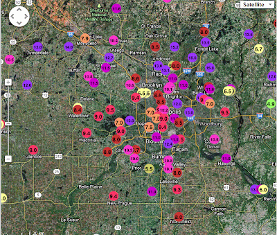
Images (click to enlarge): Snowfall amounts in Minnesota and the Minneapolis region, December 8-9, from National Weather Service

December 14 Update: The average temperature at Minneapolis for the first 2 weeks of December is 7.2° warmer than normal. Only 2 days so far have been colder than average. See here for more on this developing Ice Age.

December 10, 10 AM Update:
The final total for Minneapolis was 10.5".

St. Cloud also set records for both snowfall and precipitation:
A RECORD SNOWFALL OF 11 INCH(ES) WAS SET AT ST CLOUD MN YESTERDAY.   
THIS BREAKS THE OLD RECORD OF 5.1 SET IN 1961.  

A RECORD RAINFALL OF 0.87 INCH(ES) WAS SET AT ST CLOUD MN YESTERDAY.   
THIS BREAKS THE OLD RECORD OF 0.36 SET IN 1899. 
Elsewhere in Minnesota and South Dakota:
A TOTAL OF 0.35 INCHES OF LIQUID PRECIPITATION WAS RECORDED AT THE   
ROCHESTER INTERNATIONAL AIRPORT YESTERDAY...DECEMBER 9TH. THIS   
BREAKS THE PREVIOUS DAILY PRECIPITATION RECORD OF 0.31 INCHES THAT   
WAS SET ON THIS DATE IN 2009.  

SNOWFALL IN HURON SOUTH DAKOTA YESTERDAY...DECEMBER 8TH...TOTALED   
6.5 INCHES. THIS BREAKS THE OLD RECORD DAILY SNOWFALL OF 3.6 INCHES   
SET BACK IN 2008.  
  
THE WATER EQUIVALENT OF 0.52 INCHES ALSO BREAKS THE RECORD DAILY   
RAINFALL FOR DECEMBER 8TH. THE PREVIOUS RECORD WAS 0.38 INCHES...   
ALSO SET IN 2008.  
Original post:
The snowfall at Minneapolis today has set a record for December 9. From the National Weather Service:
A RECORD SNOWFALL OF 10.2 INCH(ES) WAS SET AT TWIN CITIES MN TODAY.
THIS BREAKS THE OLD RECORD OF 7.4 SET IN 1961. 
The all-time record December snowstorm at Minneapolis was 17.1" on Dec. 10-11 2010. That was the 5th largest snowstorm for any month:
1. OCT 31-NOV 3 1991 28.4  
2. NOV 29-DEC 1 1985 21.1  
3. JAN 22-23 1982 .. 20.0
4. JAN 20-21 1982 .. 17.4 
5. DEC 10-11 2010 .. 17.1  
6. NOV 11-12 1940 .. 16.8 
So far this month, the Minneapolis temperature has been 11.2° above average.

Thursday, November 8, 2012

November Snowfall Records Broken in New York Area;
Earliest 4"+ at Central Park


As noted here previously, measurable snowfall has been observed as early as late August, September, and October in the interior of the Northeast during the 19th century, but yesterday's storm set November snowfall records at several locations in the New York region. The National Weather Service reports:
A RECORD SNOWFALL OF 4.3 INCHES WAS SET AT CENTRAL PARK NY   
YESTERDAY. THIS BREAKS THE OLD RECORD OF 0.1 SET IN 1878.  

A RECORD NOVEMBER SINGLE STORM SNOWFALL OF 4.3 INCHES WAS SET AT   
KENNEDY NY ON NOVEMBER 7 AND NOVEMBER 8 2012. THIS BREAKS THE OLD   
NOVEMBER SINGLE STORM SNOWFALL OF 3.7 INCHES SET ON NOVEMBER 22   
AND NOVEMBER 23 IN 1989.  

A RECORD SNOWFALL OF 4.0 INCHES WAS SET AT KENNEDY NY YESTERDAY. THIS IS   
THE FIRST TIME SNOWFALL HAS BEEN RECORDED ON THIS DATE.  
  
A RECORD SNOWFALL OF 1.1 INCHES WAS SET AT LAGUARDIA NY YESTERDAY. THIS   
IS THE FIRST TIME SNOWFALL HAS BEEN RECORDED ON THIS DATE.  
 
A RECORD SNOWFALL OF 1.7 INCHES WAS SET AT ISLIP NY YESTERDAY. THIS IS   
THE FIRST TIME SNOWFALL HAS BEEN RECORDED ON THIS DATE.  

A RECORD NOVEMBER SINGLE STORM SNOWFALL OF 6.2 INCHES WAS SET AT   
NEWARK NJ ON NOVEMBER 7 AND NOVEMBER 8 2012. THIS BREAKS THE OLD   
NOVEMBER SINGLE STORM SNOWFALL OF 5.7 INCHES SET ON NOVEMBER 22   
AND NOVEMBER 23 IN 1989.  

A RECORD SNOWFALL OF 5.7 INCHES WAS SET AT NEWARK NJ YESTERDAY. THIS   
BREAKS THE OLD RECORD OF A TRACE SET IN 1981.  

A RECORD NOVEMBER SINGLE STORM SNOWFALL OF 8.3 INCHES WAS SET AT   
BRIDGEPORT CT ON NOVEMBER 7 AND NOVEMBER 8 2012. THIS BREAKS THE OLD   
NOVEMBER SINGLE STORM SNOWFALL OF 6.6 INCHES SET ON NOVEMBER 22 AND   
NOVEMBER 23 IN 1989.  

A RECORD SNOWFALL OF 6.0 INCHES WAS SET AT BRIDGEPORT CT YESTERDAY.   
THIS BREAKS THE OLD RECORD OF 2.0 SET IN 1953.  
According to unofficial National Weather Service records, this is the earliest 4" snowfall at Central Park since records began there in 1869. The previous record was the 4.4" over 2 weeks later on the 23rd in 1989.


Monday, September 24, 2012

Earliest Measureable Snowfall in 17 Years at Duluth

September 30 Update: Through yesterday, the monthly temperature at Duluth was 0.5° above average. Today's average of +5° (through 5 pm local time) will raise the monthly average by another 0.1-0.2°.

Original post:
The National Service reports on the early snowfall Friday at Duluth, Minnesota:

0.1 inches of snow fell in the late evening hours of Friday, September 21, 2012 at Duluth. This is the earliest snowfall of the season in 17 years. On September 21, 1995, 0.1 of snow fell on that day also.
International Falls reported a trace of snow. The record 24-hour snowfall for September at Duluth was 2.4" on the 18th in 1991.

Through the first 22 days, September's temperature has averaged 1.0° above climatology at Duluth.

Monday, April 9, 2012

Snowiest Season in Anchorage

Image (click to enlarge): Anchorage snowfall through April 9, 2012, from National Weather Service

9 PM Update: Updated chart through April 9.

Original post:
As of Saturday evening, Anchorage, Alaska set a new seasonal snowfall record with 134.5". From the National Weather Service:
PUBLIC INFORMATION STATEMENT
NATIONAL WEATHER SERVICE ANCHORAGE AK
740 PM AKDT SAT APR 7 2012

UPDATED WITH LATEST SNOW TOTAL

...ANCHORAGE SETS NEW SEASONAL SNOWFALL RECORD...

SNOW HAS TAPERED OFF TO FLURRIES AT THE NATIONAL WEATHER SERVICE
FORECAST OFFICE AND NO ADDITIONAL ACCUMULATION IS EXPECTED FROM
THIS STORM. AN ADDITIONAL 0.9 INCHES OF SNOW FELL BETWEEN 4 PM
AND 7 PM WHICH BRINGS THE TOTAL FOR THE DAY TO 4.3 INCHES.

THIS MAKES THE 2011-2012 WINTER SEASON THE SNOWIEST EVER WITH
A TOTAL OF 134.5 INCHES. THE PREVIOUS SEASONAL SNOWFALL RECORD
WAS 132.6 INCHES SET IN 1954-1955.

Thursday, February 9, 2012

SnowFail 2011-12 Update: Midwest Snow Running Nearly 40% Below Average

The Northeast and Mid Atlantic are not the only regions with significant snow deficits at the end of the third quarter of winter 2011-12. National Weather Service reports indicate that the Midwest is averaging 40% below the normal snowfall season-to-date. Of the 43 major reporting locations in Minnesota, Wisconsin, Michigan, Iowa, Illinois, Indiana, Ohio, Missouri, and Kentucky, only Ft. Wayne, Indiana has had more snow than the climatological average, by a mere 2.2", or about 11%.

The largest deficit in absolute terms is at Sault Ste. Marie MI, where the current total of 55" is over 3 feet less than the normal amount to date of just over 91". The map of snow depth on the ground for central and northern Michigan as of February 4 shows deficits of 2 feet or more in the Upper Peninsula. Temperatures at Sault Ste. Marie have been well above normal for all 3 winter months (December +3.8°, January +6.0°, February to date +13.1°).

Percentage-wise, the less than 1" at Kansas City MO is 94% below average. The weighted average deficit across all reporting stations is 39%.

The stations shown in the charts are:
DLH Duluth MN
MSP Minneapolis MN
STC St. Cloud MN
RST Rochester MN
LSE La Crosse WI
EAU Eau Claire WI
MSN Madison WI
AUW Wausau WI
GRB Green Bay WI
ANJ Sault Ste. Marie MI
APN Alpena MI
HTL Houghton Lake MI
MQT Marquette MI
DTW Detroit MI
FNT Flint MI
GRR Grand Rapids MI
LAN Lansing MI
MKG Muskegon MI
ALO Waterloo IA
DSM Des Moines IA
MCW Mason City IA
SUX Sioux City IA
DBQ Dubuque IA
MLI Moline IL
ORD Chicago IL
RFD Rockford IL
PIA Peoria IL
IND Indianapolis IN
FWA Ft. Wayne IN
CMH Columbus OH
CAK Akron OH
MFD Mansfield OH
TOL Toledo OH
YNG Youngstown OH
DAY Dayton OH
CLE Cleveland OH
COU Columbia MO
STL St. Louis MO
MCI Kansas City MO
BWG Bowling Green KY
LEX Lexington KY
SDF Louisville KY
JKL Jackson KY
Images (click to enlarge): Total winter snowfall to date vs. average, snowfall deficit in inches, and snowfall percentage deficit; all data from December 1, 2011 through February 7, 2012 from National Weather Service, charts by CapitalClimate; Michigan snow depth on ground departure from average, February 4, 2012, from National Weather Service

Saturday, February 4, 2012

Denver Breaks All-Time February 1-Day and 3-Day Snowfall Records


The National Weather Service reports that the heavy snowfall through this morning at Denver has set new 1-day and 3-day records for February:
12.5 INCHES OF SNOW FELL AT DENVER INTERNATIONAL AIRPORT ON FEBRUARY
3RD 2012. THIS ESTABLISHES A NEW SNOWFALL RECORD FOR THE DATE. THE
OLD RECORD WAS 7.5 INCHES SET BACK IN 1932. THE 12.5 INCHES THAT
FELL ALSO ESTABLISHED A DAILY SNOWFALL RECORD FOR THE MONTH OF
FEBRUARY. THE PREVIOUS DAILY SNOWFALL RECORD FOR FEBRUARY WAS 9.5
INCHES ON FEBRUARY 22ND 1909 AND FEBRUARY 19TH 1953.

IN ADDITION...FROM THE EVENING OF THE 2ND THROUGH THE MORNING OF THE
4TH...15.9 INCHES OF SNOW FELL AT DENVER INTERNATIONAL AIRPORT. THIS
ESTABLISHES A NEW THREE DAY SNOWFALL TOTAL FOR THE MONTH OF
FEBRUARY. THE OLD RECORD OF 14.1 INCHES OCCURRED BACK IN 1912.
Denver climate history began in 1872. The average temperature for the first 3 days of February at Denver is 2.5° above normal. Since Denver generally has its heaviest late-season snows in March, this could be considered an early spring storm.

Preliminary reports from the National Climatic Data Center show 27 daily snowfall records set on February 3, nearly all in Colorado.

Image (click to enlarge): Snowfall totals in the Denver region, February 2-4, 2012, from National Weather Service

Monday, October 31, 2011

More October Snowfall Records Reported

Image (click to enlarge): October daily snowfall records broken ("X") or tied on October 30, 2011, from National Climatic Data Center

The number of all-time October daily snowfall records set on October 29 has now increased to 27. In addition to the records previously reported are the following (previous record in parentheses):
Hartford CT     12.3" (1.7", 1979-10-10)
Bridgeport CT 3.5" (0.5", 1987-10-04)
Worcester MA 11.4" (7.5", 1979-10-10)
Concord NH 13.6" (2.1", 1969-10-22)
An additional 69 records were reported broken yesterday (October 30). These were primarily cooperative reporting stations, but the official station at Portland, Maine reported a new record of 5.2", vs. the old record of 3.6" (1969-10-22) in a 91-year snowfall history.

Sunday, October 30, 2011

October Snow: Historical Context

The current October snowfall in the northeastern U.S. has certainly been impressive, particularly in the areal extent, but the historical record shows that autumn snowstorms were both earlier and more frequent in the mid-19th century. In his definitive history, "Early American Winters", David Ludlum lists records of early season snowfalls in 21 of the 50 years from 1821 to 1870, including many in September and several in late August. The mid-1830's were particularly prolific, with 3 events before the middle of October in 1836, including at least "some snow" as far south as South Carolina.

1821: Oct. 25-26, Salem MA: "sufficient to cover the ground"

1823: Sept. 29, Worcester County MA: "snow in several parts of the county"

1829: Sept. 3, Sherburne VT: "an inch and a half deep"

1832: Aug. 25-26, New Hampshire: "White Mountains covered by snow apparently several inches deep"

1833: Oct. 30, Somerset PA: "Two inches snow, the fourth fall of the autumn"
Oct. 29-30, Philadelphia PA: "Houses whitened by snow"

1835: Sept. 30, northern New England: 6-12" in Franklin County, Vermont; 6" at Kilkenny New Hampshire

1836: Sept. 28: Hamilton NY 4", Bridgewater NY 3", Rochester NY 1"
October 5-6: Onondaga County NY 2 feet, Auburn NY 24-26" Cortland NY 18", Hollidaysburg PA 26", Sideling Hills MD 10", Loudoun County VA 5", Yorkville SC "some snow"
October 11-12: Hamilton NY 35" "measured as it fell", Madison NY 12", Bridgewater NY 18", Oxford NY 12"

[More reports to be added later]

Early-Season Snow Sets Mid-Atlantic October Records

Image (click to enlarge): Storm total snowfall ending 10 am EDT, October 30, 2011, from National Weather Service


October 31 Update: Snow totals updated with final reports from National Weather Service. The highest reported amount was 32" at Peru, Massachusetts.

11 AM Update: The Weather Channel is reporting via tweet that Jaffrey NH had a storm total of 31.4". A National Weather Service report has increased the Plainfield MA amount to 30.8".

Original Post:
What was little more than a very heavy frost in the Washington, DC metro area yesterday set some all-time October daily snowfall records at higher elevations and north of the Mason-Dixon line. Preliminary data indicate that 20 October daily records were set from West Virginia through New York. Among the major reporting locations, New York's Central Park had the longest period of record (135 years), with the 2.9" smashing the previous record of 0.8" on October 30, 1925. It was therefore the first time that over 1" of snow had been observed in Central Park in October. Other October daily records included (previous record in parentheses):
Newark NJ       5.2" (0.3", 1952-10-20)
La Guardia NY 1.7" (1.2", 1962-10-26)
Kennedy NY 1.5" (Trace, 2002-10-30)
Islip NY 0.3" (0.0")
Harrisburg PA 9.7" (Trace, 1965-10-28)
Wilkes-Barre PA 9.1" (4.4", 1962-10-26)
Allentown PA 6.8" (1.2", 1972-10-19)
The largest amounts of snow from this storm were in the Berkshires of western Massachusetts, where totals of 2 feet or more were reported; the highest was 27.8" at Plainfield. The highest amounts reported by the National Weather Service by state through Sunday, October 30, included:
...CONNECTICUT...
BAKERSVILLE 18.6
WINSTED 18.0
DANBURY 17.2
BRISTOL 17.0
LITCHFIELD 16.5
RIDGEFIELD 15.5
THOMASTON 13.5
WINCHESTER CENTER 13.5
NEW PRESTON 12.8
OXFORD 12.3
NORTH CANAAN 12.0

...MASSACHUSETTS...
PERU 32.0
PLAINFIELD 30.8
WINDSOR 26.0
ASHFIELD 25.5
GOSHEN 25.0
TOLLAND 2 S 25.0
BUCKLAND 24.0
HEATH 24.0
SAVOY 24.0
WORTHINGTON 24.0
TYRINGHAM 23.0
BECKET 5.6 SSW 22.6
BLANDFORD 22.0
LEYDEN 22.0
ROYALSTON 22.0
TEMPLETON 22.0
WASHINGTON 22.0
WORCESTER 14.6
BOSTON 1.0

...MARYLAND...
FROSTBURG 1 N 11.6
SABILLASVILLE 11.5
FROSTBURG 9.5
THURMONT 6 W 8.5
ELDERSBURG 2 NW 7.8
SMITHSBURG 3 NE 7.3
MANCHESTER 5 NW 7.0
REDHOUSE 7.0
WOLFSVILLE 7.0
WOODLAND 1 W 7.0

...MAINE...
ACTION 1 N 20.0
BRIDGTON 17.4
NEWFIELD 4.0 WSW 17.0
CORNISH 1 SSW 14.8
OTISFIELD 1 W 14.0
GRAY NWS OFFICE 12.9
PARIS 4 E 12.0
S CASCO 11.0
WATERVILLE 2.5 NNE 11.0
HOLLIS 9.8
VAUGHAN WOODS 2 ESE 9.0
PORTLAND 5.1 NW 6.5

...NEW HAMPSHIRE...
JAFFREY 31.4
BOW 1.6 NW 25.8
TROY 25.0
PETERBOROUGH 24.0
WEST SWANZEY 24.0
FITZWILLIAM 23.0
CONCORD ASOS 22.2
HILLSBORO 21.5
BEDFORD 20.8
GILFORD 3 SSE 20.0
WASHINGTON 1 ESE 19.5
NORTHFIELD 19.1
MERRIMACK 19.0
NORTH PEMBROKE 2 E 19.0

...NEW JERSEY...
WEST MILFORD 19.0
LAKE HOPATCONG 17.0
SPARTA 16.8
ROCKAWAY TWP 0.7 NE 16.6
MARCELLA 16.4
ROCKAWAY 16.4
LONG VALLEY 16.0
RANDOLPH TWP 0.8 W 14.5
HARDYSTON TWP 3.2 SE 14.1
NEWARK 5.2

...NEW YORK...
MILLBROOK 21.6
BLOOMINGBURG 2 SW 17.7
YANKEE LAKE 16.5
HARRIMAN 16.0
HOPEWELL JUNCTION 2.4 SSE 14.8
WOODRIDGE 5.5 S 13.6
TAGHKANIC 13.1
COPAKE FALLS 13.0
ARMONK 12.5
MILLWOOD 12.4
HIGHLAND MILLS 12.0
KENT CLIFFS 12.0
MIDDLETOWN 12.0
MONROE 12.0
SOMERS 12.0
ALBANY 1 SW 3.8
NEW YORK CENTRAL PARK 2.9

...PENNSYLVANIA...
HAZLETON 1 E 16.0
HUFFS CHURCH 16.0
SPRINGTOWN 16.0
FREELAND 1 S 14.0
TOBYHANNA 13.3
MOSCOW 13.0
WILLIAMS TWP 13.0
ARENDTSVILLE 6 NW 12.5
TOWAMENSING TWP 12.5
LAUREL SUMMIT 12.2
ALBRIGHTSVILLE 12.0
BLUE KNOB 12.0
FAYETTEVILLE 6 ENE 12.0
PHILADELPHIA 0.3

...RHODE ISLAND...
WEST GLOCESTER 6.6
NORTH FOSTER 6.5

BURRILLVILLE 4.5
GREENVILLE 4.0

...VIRGINIA...
SKYLAND 9.0
BIG MEADOWS 8.0
LINDEN 2 N 8.0
WILDE ACRES 1 N 7.4
BETHEL 2 ESE 6.5
CEDAR GROVE 2 NE 6.0
FRONT ROYAL 5.6
WINCHESTER 5.0

...VERMONT...
WEST HALIFAX 0.2 SE 16.0
BRATTLEBORO 2.0 SW 15.1
WILMINGTON 13.0
SPRINGFIELD 9.5
LUDLOW 7.0
WOODSTOCK 6.0

...WEST VIRGINIA...
MOUNT STORM 2 SSE 14.0
KIRBY 4 WNW 12.0
CHERRY GROVE 6 WSW 10.0
MOUNT PISGAH 2 E 10.0
TERRA ALTA 10.0
BLOOMERY 1 SW 8.0
FRANKLIN 4 W 8.0
SMITH CROSSROADS 1 W 7.3
CORTLAND 2 SW 6.5
ROMNEY 4 E 6.4

Tuesday, August 16, 2011

New Zealand Snow: Once in 50 Year Event

August 17 Update: From WeatherWatch:
In Christchurch some snow is falling off and on across the city with heavier falls well inland. Weather analyst Richard Green says there have been a few power outages too across Canterbury as a result of the snow.

WeatherWatch.co.nz says the temperature right now in Christchurch is 2 degrees with a wind chill of minus 4.

But, despite the snow flakes, conditions are generally improving.

The intensity of the showers has significantly eased across more than 80% of New Zealand and while sleet and rain/snow showers are continuing to affect some coastal parts of Canterbury the centre of the storm is moving away.

Head weather analyst Philip Duncan says the centre of the low is now 2500kms south east of Christchurch and moving eastwards away from New Zealand. He says a secondary low will form just east of the Chatham Islands tomorrow causing conditions to linger a little longer. "The main event has well and truly passed now but we're still being affected by the tail end, so more heavy snow down to a few hundred metres from Canterbury to Hawkes Bay and wintry, sleety, conditions to sea level".

He says the secondary low won't add too much more to the weather here but will just keep "today's weather in place until Thursday".

In Wellington the snow level has lifted but a gale force southerly continues to blast through. It's currently 7 degrees with a feels like temperature of zero in the wind.

In Auckland a thin veil of high cloud and a fairly light southerly are the only signs that a winter storm was nearby.

Similar weather is expected tomorrow across New Zealand with significant improvements spreading into more regions by Friday.

By the weekend the large high partially responsible for the winter blast will move in and settle across New Zealand for the first half of next week.

WeatherWatch.co.nz says by the end of next week temperatures will be back to average or even above average if a warm northerly air stream from the sub-tropics eventuates. This is currently being predicted by some long range models - we'll keep you posted!

Original post:
A very strong outbreak of Antarctic air, which began moving into New Zealand on Sunday, has produced unusually widespread snowfall which the official New Zealand MetService has called a once-in-50-year event. The influx of a deep layer of cold air flowing almost directly from the Antarctic continent over much warmer sea water allowed the development of heavy "ocean effect" snow showers.

The weather map to the right shows a very strong 1034 mb high pressure area pumping cold air counter-clockwise from Antarctica to New Zealand. (New Zealand is located in the lower left of the map, with the high centered to the south. Antarctica is near the center of the lower part of the map.) The red line on the lower map shows the trajectory of air arriving at Auckland on August 15.

The 3 to 5 cm. of snow which fell above an elevation of 100 meters for at least an hour late Sunday afternoon was characterized as the "heaviest and most widespread snowfall in Wellington City for at least 30 50 years." Wellington is located on the southern end of North Island.

Although temperatures have been cold for this event, they have not been widely extreme. The 8.1°C high at Auckland Airport on Monday was an all-time record low maximum, but official climate data began there only in 1966. The 4.6°C at Christchurch Airport, by contrast, was exceeded in July 2007. At Waiouru, elevation about 2700 feet, the Monday low of -7.7°C was a new monthly record for August.

According to WeatherWatch,
[H]eavy snow is likely to set in again across Wellington tonight as the snow returns to the city this afternoon.

The late afternoon surge, which WeatherWatch.co.nz predicted this morning, has seen the temperature plunge to 1 degree with a wind chill of -5.

Head weather analyst Philip Duncan says the snow will spread across the lower North Island again but may not affect quite so many main centres to the north west of the city. "Snow is expected to be heavy around Wellington, Upper Hutt and Wairarapa tonight with a moderate risk of snow flakes returning to low levels of the lower North Island like Wanganui and Taranaki".

Mr Duncan says the heavy snow in Wellington is likely to come and go all night with snow easing tomorrow morning. Snow will move into Hawkes Bay and Gisborne region too, to 100 or 200 metres.

Meanwhile Christchurch and other coastal parts of Canterbury could see more snow tonight. Weather analyst Richard Green says snow showers may return to the city tonight, but should ease in the early hours of Wednesday. Snow isn't expected to be as heavy as it was yesterday with passing snow flurries. However he says the city is definitely 50/50 for snow. "The freezing level has lifted just enough so that Christchurch, Timaru and Ashburton are all on the borderline of snow. It's an extremely fine line between sleet, rain and snow for those centres tonight but we don't expect the falls to be long lasting and heavy as they were last night".

Snow has already started to melt and turn to slush with rain showers and sleet today in the garden city.

In Dunedin a few brief snow flurries are possible but conditions there should be easing further as we head into Wednesday.

And Auckland's chance of seeing snow is quickly fading. A large shower this afternoon saw graupel and sleet in some areas while snow was confirmed on the tops of the Waitakere Ranges this morning in to around 300m from a passing snow shower.
See the New Zealand Herald for a video gallery of the snow in Christchurch.

Images (click to enlarge):
- Snow in Clifford Road, Johnsonville (altitude approximately 200 metres) early evening, Sunday 14 August 2011; from New Zealand MetService
- New Zealand snowfall extent from Sunday, August 14 through 2 pm Tuesday, August 16; from New Zealand MetService
- Southern Pacific Ocean sea-level pressure analysis at 10 am, August 15; from Australian Bureau of Meteorology
- Backward-projected trajectory of air parcel at 500 meters above sea level arriving at Auckland, New Zealand, midday Monday, August 15; from NOAA Air Resources Laboratory via New Zealand MetService

Tuesday, April 19, 2011

Record Late Snowfall in Green Bay


April 20 Update: The final daily snowfall total for Green Bay was 9.9".

For the ICE AGERS: Some temperature context for this event:

Despite the unseasonable cold of the last few days, the month of April so far has been within 0.7° of the long-term average in Green Bay. On the other hand, the month-to-date precipitation of 3.92" is slightly under 2.5 times the average amount. The season-to-date total of 7.00" is also almost double the average.

Here are some other month-to-date temperature departures from around the rest of Wisconsin:
Oshkosh    +1.5
Wausau -0.6
La Crosse +1.8
Madison +2.6
Marquette +1.6
Milwaukee +0.5
These daily snowfall records for April 19 were also set:
 CITY           SNOWFALL(IN)     OLD RECORD(IN)     YEAR

GREEN BAY(NWS) 9.9 1.5 1898
APPLETON 9.4 0.5 1924...1928
WISCONSIN RAPIDS 6.0 0.5 1982
STURGEON BAY 5.0 2.0 1925...1993
OSHKOSH 4.6 0.2 1953
STEVENS POINT 4.0 T 1914...1922
WAUSAU 1.9 1.5 1898
MERRILL 0.9 0.8 1928
The top 5 seasonal snowfall totals at Green Bay are:
RANK    SNOWFALL       YEARS
1 147.7 INCHES 1887/88
2 103.6 INCHES 1889/90
3 92.4 INCHES 2010/11 [through April 19]
4 87.7 INCHES 2008/09
5 87.4 INCHES 2007/08
Original post:
The National Weather Service reports that today's snowfall at Green Bay, Wisconsin has set a record for so late in the season:
AS OF 9 PM THIS EVENING...8.7 INCHES OF SNOW HAD FALLEN IN GREEN BAY.

THIS IS THE GREATEST DAILY SNOWFALL EVER SO LATE IN THE SEASON.

TODAY`S SNOWFALL BRINGS THE SEASONAL TOTAL TO 91.2 INCHES...WHICH
IS THE THIRD GREATEST SEASONAL TOTAL EVER IN GREEN BAY...AND THE
MOST SINCE THE WINTER OF 1889-1890.
This exceeds by half an inch the 8.2" which fell 4 days later in the month on April 23, 1910. Measurable snow has fallen as late as May 28, when 3" fell in 1947 at Green Bay.

Daily records were also set or tied at Milwaukee and Madison:
A RECORD SNOWFALL OF A TRACE WAS SET AT MILWAUKEE WI ON APRIL 19.
THIS TIES THE OLD RECORD OF A TRACE SET IN 1990.

A RECORD PRECIPITATION OF 1.04 INCHES WAS SET IN MADISON ON
APRIL 19. THE PREVIOUS RECORD WAS 0.93 INCHES IN 1993.

A RECORD SNOWFALL OF 1.3 INCHES WAS SET IN MADISON ON APRIL 19.
THE PREVIOUS SNOWFALL RECORD OF 0.3 INCHES WAS SET IN 1953.

Saturday, April 16, 2011

Minneapolis Snowfall Update: Fourth Highest Total


April 20 Update: Today's 1.3" brings the Minneapolis seasonal snowfall total to 86.6". This is still the 4th highest seasonal total. The spring total to date (since March 1) of 10.1" is 24% below the long-term average.

Image (click to enlarge): Minnesota/Wisconsin 24-hour snowfall ending at 9 am CDT, April 20, from National Weather Service

Original post:
Yesterday's 0.6" of snow at Minneapolis brought the 2010-2011 snowfall total to 85.3". That was just enough to edge past 1916-1917 into 4th place. An additional 3.7" would be necessary to exceed the 3rd highest season of 1950-1951. Although measurable snow as late as May is hardly unheard-of in Minneapolis, time is running out on the chances for further record setting. The top 10 May snowfall totals are:
                 3.0...1892/1935/1946  
2.4...1954
2.0...1915
1.8...1909
1.2...1976
1.0...1885/1888
0.8...1907
0.5...1923/24
0.3...1967/91
0.2...1929/47/71
For previous posts on Minneapolis snowfall, see:

Thursday, March 31, 2011

Near-Record April Fool's Snowfall Forecast
Update: Bangor Sets Record

Images (click to enlarge): Snowfall forecast for April 1 from The Weather Channel; Daily snowfall ending 8 am EDT, April 2, from National Weather Service/NOAA

April 2 Update: The final total of 14.4" at Bangor exceeded the April daily record (see list below) by 4". Other updated totals:
Gray ME     10.3"
Caribou ME 7.5"
The Lewiston Sun-Journal reported these additional amounts:
Hope     13.5"
Raymond 11"
Oxford 11"
Lewiston 10.3"
Turner 9"
Auburn 8"
6 PM Update: The preliminary snowfall total of 10.5" at Bangor exceeds the daily record of 8.5" in 1993 and is also a new all-time daily record for April; the old record was 10.4" on 4/13/1962.

Other daily totals:
Concord NH      4.9"           
Portland ME 5.9"
Gray ME 9.6"
Caribou ME 1.3"
Hartford CT 1.3"
Boston MA 0.9"
Worcester MA 3.8"
April 1, 1 PM update: Snowfall amounts appear to be on track with the forecast in Maine and New Hampshire, with 6"-8" reported by late morning. The National Weather Service reports:
STORM TOTAL SNOW AMOUNTS STILL LOOK ON TRACK TO REACH FORECAST  
LEVELS. REPORTS SO FAR HAVE INDICATED 6 TO 8 INCHES HAS FALLEN IN
SOUTHEAST NEW HAMPSHIRE AND SOUTHWEST MAINE. LOCATIONS ALONG THE
MIDCOAST AND FROM LEWISTON TO AUGUSTA MAY BE THE BIG WINNERS FROM
THIS STORM AS HEAVY SNOW CONTINUES FOR ANOTHER COUPLE OF HOURS
THERE. TOTAL AMOUNTS IN EXCESS OF 12 INCHES ARE POSSIBLE.

BIGGEST THREAT FROM THIS HEAVY WET SNOW IS THE SLUSHY ACCUMULATION
ON ROADWAYS THAT IS VERY SLICK FOR DRIVING. HAVE HAD REPORTS OF
MANY ACCIDENTS THIS MORNING. ALSO HAVE SEEN ACCUMULATIONS ON TREES
LEADING TO LIMBS SNAPPING AND CAUSING POWER OUTAGES.
Original post:
With widespread snowfall amounts of 8"-12" forecast for interior northern New England, some April snow records may be exceeded. Here are some top 10 April 1-day snowfalls for New Hampshire and Maine from NOAA:
Concord NH
Years: 1903-2011
Rank Value Ending Date
1 15.0 4/13/1933
2 13.3 4/6/1982
3 8.6 4/10/1996
4 8.4 4/4/2003
5 8.3 4/8/1931
6 6.8 4/8/1956
7 6.6 4/12/1918
8 6.2 4/9/1907
9 5.7 4/1/1993
10 5.6 4/7/1971

Berlin NH
Years: 1886-2011
Rank Value Ending Date
1 14.0 4/13/1933
2 13.0 4/4/1975
3 11.0 4/7/1982
4 10.0 4/29/1987
5 9.0 4/5/2007, 4/2/1987
7 8.5 4/1/1922
8 8.0 4/28/2010, 4/11/1996, 4/10/1974

Portland ME
Years: 1871-2011
Rank Value Ending Date
1 15.0 4/10/1906
2 14.0 4/6/1982
3 12.5 4/2/1887
4 11.4 4/13/1933
5 11.1 4/1/1922
6 10.6 4/1/1993
7 8.7 4/7/1971
8 8.0 4/16/1904
9 7.6 4/2/1924
10 7.5 4/19/1925

Augusta ME
Years: 1948-2009
Rank Value Ending Date
1 10.7 4/10/1996
2 9.0 4/6/1982, 4/3/1975
4 6.7 4/16/1988
5 6.6 4/1/1985, 4/13/1972
7 6.2 4/29/1958, 4/9/1957
9 6.0 4/25/1962, 4/13/1962

Bangor ME
Years: 1926-2011
Rank Value Ending Date
1 10.4 4/13/1962
2 10.0 4/3/1975
3 9.4 4/7/1982
4 9.0 4/5/2007
5 8.5 4/1/1993
6 8.3 4/9/1957
7 7.4 4/3/1964
8 6.2 4/1/1985
9 6.0 4/4/2007, 4/9/1938

Caribou ME
Years: 1939-2011
Rank Value Ending Date
1 21.1 4/7/1982
2 10.3 4/13/2007
3 9.9 4/5/2007
4 9.6 4/5/1973
5 8.2 4/2/1970
6 7.6 4/10/1973
7 7.4 4/10/1996
8 7.2 4/11/1961
9 7.0 4/11/1990
10 6.4 4/18/1953

Wednesday, March 23, 2011

Minneapolis Snowfall Update: Sixth Fifth Snowiest Season

March 24 Update: The 84.7" Minneapolis seasonal snowfall to date is confirmed.

Midnight CDT Update: An unofficially final amount of 4.1" for March 23 leaves the Minneapolis seasonal snowfall total at 84.7", still in 5th place, but just 0.2" behind 1916-17.

5 PM CDT Update: Snow ended at 4:08 pm with only a trace of precipitation since 1:00, so the total of 84.6" is likely to hold.

3 PM CDT Update: An additional 1" which had apparently been recorded earlier raises the total to 84.6", putting the seasonal snowfall in 5th place if confirmed. Further accumulation of up to 1" is forecast through 7 pm. An amount of 0.4" or more would be enough to reach 4th place.

Original post:
Minneapolis is reporting 3" of snow in the last 6 hours as of 1 pm CDT. Combined with the 0.4" reported yesterday, this brings the seasonal total unofficially to 83.6". That amount would put this season in 6th place, behind the 1991-1992 amount of 84.1". Light snow is continuing, although visibility has increased substantially during the past hour.

Monday, March 7, 2011

Record Moisture Fuels Massive Northeast Snowfall;
Update: Precipitation Records Smashed from DC to New England


6 PM Update: The 1.17" of precipitation at Burlington today exceeded the old record of 0.91" in 1922 by 30%. Burlington climate records began in 1884. The 1.09" which fell yesterday was only slightly short of the record 1.17" set in 1920.

Although Concord, New Hampshire had only a trace of snow, the precipitation of 1.50" broke by almost 50% the old record for March 7 of 1.03" set in 1926. Concord climate records date back to 1871.

Portland, Maine also had a trace of snow, but the 2.09" of precipitation beat the old record of 1.56" set in 1923.

Hartford's 1.50" broke the old record of 1.39" set in 1967; records began 1904. Hartford also had 2.22" the previous day; the record is 2.48" in 1979.

Watertown, New York set a record of 0.92" on Saturday (March 5).

Buffalo also set a record on the 5th with 1.33", drowning the old record of 0.79 set in 1996; records began in 1871.

The 1.73" at Avoca, Pennsylvania yesterday was almost 60% above the old record of 1.13" in 1916; records began in 1901.

Binghamton, New York set a record yesterday with 1.25", nearly doubling the old record of 0.69" in 1956.

Islip, New York set a record of 0.79", beating the old record of 0.64" in 1989. However, Islip records only began in 1986.

The 1.82" at Allentown, Pennsylvania broke the old record of 1.60" set in 1967; records began in 1922.

Mt. Pocono, Pennsylvania set a new record with 2.50", nearly an inch above the old record of 1.59" from 1943; records began in 1901.

Williamsport, Pennsylvania's 1.78" broke the old record of 1.30" in 1959; records began in 1895.

The 2.27" at Harrisburg significantly beat the the old record of 1.40" in 1932; records began in 1888.

Trenton, New Jersey set a new record in a climate history dating back almost a century and a half (since 1865) : 1.77" beat the 1.41" in 1943.

The 2.30" at Washington Dulles more than doubled the old record of 1.12" in 1967, although records only began in 1962.

Blacksburg, Virginia had 1.50", which broke the record of 0.88" in 1959; records began in 1952.

Storm total snowfalls below have been updated through 6 pm, EST.

Original post:
Fed by record-setting moisture amounts, snowfall in northeastern New York and Vermont has ranged up to 30" since Sunday. The daily precipitation of 1.87" at Montpelier was almost triple the old record of 0.68" in 1963.

Here are some double-digit snowfall amounts from the National Weather Service:
********************STORM TOTAL SNOWFALL********************  

LOCATION STORM TOTAL TIME/DATE COMMENTS
SNOWFALL OF
/INCHES/ MEASUREMENT

NEW YORK

..CLINTON COUNTY

PLATTSBURGH 22.0 1100 AM 3/07 CHANNEL 5
MORRISONVILLE 22.0 1100 AM 3/07 PUBLIC

..ESSEX COUNTY

WESTPORT 27.0 930 AM 3/07 SPOTTER
3 N WESTPORT 27.0 911 AM 3/07
1 N LAKE PLACID 23.0 440 PM 3/07 COCORAHS OBSERVER
MORIAH 22.5 909 AM 3/07

..FRANKLIN COUNTY

TUPPER LAKE 29.0 909 AM 3/07 SPOTTER
SARANAC LAKE 29.0 1115 AM 3/07 PUBLIC
CHASM FALLS 26.4 1112 AM 3/07 PUBLIC
WHIPPLEVILLE 17.4 1134 AM 3/07 SPOTTER

VERMONT

..ADDISON COUNTY

BRIDPORT 24.0 100 PM 3/07 SPOTTER
SALISBURY 23.8 541 PM 3/07 PUBLIC
1 WNW ORWELL 23.0 200 PM 3/07 COCORAHS OBSERVER
CORNWALL 22.0 1030 AM 3/07 SPOTTER

..CALEDONIA COUNTY

LYNDONVILLE 21.0 1215 PM 3/07 LYNDON STATE
2 SW SUTTON 19.5 1220 PM 3/07 COOP
ST. JOHNSBURY 17.8 1200 PM 3/07 FAIRBANKS MUSEUM

..CHITTENDEN COUNTY

JERICHO 30.0 1136 AM 3/07 TOWN HIGHWAY
1 ENE NORTH UNDERHIL 26.9 400 PM 3/07 NWS EMPLOYEE
2 NW WESTFORD 26.0 330 PM 3/07 NWS EMPLOYEE
HINESBURG 24.5 400 PM 3/07 PUBLIC
1 NE SOUTH BURLINGTO 24.3 350 PM 3/07 NWS OFFICE
JERICHO CENTER 23.5 1019 AM 3/07 GENERAL PUBLIC
1 ESE NASHVILLE 21.6 110 PM 3/07 NWS EMPLOYEE

..FRANKLIN COUNTY

HIGHGATE CENTER 22.5 400 PM 3/07 PUBLIC
SWANTON 22.2 400 PM 3/07 PUBLIC

..LAMOILLE COUNTY

1 ESE PLEASANT VALLE 30.0 400 PM 3/07 SPOTTER
MORRISVILLE 27.5 458 PM 3/07 PUBLIC
STOWE 27.0 1245 PM 3/07 PUBLIC
3 SSE JEFFERSONVILLE 24.0 542 PM 3/07 COOP OBSERVER
2 ESE NORTH HYDE PAR 24.0 531 PM 3/07 COOP
2 S EDEN 22.0 100 PM 3/07 COOP OBSERVER
8 NW STOWE 16.0 600 PM 3/07 MOUNT MANSFIELD COOP

..ORLEANS COUNTY

1 NE NEWPORT 29.0 430 PM 3/07 COOP OBSERVER
2 WNW STANNARD 18.7 500 PM 3/07 SPOTTER

..WASHINGTON COUNTY

2 NNE WATERBURY CENT 25.5 435 PM 3/07 SPOTTER
1 NW EAST WARREN 22.0 500 PM 3/07
MORETOWN 19.0 1020 AM 3/07 SPOTTER
4 ESE MARSHFIELD 18.5 150 PM 3/07 SPOTTER
CABOT 15.0 1230 PM 3/07 PUBLIC
EAST CALAIS 10.5 929 AM 3/07 GENERAL PUBLIC

Thursday, March 3, 2011

Minneapolis Snowfall Update: Second Snowiest Winter (December-February) on Record


Image (click to enlarge): Top 5 cumulative seasonal snowfalls to date vs. 2010-11 at Minneapolis, from National Weather Service

March 22, 11 PM CDT Update: The total storm snowfall of 4" to 7" expected through Wednesday would bring the season's total to 84"-87". This could raise the current season to as high as 4th snowiest in Minneapolis history. A minimum of 1.2" would be necessary to reach 6th place, 4.0" to reach 5th place, and 4.8" to reach 4th place. (The current total to date is 80.2".)

March 9 Update: An additional 0.8" through this morning brings the seasonal total to 79.5", putting it in 7th place, behind the 1961-1962 amount of 81.3".

March 7, Noon CST Update: The storm total of 2.1" through this morning puts the seasonal total in sole possession of 8th place with 78.7".

March 6, Midnight CST Update: The 1.7" of snow on Sunday brings the seasonal total to 78.3", still 0.1" below 8th place 1966-67.
The top 10 seasons are:
1983-1984   98.6                                         
1981-1982 95.0
1950-1951 88.9
1916-1917 84.9
1991-1992 84.1
1961-1962 81.3
1951-1952 79.0
1966-1967 78.4
2010-2011 78.3
2000-2001 75.8
March 6 Update: The overall snow season at Minneapolis extends beyond the meteorological winter months of December-February. For the entire season, the 76.6" to date is in 9th place. The record amount was 98.6" in 1983-84, so it would require nearly 2 feet more in the remainder of March and April in order to break the seasonal record.

Original post:
The National Weather Service reports that the 66.7" of snow for the 2010-11 meteorological winter (December-February) was the second largest amount on record at Minneapolis. The record snowiest winter was in 1966-67, when 71.7" fell. It was also the 4th wettest winter on record. The 4.91" of precipitation was 173% of normal.

The average winter temperature at Minneapolis was 1.6° below normal. As the 58th coldest winter, it was near the middle of the range for the 140-year climate history of Minneapolis. The average daily high temperature was 3.0° below normal (36th coldest), but the average low was only 0.1° below normal.

St. Cloud had its 4th snowiest winter on record with 47.5" of snow, and the 4.35" of precipitation was also the 4th wettest on record.

Here are the Minneapolis extreme warmest, coldest, wettest, and snowiest winters, from the National Weather Service (HDD denotes heating degree days):
                            EXTREME      YEAR     DEPART            RANK
DEC-JAN-FEB MAX 36.3 1878 11.1 WARMEST 1 WARM
DEC-JAN-FEB MAX 13.3 1875 -11.9 COLDEST 1 COLD
DEC-JAN-FEB MIN 21.6 1878 12.6 WARMEST 1 WARM
DEC-JAN-FEB MIN -5.8 1875 -14.8 COLDEST 1 COLD
DEC-JAN-FEB MEAN 29.0 1878 11.7 WARMEST 1 WARM
DEC-JAN-FEB MEAN 3.8 1875 -13.5 COLDEST 1 COLD
DEC-JAN-FEB HDD 3240 1878 -1077 WARMEST 1 WARM
DEC-JAN-FEB HDD 5471 1875 1154 COLDEST 1 COLD
DEC-JAN-FEB PRECIP 9.58 1881 6.75 SNOWIEST 1 WET
DEC-JAN-FEB PRECIP 0.69 1958 -2.14 DRIEST 1 DRY
DEC-JAN-FEB SNOW 71.7 1967 40.0 WETTER 1 WET
DEC-JAN-FEB SNOW 5.2 1944 -26.5 DRIER 1 DRY

Friday, February 25, 2011

San Francisco Snow? (Would Be) Fifth Occurrence in Last Century
Update: No SFO Snow, 1976 Record Holds

Feb. 28 Update: Other than a few flurries, snow failed to materialize in San Francisco. The National Weather Service reports:
As it turns out, a few showers did linger during the early morning hours of February 26th to allow for snow all the way down to sea level. However, only trace snowfall was reported around San Francisco. Therefore the last measurable snowfall in San Francisco still remains 1976. Farther south toward Monterey, light snowfall dustings were also reported. Higher peaks above approximately 2000 feet received more measurable snowfall with a few inches, which is not unusual for this time of year. The overall airmass remained rather unstable during the afternoon of February 26th which resulted in convective rain and snow showers across the region. Several weather spotters reported snow down to sea level once again, but no accumulation was noted.
1:30 PM PST Update: (Headline modified to clarify event is only a possibility.) The latest forecast discussion from the National Weather Service confirms that measurable snow is unlikely below elevations of 500 feet:
 AFTER THE FRONT MOVES THROUGH THE RAIN WILL TURN TO SHOWERS. THE NORTH BAY
MOUNTAINS COULD GET SEVERAL INCHES OF SNOW LATER THIS MORNING INTO
THE AFTERNOON...BUT THE MAJORITY OF THE PRECIPITATION WILL END BY
LATE AFTERNOON NORTH OF THE GOLDEN GATE. THERE COULD BE LIGHT
RAIN/SNOW SHOWERS TONIGHT...WITH SAN FRANCISCO POSSIBLY SEEING SOME
SNOWFLAKES OVERNIGHT...BUT NO ACCUMULATION IS EXPECTED. LOOKS LIKE
THE MAIN AREA THAT HAS THE BEST CHANCE OF SEEING SIGNIFICANT SNOW
WILL BE THE SANTA CRUZ MOUNTAINS AND THE EAST BAY HILLS SOUTH...AND
SOUTH OF THE SANTA CLARA VALLEY IN THE LOWER ELEVATIONS.
Note to Ice Agers: The average change in temperature with height is 5.38°F/1,000 Ft, more when the air is especially cold aloft as in the current situation, so snowfall in the hills doesn't count for any records.

Meanwhile, very heavy rainfall rates have been reported this morning from the storm. A downpour in northeastern San Francisco recorded 0.11" of rain in 5 minutes, a rate of over 1" per hour. Over 2" were reported in 24 hours west of Cupertino.

Original post:
A strong upper-level low pressure area is bringing cold temperatures to the San Francisco Bay area and prompting the National Weather Service to issue a winter weather advisory for elevations above 1000 feet in the North Bay area:
A WINTER WEATHER ADVISORY REMAINS IN EFFECT UNTIL 4 PM PST
FRIDAY.

* SNOW ACCUMULATIONS: 1 INCH 1000 TO 1500 FEET WITH 2 TO 4 INCHES
ABOVE 1500 FEET. 6 INCHES OR MORE FOR ELEVATIONS ABOVE 2500 FEET.

* ELEVATION: HEAVIEST SNOW WILL BE ABOVE 1500 FEET BUT
ACCUMULATING SNOW IS EXPECTED AS LOW AS 1000 FEET.

* TIMING: A MIX OF RAIN AND SNOW WILL CONTINUE THIS EVENING AND
CHANGE TO ALL SNOW OVERNIGHT AS SNOW LEVELS DROP. STEADY PRECIPITATION
WILL CHANGE TO SNOW SHOWERS BY FRIDAY MORNING.
If measurable snow were to occur at sea level, it would be only the 5th such occurrence in the past century, according to Golden Gate Weather Services. Unofficial reports indicate that there were 7 such events in the second half of the 19th century.

H/T: NCAR AtmosNews

Seasonal Outlook

Latest seasonal forecast: Click here.


Latest 3-month temperature outlook from Climate Prediction Center/NWS/NOAA.