Here's a time-lapse video of composite radar images throughout the history of the Washington, DC Derecho on June 29, 2012, from NOAA/NSSL:
Showing posts with label Severe Weather. Show all posts
Showing posts with label Severe Weather. Show all posts
Tuesday, July 3, 2012


Wednesday, March 14, 2012
Earliest 1" Hail in Massachusetts by Over 1 Month
Near and after midnight last night, there were 12 reports of ¾" hail or larger in Worcester, Hampshire, and Middlesex counties in Massachusetts. The largest were 1" measured at Westminster and 1.25" at Littleton. According to the National Climatic Data Center, of the 287 reports of 1" hail or larger in Massacusetts since official records began in 1950, there had never been any previous reports as early as March. The earliest report was on 04/19/1969 in Norfolk County. In fact, of the 825 reports of ¾" hail or larger in the state, none had occurred in March either. The earliest was on 04/06/1982 in Nantucket County. The storm reports, from the National Weather Service:
..TIME...   ...EVENT...      ...CITY LOCATION...     ...LAT.LON...
..DATE...   ....MAG....      ..COUNTY LOCATION..ST.. ...SOURCE....
            ..REMARKS..

1157 PM     HAIL             TEMPLETON               42.56N  72.07W
03/13/2012  M0.88 INCH       WORCESTER          MA   HAM RADIO

1215 AM     HAIL             WESTMINSTER             42.55N  71.90W
03/14/2012  M1.00 INCH       WORCESTER          MA   LAW ENFORCEMENT

            HAIL COVERED THE ROAD

1222 AM     HAIL             GRANBY                  42.26N  72.53W
03/14/2012  M0.75 INCH       HAMPSHIRE          MA   BROADCAST MEDIA

1228 AM     HAIL             GRANBY                  42.26N  72.52W
03/14/2012  M0.88 INCH       HAMPSHIRE          MA   HAM RADIO

1235 AM     HAIL             LEOMINSTER              42.52N  71.76W
03/14/2012  M0.88 INCH       WORCESTER          MA   GENERAL PUBLIC

1242 AM     HAIL             GROTON                  42.61N  71.57W
03/14/2012  M0.75 INCH       MIDDLESEX          MA   BROADCAST MEDIA

1243 AM     HAIL             LUNENBURG               42.59N  71.73W
03/14/2012  M0.88 INCH       WORCESTER          MA   HAM RADIO

1248 AM     HAIL             SHIRLEY                 42.54N  71.65W
03/14/2012  M1.00 INCH       MIDDLESEX          MA   HAM RADIO

1255 AM     HAIL             LITTLETON               42.54N  71.47W
03/14/2012  M0.75 INCH       MIDDLESEX          MA   AMATEUR RADIO

1257 AM     HAIL             LITTLETON               42.54N  71.51W
03/14/2012  M1.25 INCH       MIDDLESEX          MA   HAM RADIO

0120 AM     HAIL             WILMINGTON              42.55N  71.17W
03/14/2012  M0.88 INCH       MIDDLESEX          MA   HAM RADIO

0131 AM     HAIL             NORTH READING           42.58N  71.08W
03/14/2012  M0.75 INCH       MIDDLESEX          MA   HAM RADIO
Tuesday, March 13, 2012
Southeast Michigan Tornado is Earliest So Far North

The National Weather Service reports that an EF-1 tornado on Sunday, March 12, was the earliest so far north in southeastern Michigan since records began in 1950. The tornado southeast of Coleman in Midland County was only the 10th tornado to occur before April 1 in the 17 counties covered by the NWS Detroit office. It was the first to occur north of highway I-69 and is tied with the March 12, 1976 Lenawee County tornado as the earliest in the region. The tornado had a track length of 5.1 miles and a maximum width of 125 yards. The storm report:
..TIME... ...EVENT... ...CITY LOCATION... ...LAT.LON...Image (click to enlarge): Tornado damage near Coleman, Michigan, on March 12, 2012, from NWS
..DATE... ....MAG.... ..COUNTY LOCATION..ST.. ...SOURCE....
..REMARKS..
0643 PM TORNADO 3 SSE COLEMAN 43.71N 84.57W
03/12/2012 EF1 MIDLAND MI EMERGENCY MNGR
EF1 TORNADO WITH WINDS ESTIMATED TO 90 MPH STARTED NEAR
WEINERT AND LEWIS ROADS WHERE A GARAGE WAS DESTOYED. THE
TORNADO MOVED NORTHEST DAMAGING 3 MORE POLE BARNS AND
UPROOTING TREES...ESPECIALLY AROUND ALAMANDO AND MANDO
ROADS AND NEAR THE END OF THE TORNADO PATH AT M-18 AND
SHAFFER ROAD. THE TORNADO PATH WAS 5.1 MILES WITH A
MAXIMUM WIDTH OF 125 YARDS. THE TORNADO ENDED AT 648 PM
EDT.
Friday, March 9, 2012
Kentucky Tornado Upgraded to EF-4; Only Second Equivalent March Storm in State

The National Weather Service late this afternoon upgraded the status of the March 2 tornado near Crittenden and Piner, Kentucky to EF-4. According to National Climatic Data Center records, this is only the second tornado of EF-4/F-4 intensity to occur during March in the state of Kentucky. The previous one, on March 4, 1964 caused 3 deaths and 24 injuries in Calloway and Marshall counties. From the NWS summary:
LOCATION...CRITTENDEN AND PINER IN GRANT AND KENTON COUNTY KENTUCKYImage (click to enlarge): EF-4 tornado track near Crittenden and Piner, Kentucky, March 2, 2012, from National Weather Service
DATE...MARCH 2 2012
ESTIMATED TIME...430 PM EDT
MAXIMUM EF-SCALE RATING...EF4
ESTIMATED MAXIMUM WIND SPEED...175 MPH
MAXIMUM PATH WIDTH...ONE HALF MILE
PATH LENGTH...10 MILES
BEGINNING LAT/LON...38.791N/84.633W
ENDING LAT/LON...38.8324N/84.459W
* FATALITIES...4
* INJURIES...8
IMMEDIATELY AS THE TORNADO CROSSED FROM WEST TO EAST OF INTERSTATE
75...THE STORM STRENGTHENED TO EF4 LEVEL WITH WINDS ESTIMATED AT 175
MPH. WHILE A TOTAL OF FIVE SINGLE FAMILY HOMES WERE DESTROYED TO
THEIR FOUNDATIONS IN THE AREA...AT LEAST TWO OF THESE HOMES MET THE
EF4 CRITERIA OF SUFFICIENT FOUNDATION STRAPPING/BOLTING.
ALL 4 FATALITIES WITH THIS TORNADO OCCURRED WITHIN THE AREA OF EF4
LEVEL DAMAGE.
THE EF4 LEVEL DAMAGE WAS FOUND FROM THE EAST SIDE OF INTERSTATE 75
TO THE NORTH END OF OLD LEXINGTON PIKE...WHERE 2 HOMES AND MULTIPLE
OUTBUILDINGS WERE COMPLETELY DESTROYED. BOTH HOMES WERE BRICK
STRUCTURES WITH FOUNDATION BOLTING OR STRAPPING. THE EF4 LEVEL WINDS
CONTINUED ACROSS ROUTE 25/DIXIE HIGHWAY...AND ENDED NEAR THE BAGBY
ROAD AREA. AT LEAST 2 VEHICLES WERE CARRIED...WITH ONE CARRIED OVER
1800 FEET. TREES WERE STRIPPED OF NEARLY ALL BRANCHES...WITH MUCH OF
THE BARK ALSO STRIPPED.
Monday, March 5, 2012
Indiana/Kentucky Tornado Areas Hit With 4-5" of Snow
Some of the same areas in Indiana and Kentucky hit with strong tornadoes on Friday got 4-5" of snow, with some higher amounts, Sunday night into Monday morning (maps from National Weather Service, click to enlarge):


Southern Indiana EF-4 Tornado Occurred a Month Earlier Than Only Previous Comparable Event

 The National Weather Service reports this evening that the March 2 EF-4 tornado in Washington, Jefferson, and Clark counties in Indiana had a total track length of 49 miles with a maximum path width of as much as half a mile. It appears that this storm, although a month earlier, was at least comparable to the only other recorded event of similar magnitude in that region. The infamous outbreak of April 3-4, 1974, the worst in U.S. history up to that point, was the only previous event with F-4 or stronger tornadoes in those 3 counties since official records began in 1950, according to NOAA/NCDC historical data.
Image (click to enlarge): Track of southern Indiana EF-4 tornado on March 2, 2012, from National Weather Service; Indiana county map from digital-topo-maps.com
Saturday, March 3, 2012
Confirmed EF3 Tornadoes in Eastern Kentucky Strongest Ever Observed in At Least 3 Counties
 The National Weather Service confirmed late this afternoon that the tornado yesterday in Menifee and Morgan Counties was rated EF3. The tornado at Salyersville in Magoffin County was also an EF3. According to the National Climatic Data Center database of storm reports, these are the first EF3 or higher tornadoes ever reported in these 3 counties since official records began in 1950. In fact, only 1 tornado as strong as F1, on 06/02/1990, has been reported in Menifee County. The strongest previous tornado in Morgan County was an F2 on 09/29/1972. Magoffin County has had no previous tornadoes as strong as F1 and only 1 F0.
Image (click to enlarge): Number of tornadoes F2/EF2 or higher intensity by county in eastern Kentucky, 1950-2011, from NWS
March Tornado Outbreak on Record Early Pace


 Although preliminary reports are subject to later verification, yesterday's massive tornado outbreak in the Ohio Valley and Southeast was on a record pace for so early in the season. Filtered to remove duplicates, the Storm Prediction Center (SPC) preliminary data includes 81 tornado reports in the 24 hours ending at 7 am EST today (March 3). Including high wind and hail, there were 558 total severe storm reports.
According to historical data from the SPC shown in the chart, there have been only 3 years since official records began in 1950 in which the total number of March tornadoes (EF-1 or higher) exceeded 80:
1991 94In all of these cases, however, the large totals were accumulated much later in the month. For example, National Climatic Data Center historical data show only 17 tornado reports in the first 11 days of March 1976.
1976 147
1961 105
The maximum numbers of tornadoes for earlier months in the year were 109 in January 1999 and 89 in February 2008.
Images (click to enlarge): Preliminary severe storm reports for March 2, 2012, cumulative tornado counts to date, and March tornado counts 1950-2010, from NOAA/NWS/SPC
Monday, July 11, 2011
Massive Thunderstorms Hit Chicago With Hurricane-Force Winds, Worst Power Outage in History

 Images (click to enlarge): Northern Illinois regional radar and mid-atmosphere wind pattern at 8 am CDT, July 11, 2011, from National Weather Service; Chicago firefighters working to rescue driver trapped by fallen tree, from Chicago Sun-Times
July 11 Update: About 350,000 remained without power in Chicago as of Tuesday morning. The peak outage estimate was revised upward to 868,000.
Original post:
A line of severe thunderstorms brought hurricane-force winds to the Chicago area Monday morning, July 11. Although no tornadoes were reported, the extremely strong straight-line winds produced widespread power outages. At the peak, over 817,000 customers were without electricity. Commonwealth Edison reported that this was the largest outage from any storm in Chicago history.
The force of the wind moving eastward across southern Lake Michigan prompted a seiche and lakeshore flood warning as water levels oscillated rapidly by over 2 feet.
Trained spotters reported wind gusts as high as 80 mph. Wind gusts of 75 mph were measured at Midway Airport and 63 mph at O'Hare. Here are some selected reports from the National Weather Service:
PRELIMINARY LOCAL STORM REPORT...SUMMARY
NATIONAL WEATHER SERVICE CHICAGO/ROMEOVILLE IL
1029 AM CDT MON JUL 11 2011

..TIME...   ...EVENT...      ...CITY LOCATION...     ...LAT.LON...
..DATE...   ....MAG....      ..COUNTY LOCATION..ST.. ...SOURCE....
            ..REMARKS..

0709 AM     TSTM WND GST     FRANKLIN GROVE          41.84N 89.30W
07/11/2011  E70.00 MPH       LEE                IL   TRAINED SPOTTER

0715 AM     TSTM WND GST     ROCKFORD                42.27N 89.06W
07/11/2011  E80.00 MPH       WINNEBAGO          IL   TRAINED SPOTTER

            ESTIMATED 70 TO 80 MPH WINDS ON EAST SIDE OF ROCKFORD.

0728 AM     TSTM WND GST     NW DE KALB              41.93N 88.75W
07/11/2011  E70.00 MPH       DE KALB            IL   TRAINED SPOTTER

0730 AM     TSTM WND GST     SYCAMORE                41.98N 88.70W
07/11/2011  E60.00 MPH       DEKALB             IL   TRAINED SPOTTER

0735 AM     TSTM WND GST     ELBURN                  41.89N 88.47W
07/11/2011  M65.00 MPH       KANE               IL   TRAINED SPOTTER

            MEASURED WITH ANEMOMETER. TREE BLOWN DOWN BEITH ROAD 1
            MILE EAST OF RT. 47.

0740 AM     TSTM WND GST     CRYSTAL LAKE            42.23N 88.33W
07/11/2011  E75.00 MPH       MCHENRY            IL   TRAINED SPOTTER

            GREATER THAN 70 MPH WINDS FOR 2 TO 3 MINUTES. POWER
            OUTAGES. 1 FT DIAMETER TREES AND LARGE BRANCHES DOWN.

0740 AM     TSTM WND GST     ROCKFORD                42.27N 89.06W
07/11/2011  E80.00 MPH       WINNEBAGO          IL   PUBLIC

            70 TO 80 MPH WINDS TRANSFORMERS DAMAGED CAUSING POWER
            OUTAGE AND SEMI BLOWN ON SIDE.

0743 AM     TSTM WND GST     SUGAR GROVE             41.77N 88.46W
07/11/2011  M60.00 MPH       KANE               IL   ASOS

            MEASURED AT AURORA AIRPORT.

0750 AM     TSTM WND GST     WARRENVILLE             41.82N 88.19W
07/11/2011  E70.00 MPH       DUPAGE             IL   TRAINED SPOTTER

            60 TO 70 MPH GUSTS AND HEAVY RAIN.

0750 AM     TSTM WND GST     SUGAR GROVE             41.77N 88.46W
07/11/2011  M64.00 MPH       KANE               IL   ASOS

            MEASURED AT AURORA AIRPORT.

0752 AM     TSTM WND GST     AURORA                  41.77N 88.29W
07/11/2011  E70.00 MPH       KANE               IL   TRAINED SPOTTER

0754 AM     TSTM WND GST     MUNDELEIN               42.27N 88.00W
07/11/2011  M72.00 MPH       LAKE               IL   TRAINED SPOTTER

0759 AM     TSTM WND GST     NAPERVILLE              41.76N 88.15W
07/11/2011  E65.00 MPH       DUPAGE             IL   TRAINED SPOTTER

            TREES BLOWN OVER.

0801 AM     TSTM WND GST     LIBERTYVILLE            42.28N 87.97W
07/11/2011  M70.00 MPH       LAKE               IL   TRAINED SPOTTER

0804 AM     TSTM WND GST     OHARE AIRPORT           41.98N 87.90W
07/11/2011  M63.00 MPH       COOK               IL   ASOS

0810 AM     TSTM WND GST     MELROSE PARK            41.90N 87.86W
07/11/2011  E60.00 MPH       COOK               IL   TRAINED SPOTTER

0812 AM     TSTM WND GST     3 SW MIDWAY AIRPORT     41.75N 87.79W
07/11/2011  M75.00 MPH       COOK               IL   CO-OP OBSERVER

0814 AM     TSTM WND GST     MIDWAY AIRPORT          41.78N 87.75W
07/11/2011  M75.00 MPH       COOK               IL   ASOS

0819 AM     TSTM WND GST     EVERGREEN PARK          41.72N 87.70W
07/11/2011  M72.00 MPH       COOK               IL   TRAINED SPOTTER

0901 AM     TSTM WND GST     GURNEE                  42.38N 87.94W
07/11/2011  E70.00 MPH       LAKE               IL   TRAINED SPOTTER

            15 INCH TREE UPROOTED.
Thursday, June 23, 2011
Louisville Tornado Confirmed EF-2, EF-1 at Churchill Downs;
Update: Tornado Count Raised to 4 5
6 PM Update: A 5th tornado has been confirmed by the National Weather Service. This storm, rated EF-0, made a brief touchdown for a minute or less in Harrison County, Indiana.
4 PM Update: Two more tornadoes have been confirmed in the Jeffersontown area, one EF-2 and one EF-1.
Original post:
The National Weather Service has updated its storm report to indicate that the tornado which damaged Churchill Downs in Louisville yesterday (June 22) reached a maximum intensity of EF-2, although it was at EF-1 when it damaged the race track:
4 PM Update: Two more tornadoes have been confirmed in the Jeffersontown area, one EF-2 and one EF-1.
Original post:
The National Weather Service has updated its storm report to indicate that the tornado which damaged Churchill Downs in Louisville yesterday (June 22) reached a maximum intensity of EF-2, although it was at EF-1 when it damaged the race track:
BEGIN TIME: 8:04 PM EDTThere was a second tornado in Jefferson County which was rated EF-1:
END TIME: 8:07 PM EDT
BEGIN POINT: NEAR INTERSECTION OF LONGFIELD AVE AND BELLEVUE AVE ON
SOUTH SIDE OF CHURCHILL DOWNS
END POINT: NEAR INTERSECTION OF CRITTENDEN DRIVE AND CENTRAL AVE
EF SCALE: EF-2 (EF-1 AT CHURCHILL DOWNS)
WIND SPEED: 120 MPH
PATH LENGTH: 1.2 MILES
PATH WIDTH: 120 YARDS
INJURIES: 0
FATALITIES: 0
NARRATIVE: THE TORNADO WAS RATED AS AN EF-1 AT CHURCHILL DOWNS WITH
ESTIMATED WIND SPEEDS OF 100-105 MPH. FIVE BARNS AT THE RACE TRACK
HAD LARGE SECTIONS OF THEIR ROOFS BLOWN OFF AND CINDER BLOCK WALLS
BUCKLED OR COLLAPSED. CHRIST CHURCH ON CHURCHILL DOWNS HAD SOME ROOF
AND SIDING DAMAGE. AS THE TORNADO MOVED EAST...IT STRENGTHENED TO
EF-2 INTENSITY WITH ESTIMATED WIND SPEEDS OF 120 MPH NEAR THE
INTERSECTION OF FLOYD STREET AND CENTRAL AVE. AT THIS LOCATION...A
LARGE INDUSTRIAL BUILDING WAS HEAVILY DAMAGED. NUMEROUS TREES WERE
UPROOTED AND SNAPPED ALONG THE PATH OF THE STORM. THE TORNADO LIFTED
NEAR THE INTERSECTION OF CRITTENDEN DRIVE AND CENTRAL AVE WHERE A
SUPER 8 HOTEL HAD MINOR ROOF DAMAGE. THERE WAS NO DAMAGE OBSERVED AT
PAPA JOHNS CARDINAL STADIUM.
BEGIN TIME:      9:27 PM EDT
END TIME:         9:31 PM EDT
BEGIN POINT:    2.7 MILES WEST OF DOWNTOWN JEFFERSONTOWN AT THE
                        INTERSECTION OF NACHAND LANE AND NACHAND SPRING LANE
END POINT:       0.9 MILES WEST OF DOWNTOWN JEFFERSONTOWN JUST EAST OF
                        THE INTERSECTION OF LISA LANE AND CALAIS DRIVE
EF SCALE:          EF-1
WIND SPEED:     95-100 MPH
PATH LENGTH:   1.9 MILES
PATH WIDTH:    150 YARDS
INJURIES:          0
FATALITIES:      0

NARRATIVE: AT THE START OF THE PATH THE TORNADO WAS EF0 STRENGTH AS
IT DAMAGED SHINGLES AND SIDING AND SNAPPED MAPLE TREES. AT ORCHARD
LAKE BOULEVARD AND FALLEN APPLE LANE TREES WERE BLOWN DOWN AND LAID
OUT IN NORTH...NORTHEAST...AND SOUTH DIRECTIONS. THE TORNADO MOVED
INTO THE HURSTBOURNE WOODS SUBDIVISION AND RIPPED A LOCKED POOL GATE
FREE AND THREW IT OVER A BUILDING AND 35 YARDS DOWNWIND. THIS
LOCATION SUFFERED THE WORST DAMAGE WITH GUTTERS...SIDING...AND
SOFFITS RIPPED FROM BUILDINGS AND DEPOSITED 30 YARDS AWAY IN TREES.
NEXT A LARGE OAK TREE WAS UPROOTED AT 3705 MODESTO ROAD AND A
TRAMPOLINE WAS THROWN INTO A VOLKSWAGEN AND THEN OVER A HOUSE. AT
9407 WILLOW WOOD WAY THERE WAS ROOF DAMAGE AND MANY TREES...BOTH
HARDWOOD AND SOFTWOOD...WERE SNAPPED AND UPROOTED. THE TORNADO
BRIEFLY MADE ABOUT A 25 DEGREE TURN TO THE NORTHEAST JUST BEFORE
DISSIPATING AND CAUSING SOME ROOF AND TREE DAMAGE AT ITS END POINT.
Wednesday, June 1, 2011
Multiple Tornado Reports in Springfield, Massachusetts Area
Update: NWS Confirms 3 Tornadoes, Including Springfield EF-3
 Image (click to enlarge): Preliminary Springfield tornado path map from Boston Globe
 Image (click to enlarge): Building damage in W. Springfield, Massachusetts, from WWLP-TV, Channel 22.
June 3, 11 PM Update: The National Weather Service confirmed tonight that there were 3 tornadoes in Massachusetts on June 1, including one rated at EF-3 intensity which moved through Springfield and caused a total of 4 fatalities. There were also 2 EF-1 tornadoes in Wilbraham and North Brimfield. According to National Climatic Data Center statistics, this was the largest single outbreak of EF-1 or higher tornadoes in Massachusetts since July 3, 1997.
LOCATION...WESTFIELD TO CHARLTON IN HAMPDEN AND WORCESTER COUNTIESIn Springfield:
DATE...JUNE 1 2011
ESTIMATED TIME...417 PM TO 527 PM EDT
MAXIMUM EF-SCALE RATING...EF3
ESTIMATED MAXIMUM WIND SPEED...160 MPH
MAXIMUM PATH WIDTH...ONE HALF MILE
PATH LENGTH...39.0 MILES
BEGINNING LAT/LON...42.10N / 72.75W
ENDING LAT/LON...42.10N / 71.99W
* FATALITIES...4
* INJURIES...200
THE TORNADO RAPIDLY INTENSIFIED AS IT MOVED INTO WESTThe other 2 storms:
SPRINGFIELD. THE TORNADO CAUSED EXTENSIVE DAMAGE TO INDUSTRIAL
BUILDINGS AND HOMES. SEVERAL BUILDINGS HAD THEIR ROOFS REMOVED BY
THE TORNADO...A FEW STRUCTURES COLLAPSED...AND SEVERAL MULTI-
STORY BUILDINGS LOST THEIR UPPER STORIES.
THE TORNADO THEN CROSSED THE CONNECTICUT RIVER AT THE MEMORIAL
AVENUE BRIDGE AND INTO THE CITY OF SPRINGFIELD. HERE THE TORNADO
PRODUCED EXTENSIVE DAMAGE TO THE SOUTH SIDE OF THE DOWNTOWN AREA
WITH MANY HOMES DESTROYED. IN ADDITION COMMERCIAL BRICK BUILDINGS
SUSTAINED MAJOR DAMAGE. ROOFS WERE REMOVED FROM MANY OF THESE
LARGE COMMERCIAL STRUCTURES. THE TORNADO ALSO PRODUCED SEVERE
STRUCTURAL DAMAGE TO TOWN HOMES AND APARTMENTS NEAR SPRINGFIELD
COLLEGE. THE TORNADO CONTINUED MOVING EAST INTO THE ISLAND POND
SECTION OF SPRINGFIELD...WHERE CATHEDRAL HIGH SCHOOL SUSTAINED
SIGNIFICANT DAMAGE...AND MANY HOMES IN THIS PART THE CITY WERE
COMPLETELY DESTROYED.
LOCATION...WILBRAHAM IN HAMPDEN COUNTYJune 3, 1 PM Update: Storm damage analysis is still underway, but the National Weather Service reports that the preliminary rating of the Springfield tornado is at least EF-3. As noted in the original post below, the last tornado of EF-3 or higher in Massachusetts was in 1995.
DATE...JUNE 1 2011
ESTIMATED TIME...632 PM TO 640 PM EDT
MAXIMUM EF-SCALE RATING...EF1
ESTIMATED MAXIMUM WIND SPEED...90 MPH
MAXIMUM PATH WIDTH...200 YARDS
PATH LENGTH...3.6 MILES
BEGINNING LAT/LON...42.14N / 72.48W
ENDING LAT/LON...42.15N / 72.40W
* FATALITIES...0
* INJURIES...0
LOCATION...NORTH BRIMFIELD IN HAMPDEN COUNTY
DATE...JUNE 1 2011
ESTIMATED TIME...654 PM TO 657 PM EDT
MAXIMUM EF-SCALE RATING...EF1
ESTIMATED MAXIMUM WIND SPEED...90 MPH
MAXIMUM PATH WIDTH...100 YARDS
PATH LENGTH...1.3 MILES
BEGINNING LAT/LON...42.14N / 72.23W
ENDING LAT/LON...42.15N / 72.20W
* FATALITIES...0
* INJURIES...0
June 2, 5 PM Update: The National Weather Service reports that 2 damage assessment teams (7 meteorologists) conducted tornado surveys today from Westfield to Springfield and the Sturbridge area. Because of the extent of the area affected, however, a report will not be issued until Friday.
June 2, 11 AM Update: Raw tornado damage video in Monson, Massachusetts, from NECN:
June 2, 10 AM Update: Several teams of National Weather Service meteorologists will be surveying storm damage and issuing a preliminary report later today.
Midnight Update: More Springfield tornado coverage from the Boston Globe:
Four fatalities confirmed as tornadoes rip through Mass.
Storm video:
Tornado touches down in downtown Springfield: wwlp.com
Original post:
The National Weather Service reports multiple tornado sightings in the vicinity of Springfield, Sturbridge, and Westfield in western Massachusetts late this afternoon. Cars were reported overturned at an exit of route I-84, and a state of emergency was declared by the governor in response to damage in Springfield. According to media reports, the death toll is at least four, with 20 injured.
These are the preliminary Local Storm Reports from the NWS:
..TIME... ...EVENT... ...CITY LOCATION... ...LAT.LON...According to the National Climatic Data Center, since official records began in 1950, there have been 155 tornadoes in the state of Massachusetts. The most recent report prior to this year was on 07/23/2008, when a minimal F0 storm occurred in South Swansea, causing an estimated $15K in damages. The last tornado to cause over $1 million in damage was an F2 storm in Franklin on 08/21/2004. The most recent F4 tornado was in N. Egremont, Berkshire County, on 05/29/1995. That storm caused 3 deaths and 24 injuries.
..DATE... ....MAG.... ..COUNTY LOCATION..ST.. ...SOURCE....
..REMARKS..
0430 PM TORNADO WESTFIELD 42.14N 72.76W
06/01/2011 HAMPDEN MA LAW ENFORCEMENT
POSSIBLE TORNADO TOUCHDOWN IN SHAKER ROAD AREA.
0432 PM TORNADO SPRINGFIELD 42.12N 72.54W
06/01/2011 HAMPDEN MA AMATEUR RADIO
AMATEUR RADIO OPERATOR REPORTED TORNADO ON THE GROUND
ONE HALF MILE FROM MAIN STREET. WIDESPREAD DAMAGE.
0524 PM TORNADO STURBRIDGE 42.10N 72.06W
06/01/2011 WORCESTER MA LAW ENFORCEMENT
STATE POLICE NORTHAMPTON REPORTS TORNADO ON THE GROUND
IN STURBRIDGE ON INTERSTATE 84 EXIT. CARS OVERTURNED.
0607 PM TORNADO WESTFIELD 42.14N 72.76W
06/01/2011 HAMPDEN MA UTILITY COMPANY
ELECTRIC COMPANY REPORTED TO POLICE A TORNADO ON THE
GROUND IN SOUTHWEST PORTION OF WESTFIELD.
0620 PM TORNADO SPRINGFIELD 42.12N 72.54W
06/01/2011 HAMPDEN MA LAW ENFORCEMENT
STATE POLICE REPORT TORNADO IN NORTH SPRINGFIELD AREA.
0725 PM TORNADO STURBRIDGE 42.10N 72.06W
06/01/2011 WORCESTER MA AMATEUR RADIO
AMATEUR RADIO REPORT OF A TORNADO TOUCHDOWN IN
STURBRIDGE AT ROUTE 49A
There have been a total of 11 tornadoes with magnitude F3 or higher in Massachusetts, of which 3 were F4. The F4 tornadoes included the N. Egremont storm, the infamous Worcester storm of 06/09/1953, and a Berkshire County storm on 08/28/1973.
Of the total 102 deaths caused by tornadoes in Massachusetts, the vast majority (90) were in the Worcester F4 storm.
Sunday, May 29, 2011
NOAA/National Weather Service Updates Joplin Tornado Report, Track Map

Image (click to enlarge): Joplin tornado track, May 22, 2011, from National Weather Service. The numbers in the triangles represent Enhanced Fujita (EF) tornado intensity levels. For an interactive version of the Google map, click here.
Video (click to play): Driving tour of the Joplin tornado path, from CNN
June 10 Update: The death toll from the Joplin tornado was increased to 151 today.
Original post:
The National Weather Service late Sunday afternoon updated its report on the deadly Joplin tornado of May 22 based on surveys carried out in the past week:
* DATE...22 MAY 2011
* MAXIMUM EF-SCALE RATING...EF-5
* ESTIMATED MAXIMUM WIND SPEED...IN EXCESS OF 200 MPH
* ESTIMATED PATH WIDTH...3/4 MILE
* ESTIMATED PATH LENGTH...13.8 MILES
* FATALITIES...130+
* INJURIES...750+

THE TORNADO INITIALLY TOUCHED DOWN ONE HALF MILE SOUTHWEST OF THE
INTERSECTION OF JJ HIGHWAY AND NEWTON ROAD.  SEVERAL LARGE TREES
WERE TOPPLED.

THE TORNADO RAPIDLY INTENSIFIED AS IT MOVED TOWARD THE INTERSECTION
OF COUNTRY CLUB DRIVE AND 32ND STREET. DAMAGE BECAME MORE WIDESPREAD AS
THE TORNADO CROSSED MAIDEN LANE...CAUSING SIGNIFICANT DAMAGE TO
NEARLY ALL WINDOWS ON THREE SIDES OF ST JOHNS HOSPITAL AS WELL AS TO
THE ROOF. THE TORNADO FURTHER INTENSIFIED AS IT DESTROYED NUMEROUS
HOMES AND BUSINESSES TO THE EAST AND NORTH OF THE HOSPITAL.  A
CHURCH SCHOOL HAD ALL BUT A PORTION OF ITS EXTERIOR WALLS DESTROYED.
SIGNIFICANT DAMAGE TO A NURSING HOME WAS ALSO NOTED IN THIS AREA.

THE TORNADO CONTINUED TO DESTROY OVER 100 HOMES BETWEEN 32ND AND
20TH STREETS. THREE STORY APARTMENT COMPLEXES HAD THE TOP TWO FLOORS
REMOVED...OTHER TWO STORY COMPLEXES WERE PARTIALLY LEVELED.  A BANK
WAS TOTALLY DESTROYED WITH THE EXCEPTION OF THE VAULT.  A DILLONS
GROCERY STORE ALSO HAD SIGNIFICANT ROOF AND EXTERIOR WALL DAMAGE.
LASTLY...THE EXTERIOR AND INTERIOR WALLS OF A TECHNICAL SCHOOL...A
MORTAR AND REBAR REINFORCED CINDER BLOCK BUILDING...FAILED.

THE TORNADO CROSSED RANGELINE ROAD NEAR 20TH STREET. THE MOST
INTENSE DAMAGE WAS NOTED JUST EAST OF THIS INTERSECTION WHERE A HOME
DEPOT WAS DESTROYED. IN ADDITION...THE CUMMINS BUILDING...A CONCRETE
BLOCK AND HEAVY STEEL BUILDING...HAD ITS STEEL ROOF BEAMS COLLAPSE.
SPORTS ACADEMY AND THE WALMART ALSO SUFFERED SIGNIFICANT DAMAGE.

THE TORNADO CONTINUED TO MOVE EASTWARD ALONG AND SOUTH OF 20TH
STREET DESTROYING NUMEROUS WAREHOUSE STYLE FACILITIES AND RESIDENCES
THROUGH DUQUESNE ROAD.

THE TORNADO CONTINUED DESTROYING NUMEROUS HOMES BEFORE WEAKENING AS
IT TURNED SOUTHEAST TOWARD INTERSTATE 44.  THE DAMAGE PATH CONTINUED
SOUTHEAST FROM JOPLIN TO APPROXIMATELY 3 MILES NORTHWEST OF DIAMOND.
Saturday, May 28, 2011
NOAA Researcher Harold Brooks Interviewed on 2011 Tornado Season
The PBS program "Need to Know" on May 27 interviewed Harold Brooks, a tornado researcher at NOAA's National Severe Storms Laboratory (NSSL). Brooks agreed that 2011 has been an exceptional year for tornado activity, but said that his research has been widely misquoted (click to play).
Watch the full episode. See more Need To Know.
Wednesday, May 25, 2011
Mounting Tornado Count Includes 2 Multiple Rare Californina Storms
 Image (click to enlarge): Tornado touching down near Durham, California, 8 miles SSW of Chico, from KCRA-TV.
Midnight Update: The preliminary daily tornado count has increased to 77, including 7 in northern California.
Original post:
Following outbreaks earlier today in the Kansas City and St. Louis areas, the preliminary daily tornado count has increased to 68. This includes 2 relatively rare northern California storms in Glenn County, north of Sacramento, in the past hour:
.TIME... ...EVENT... ...CITY LOCATION... ...LAT.LONThe bulk of the activity has moved eastward into Illinois, Indiana, and northern Mississippi.
.DATE... ....MAG.... ..COUNTY LOCATION..ST.. ...SOURCE.
..REMARKS..
0512 PM TORNADO 1 ENE WILLOWS 39.52N 122.18W
05/25/2011 GLENN CA LAW ENFORCEMENT
GLENN COUNTY SHERIFF REPORTED A TORNADO NORTHEAST OF
WILLOWS NEAR COUNTY ROAD 36 AND U STREET.
0518 PM TORNADO 2 S HAMILTON CITY 39.71N 122.01W
05/25/2011 GLENN CA LAW ENFORCEMENT
GLENN COUNTY SHERIFF REPORTED A TORNADO JUST SOUTH OF
HAMILTON CITY.
The preliminary monthly tornado total for May now stands at 255.
Multiple Tornadoes in Kansas City Area;
Funnel Clouds Near St. Louis
4:50 PM CDT Update: Mega-hail (near softball-size):
2:30 PM CDT Update: Aerial views of storm damage from NBC Action News in Kansas City indicate an EF-2 or EF-3 tornado:

 Total daily tornado count is up to 20.
2:15 PM CDT Update: The Missouri Highway Patrol reports significant damage in a 4-block area of Sedalia, including a house blown off its foundation; no serious injuries.
The focus of attention for later today shifts eastward in Missouri, toward St. Louis.
1:30 PM CDT Update: Fortunately, the immediate Kansas City area appears to have escaped significant damage from this batch of storms, but the Pettis County, Missouri Sheriff’s Department is investigating damage and injuries from the Sedalia tornado. The daily report total is up to 15.
1 PM CDT Update: A tornado was reported at 12:22 pm CDT, 1 mile southeast of Sedalia, Missouri by law enforcement:
Original post:
At least 4 tornado touchdowns or funnel clouds were reported around noon local time in the Kansas City area today. They were in Johnson, Jackson and Cass counties of Kansas and Missouri. This brings the preliminary tornado report count for today to 7.
0442 PM HAIL ST. LOUIS 38.64N 90.24W4:40 PM CDT Update: Tornado south of St. Louis:
05/25/2011 E4.50 INCH ST. LOUIS CITY MO NWS EMPLOYEE
BASEBALL TO SOFTBALL SIZE HAIL ON SOUTH SIDE OF CITY.
0420 PM HAIL ST. LOUIS 38.64N 90.24W
05/25/2011 M3.50 INCH ST. LOUIS CITY MO TRAINED SPOTTER
NEAR I44 AND KINGSHIGHWAY
0440 PM HAIL ST. LOUIS 38.64N 90.24W
05/25/2011 E2.75 INCH ST. LOUIS CITY MO PUBLIC
ON SAINT LOUIS UNIVERSITY CAMPUS...RELAYED BY
METEOROLOGY GRADUATE STUDENTS.
0433 PM TORNADO 5 SSW FREDERICKTOWN 37.50N 90.33W4:30 PM CDT Update: Baseball-size hail:
05/25/2011 MADISON MO FIRE DEPT/RESCUE
TORNADO NEAR MILL CREEK PICKING UP DEBRIS MOVING NORTH
NORTHEAST.
0429 PM HAIL AFFTON 38.55N 90.33W4:15 PM CDT Update: More reports, including ping-pong size hail:
05/25/2011 E2.75 INCH ST. LOUIS MO TRAINED SPOTTER
FUNNEL CLOUD ALSO OBSERVED TO THE EAST
0422 PM HAIL SUNSET HILLS 38.54N 90.42W
05/25/2011 M3.00 INCH ST. LOUIS MO AMATEUR RADIO
OBLONG 3 INCH HAIL.
0412 PM HAIL CADET 37.99N 90.69W3:30 PM CDT Update: There have been several reports of funnel clouds and rotating wall clouds in the St. Louis area:
05/25/2011 E1.75 INCH WASHINGTON MO TRAINED SPOTTER
0412 PM HAIL MEHLVILLE 38.50N 90.32W
05/25/2011 E1.75 INCH ST. LOUIS MO PUBLIC
AT LEMAY AND LINDBERGH.
0409 PM HAIL OAKVILLE 38.44N 90.32W
05/25/2011 E1.50 INCH ST. LOUIS MO TRAINED SPOTTER
HAIL SIZE INCREASED QUICKLY FROM QUARTERS TO PING PONG
BALLS.
0409 PM WALL CLOUD POTOSI 37.94N 90.78W
05/25/2011 WASHINGTON MO TRAINED SPOTTER
0403 PM FUNNEL CLOUD BYRNES MILL 38.44N 90.57W
05/25/2011 JEFFERSON MO TRAINED SPOTTER
SPOTTER WAS LOOKING SOUTHEAST.
0403 PM HAIL POTOSI 37.94N 90.78W
05/25/2011 E1.75 INCH WASHINGTON MO TRAINED SPOTTER
0404 PM WALL CLOUD NW ROODHOUSE 39.48N 90.37W
05/25/2011 GREENE IL TRAINED SPOTTER
0403 PM HAIL 1 S CARLINVILLE 39.27N 89.88W
05/25/2011 E1.50 INCH MACOUPIN IL AMATEUR RADIO
0401 PM HAIL IMPERIAL 38.37N 90.38W
05/25/2011 E1.50 INCH JEFFERSON MO TRAINED SPOTTER
0401 PM WALL CLOUD 5 W ROBERTSVILLE 38.41N 90.91W
05/25/2011 FRANKLIN MO TRAINED SPOTTER
0355 PM HAIL 3 N BUNKER HILL 39.08N 89.95W
05/25/2011 E1.50 INCH MACOUPIN IL TRAINED SPOTTER
NEAR INTERSECTION OF HWY 138 AND 159
..TIME... ...EVENT... ...CITY LOCATION... ...LAT.LON...Numerous tornado warnings are in effect throughout eastern Missouri.
..DATE... ....MAG.... ..COUNTY LOCATION..ST.. ...SOURCE....
..REMARKS..
0330 PM FUNNEL CLOUD ST. LOUIS 38.64N 90.24W
05/25/2011 ST. LOUIS CITY MO 911 CALL CENTER
WALL CLOUD WITH POSSIBLE FUNNEL CLOUD ROTATING FROM
I-55 SOUTHBOUND ABOUT 4 MILES NORTH OF LOCATION.
0319 PM FUNNEL CLOUD BRENTWOOD 38.62N 90.35W
05/25/2011 ST. LOUIS MO TRAINED SPOTTER
OBSERVED AT BRENTWOOD MANCHESTER...LOOKING NORTH TOWARD
GALLERIA MALL.
0323 PM WALL CLOUD CLAYTON 38.64N 90.33W
05/25/2011 ST. LOUIS MO TRAINED SPOTTER
WALL CLOUD WITH ROTATION AT I-170 AND LADUE ROAD.
0316 PM WALL CLOUD KIRKWOOD 38.58N 90.42W
05/25/2011 ST. LOUIS MO PUBLIC
2:30 PM CDT Update: Aerial views of storm damage from NBC Action News in Kansas City indicate an EF-2 or EF-3 tornado:

 Total daily tornado count is up to 20.
2:15 PM CDT Update: The Missouri Highway Patrol reports significant damage in a 4-block area of Sedalia, including a house blown off its foundation; no serious injuries.
The focus of attention for later today shifts eastward in Missouri, toward St. Louis.
1:30 PM CDT Update: Fortunately, the immediate Kansas City area appears to have escaped significant damage from this batch of storms, but the Pettis County, Missouri Sheriff’s Department is investigating damage and injuries from the Sedalia tornado. The daily report total is up to 15.
1 PM CDT Update: A tornado was reported at 12:22 pm CDT, 1 mile southeast of Sedalia, Missouri by law enforcement:
SIGNIFICANT DAMAGE TO NUMEROUS HOMES ANDThe daily report total is now 10.
BUSINESSES...TANKER TRUCK OVERTURNED...UNKNOWN NUMBER OF
INJURIES
Original post:
At least 4 tornado touchdowns or funnel clouds were reported around noon local time in the Kansas City area today. They were in Johnson, Jackson and Cass counties of Kansas and Missouri. This brings the preliminary tornado report count for today to 7.
..TIME...   ...EVENT...      ...CITY LOCATION...     ...LAT.LON...
..DATE...   ....MAG....      ..COUNTY LOCATION..ST.. ...SOURCE....
            ..REMARKS..

1206 PM     FUNNEL CLOUD     3 E KANSAS CITY         39.12N 94.50W
05/25/2011                   JACKSON            MO   TRAINED SPOTTER

            FUNNEL NEAR EAST OF ROYALS STADIUM

1138 AM     TORNADO          OVERLAND PARK           38.91N 94.68W
05/25/2011                   JOHNSON            KS   PUBLIC

            TORNADO AT EXIT 224 ON I-35 OVERLAND PARK

1135 AM     TORNADO          HARRISONVILLE           38.66N 94.35W
05/25/2011                   CASS               MO   LAW ENFORCEMENT

            LAW ENFORCEMENT REPORTS TORNADO ON THE GROUND SOUTHEAST
            OF HARRISONVILLE

1122 AM     TORNADO          OVERLAND PARK           38.91N 94.68W
05/25/2011                   JOHNSON            KS   LAW ENFORCEMENT

            LAW ENFORCEMENT REPORTS TORNADO ON GROUND 135 AND METCALF
Tornado Rampage Continues Into Arkansas;
Small Town of Denning Reported Destroyed

Image (click to enlarge): Doppler radar capture from KHBS-TV, Fort Smith, Arkansas
May 25, 11 AM Update: Arkansas officials have confirmed 3 deaths in the state from Tuesday's storms. This brings the daily total in Oklahoma, Kansas, and Arkansas to 13. The preliminary total of tornado reports for May 24 is 47.
Original post:
The tornado outbreak has continued into the night in Arkansas, where the town of Denning, population about 270, has been reported destroyed by a large tornado which struck around 12:15 am CDT. Spotter reports indicate that the storm may have been as much a 1 mile wide.
Tuesday, May 24, 2011
Update: Joplin Tornado Upgraded to EF-5, Death Toll 8th Highest in U.S. History;
More Deadly Storms in Kansas, Oklahoma
 Image (click to enlarge): Joplin tornado track, from online Wall Street Journal
10:30 PM Update: Meanwhile, multiple strong tornadoes today have reportedly killed at least 4 people in the Oklahoma City area and 2 more in Kansas, about 100 miles west of Wichita.
The preliminary total of tornado reports today has now reached 24.
A tornado warning is currently in effect including the Joplin area until 10 pm CDT:
...A TORNADO WARNING REMAINS IN EFFECT UNTIL 1000 PM CDT FOROriginal post:
NORTHWESTERN NEWTON...WESTERN JASPER AND SOUTHEASTERN CHEROKEE
COUNTIES...
AT 918 PM CDT...TRAINED WEATHER SPOTTERS REPORTED A FUNNEL CLOUD 3
MILES SOUTH OF NEUTRAL...OR 3 MILES NORTHWEST OF BAXTER
SPRINGS...MOVING NORTHEAST AT 50 MPH.
The National Weather Service has upgraded the Joplin, Missouri tornado to EF-5 intensity, the highest rating, with winds over 200 mph. As of 6 pm CDT, the death toll is estimated at 122 with 750 injuries. This means the storm is the "deadliest since modern recordkeeping began in 1950 and is ranked 8th among the deadliest tornadoes in U.S. history." The path length is still being analyzed, but the path width was 3/4 mile. The death toll is expected to rise, with a reported 1500 people still missing.
The NWS also reported that the 1.83" of rainfall at Joplin on May 23 (Monday) was nearly double the previous daily record of 0.98" set in 1978. The monthly rainfall total to date of 6.46" is nearly 70% above average. Climate records for Joplin date back to 1902.
Video of the ongoing rescue operation, including an interview with FEMA Director Craig Fugate, from the PBS NewsHour:
Watch the full episode. See more PBS NewsHour.
Monday, May 23, 2011
Update: Joplin Tornado Death Toll Highest Since 1953 1947;
Count Increased to 116
 Midnight Update: The NWS has posted track maps for the 3 tornadoes in the Joplin area (click to enlarge):
This is a closeup view of the Joplin track:
 NWS summary of Joplin tornado:
* DATE...22 MAY 2011
* BEGIN LOCATION...APPROXIMATELY 3 MILES SOUTHWEST OF JOPLIN
* END LOCATION...1 MILE SOUTHEAST OF DUQUESNE
* ESTIMATED BEGIN TIME...541 PM
* ESTIMATED END TIME...550 PM
* MAXIMUM EF-SCALE RATING...EF-4
* ESTIMATED MAXIMUM WIND SPEED...190-198 MPH
* ESTIMATED PATH WIDTH...3/4 OF A MILE
* PATH LENGTH...7 MILES
* FATALITIES...116 REPORTED AS OF 3 PM MONDAY
* INJURIES...400 REPORTED AS OF 3 PM MONDAY
* BEGIN LAT/LON...37.06 N / 94.57 W
* END LAT/LON...37.06 N / 94.39 W
9 PM Update: The NWS reports that the initial storm surveys have been completed and that there are 3 separate storm tracks: the Joplin EF-4 and Galena EF-2, as noted previously, and a second EF-2 in the Wentworth area. (Wentworth is about 30 miles east of Joplin and a few miles south of I-44). Storm track data are still being compiled.
The fact that there were 3 storms in the area shows that, as usual, Chad Myers was talking out of his, shall we say, hat, when he was babbling to the Wolfman on the CNN Situation Room that there was only 1 storm involved.
For some less hysterical video, try the PBS NewsHour coverage:
Watch the full episode. See more PBS NewsHour.
5 PM Update: The National Weather Service has just rated the Joplin tornado at EF-4 intensity:
A NATIONAL WEATHER SERVICE STORM SURVEY REVEALEDA survey has been completed for another tornado in the Galena area of Stone County, Missouri. That storm was rated at EF-2, with a path length of 7.25 miles and a path width of 1/4 mile.
THAT AN EF-4 TORNADO IMPACTED A LARGE PORTION OF
THE CITY OF JOPLIN.
WIND SPEEDS WERE ESTIMATED AT 190 - 198 MPH.
THE PATH WIDTH WAS ESTIMATED
AT THREE QUARTERS OF A MILE WIDE.
4 PM Update: CNN is reporting that the Joplin tornado death toll has risen to at least 116. This exceeds the number from the 1953 storms (see below) and makes it the deadliest single tornado since 1947.
An aerial view of the tornado damage from KOTV, Tulsa, Oklahoma, is here.
USA Today has links for "How to help victims of the Joplin tornado".
3 PM Update: The Christian Science Monitor discusses this year's heavy tornado death toll:
Warnings pale in season of violent twisters
Original post:
With a confirmed death toll reaching 89, the Joplin, Missouri tornado is now the deadliest since the infamous Worcester, Massachusetts storm of 1953. The previous deadliest storms:
Date Location DeathsThe Weather Channel is reporting that this may be at least the Deadliest Tornado Year Since 1953.
9 June 1953 Worcester, MA 94
8 June 1953 Flint, MI 115
9 April 1947 Woodward, OK 181
6 April 1936 Gainesville, GA 203
5 April 1936 Tupelo, MS 216
18 March 1925 Tri-State (MO-IL-IN) 695
Dozens of Tornadoes Reported From North Dakota to Oklahoma;
Massive Damage in Joplin, Missouri

 May 23, 11 AM Update: Pending the outcome of ground surveys of the damage, the National Weather Service has issued this preliminary statement on the Joplin tornado and associated storms:
 A supercell thunderstorm tracked from extreme southeast Kansas into far southwest Missouri late Sunday afternoon and evening (May 22nd). This storm produced a strong tornado over Joplin resulting in devastating damage. This storm generated other tornadoes and wind damage along its path as it moved east southeast across far southwest Missouri.The preliminary tornado report count has been updated to 48 for May 22. The preliminary year-to-date total is 1168.
Spotty wind damage also occurred across the remainder of far southern Missouri as the storms moved east. Additionally, these storms produced torrential rainfall and flash flooding across far southwest Missouri particularly in McDonald and Barry Counties.
Original post:
After slacking off from April's record pace earlier in the month, 47 preliminary tornado reports erupted from North Dakota to Oklahoma on May 22 (Sunday). At least 1 fatality and dozens of injuries were reported in Minneapolis.
The worst storm appears to have been a multi-vortex tornado which created a damage path a mile wide through Joplin, Missouri, according to The Weather Channel. As of midnight, at least 24 were reported dead in Joplin, with a hospital building suffering massive damage.
This followed a deadly tornado in Reading, Kansas on Saturday night (video here). The Kansas storm had a preliminary rating of EF-3.
The National Weather Service will be sending at least 3 survey teams in the field on Monday to evaluate damage in the Missouri storm, but initial images of the damage indicate the Joplin event was likely at EF-4 or EF-5 intensity.
Here are some preliminary storm reports from Joplin:
..TIME...   ...EVENT...      ...CITY LOCATION...     ...LAT.LON...
..DATE...   ....MAG....      ..COUNTY LOCATION..ST.. ...SOURCE....
            ..REMARKS..

0541 PM     TORNADO          JOPLIN                  37.08N 94.51W
05/22/2011                   JASPER             MO   PUBLIC

            NUMEROUS REPORTS OF TORNADO ON THE GROUND WEST OF JOPIN
            AND POWER FLASHES

0546 PM     TORNADO          1 S JOPLIN              37.07N 94.51W
05/22/2011                   JASPER             MO   PUBLIC

            MULTIVORTEX TORNADO REPORTED NEAR 13TH AND RANGELINE RD.
            REPORTS OF DAMAGE TO NUMEROUS TREES AND HOUSES.

0546 PM     TORNADO          2 SE JOPLIN             37.06N 94.49W
05/22/2011                   JASPER             MO   PUBLIC

            22ND AND BLACKCAT RD NEIGHBOHOOD MASSIVE DAMAGE BEING
            REPORTED TO HOUSES AND TREES WITH PEOPLE TRAPPED IN
            DEBRIS.

0602 PM     TORNADO          2 E JOPLIN              37.08N 94.48W
05/22/2011                   JASPER             MO   PUBLIC

            BETWEEN MILE MARKER 10 AND 12. TREES [STRIPPED] OF BARK. OVER
            20 SEMITRUCKS AND CARS FLIPPED OFF I-44. ALL INTERSTATE
            SIGNS GONE AND DAMAGE.
Friday, May 6, 2011
Second Mississippi April 27 Tornado Upgraded to EF-5
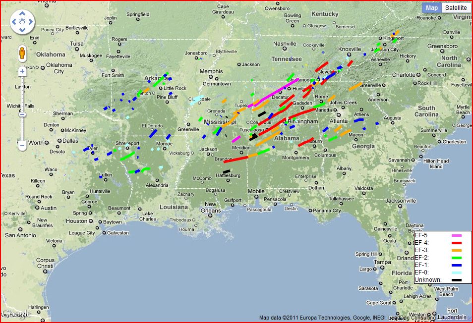


 Images (click to enlarge): Preliminary April 25-28 tornado tracks as of May 6, pavement and turf gouging from the Neshoba County, Mississippi EF-5 tornado, from NWS
As the painstaking work of surveying the damage from the record tornado outbreak continues, the National Weather Service (NWS) announced this afternoon that a second Mississippi tornado on April 27 has been upgraded to EF-5 intensity. The new evaluation of the Neshoba/Noxubee County storm was based on analysis of extraordinary ground damage consistent with EF-5 strength winds: Large sections of sod and asphalt paving were literally ripped out of the ground.
This was the first EF-5 tornado in the area covered by the Jackson, Mississippi NWS office in over 40 years, since Feb. 21, 1971. Along with the previously identified Smithville EF-5, this was the first time since tornado records began that 2 EF-5 tornadoes have been observed in Mississippi on the same day. This also brings to 3 the number of EF-5 storms in the record outbreak of April 25-28, with about two-thirds of the storms surveyed so far.
The total number of confirmed tornadoes in the Jackson region now stands at 31, with
4 EF-0The NWS reports:
10 EF-1
11 EF-2
4 EF-3
1 EF-4
1 EF-5
IN TWO LOCATIONS...THE TORNADO ACTUALLY GOUGED OUT LARGE SECTIONS OF
THE GROUND. IN ONE SPOT IN NORTHEAST NESHOBA COUNTY...THE GROUND WAS
DUG OUT TO A DEPTH OF AROUND 2 FEET OVER AN AREA APPROXIMATELY 25-50
YARDS WIDE AND A COUPLE OF HUNDRED YARDS LONG. SIMILAR GOUGES...
ALTHOUGH NOT AS LONG OR DEEP...WERE ALSO OBSERVED IN EXTREME
NORTHWEST KEMPER COUNTY. WHILE THE EXACT MECHANISM THAT CAUSED THIS
DAMAGE IS UNCLEAR...INDICATIONS ARE THAT THIS TYPE OF GROUND DAMAGE
IS TYPICALLY ASSOCIATED WITH THE EXTREME WIND SPEEDS ASSOCIATED WITH
EF-5 TORNADOES.

IN THE AREA OF NORTHWEST KEMPER COUNTY WHERE THE GROUND GOUGING WAS
OBSERVED...THERE WAS ALSO AN AREA WHERE PAVEMENT WAS REMOVED FROM
THE GROUND. WHILE THIS TYPE OF DAMAGE CAN BE CAUSED BY TORNADOES OF
LESS THAN EF-5 INTENSITY...THE FACT THAT PIECES OF ASPHALT WERE
FOUND AT A SIGNIFICANT DISTANCE AWAY...BOTH UPWIND AND DOWNWIND OF
THE ROAD...ARGUES FOR EXTREME WIND SPEEDS. SIMILAR TYPE DAMAGE WAS
ALSO OBSERVED IN SOUTHWEST NOXUBEE COUNTY.

FINALLY...EXTREME VEHICLE DAMAGE OF THE TYPE NORMALLY ASSOCIATED
WITH EF-5 TORNADOES WAS OBSERVED.  THIS INCLUDED NEW VEHICLES BEING
MOVED MORE THAN 100 YARDS FROM WHERE THEY STARTED...AND BEING LEFT
IN A NEARLY UNRECOGNIZABLE STATE.
Subscribe to:
Posts (Atom)
Seasonal Outlook
Latest seasonal forecast: Click here.

Latest 3-month temperature outlook from Climate Prediction Center/NWS/NOAA.
Latest 3-month temperature outlook from Climate Prediction Center/NWS/NOAA.


 Posts
Posts


