Friday, December 21, 2012

Chicago Ends Record Snowless Streak;
Other Streaks Continue

Image (click to enlarge): Chicago regional snowfall on December 20, 2012, from National Weather Service

The 0.2" of snow on Thursday (December 20) at Chicago ended the record longest streak without measurable snow. It was also the latest occurrence of a first measurable snow. Other streaks are continuing, including:

- 300th day without a high temperature below freezing (tied for 2nd longest)
- Latest first day of the season with high temperature below freezing (tied for 5th)
- 301st day without an inch or more of snow (8th longest)
- 299th day without an inch of snow on the ground (3rd longest)
- 344th day of the year without a high at or above freezing (tied for 8th)

The average temperature for 2012 to date is also well on the way to being the warmest on record at Chicago.

Here is the complete report from the National Weather Service:
THURSDAY`S STORM IN CHICAGO MANAGED TO MUSTER UP A COUPLE TENTHS
OF AN INCH OF ACCUMULATION WHICH OFFICIALLY ENDED CHICAGO`S SNOW
DROUGHT AND ESTABLISHED NEW RECORDS FOR LATEST FIRST MEASURABLE
SNOWFALL AND LONGEST STRETCH OF NO MEASURABLE SNOWFALL EVER IN
CHICAGO. HOWEVER...THURSDAY STORM HAS LEFT INTACT SOME OTHER
NOTABLE STREAKS FOR CHICAGO.

TEMPERATURES AT MIDNIGHT WERE STILL ABOVE FREEZING...SO THE STREAK
OF DAYS WITHOUT A SUB-FREEZING HIGH TEMPERATURE CONTINUES IN
CHICAGO. TODAY`S HIGH TEMPERATURE ABOVE FREEZING MAKES IT THE 300TH
CONSECUTIVE DAY WITHOUT A HIGH TEMPERATURE BELOW FREEZING...TYING
2004 FOR THE 2ND LONGEST STREAK. THE FORECAST SUGGESTS THIS STREAK
WILL CONTINUE THIS WEEKEND WHICH WOULD MAKE THIS YEAR THE LONGEST
STREAK WITHOUT A SUB-FREEZING HIGH TEMPERATURE SINCE 1878 WHEN
CHICAGO`S OFFICIAL OBSERVATION STATION WAS AT THE CHICAGO OPERA
HOUSE ON THE CORNER OF CLARK AND WASHINGTON IN THE LOOP. HERE ARE
THE TOP 5 LONGEST STREAKS OF CONSECUTIVE DAYS WITHOUT A HIGH
TEMPERATURE ABOVE FREEZING...

  # DAYS     END DATE
1)  308     12/15/1878
2)  300+    12/21/2012+
    300     12/12/2004
4)  290     12/09/2011
5)  289     12/24/1918

NOW THAT TODAYS HIGH TEMPERATURE IN CHICAGO WILL OFFICIALLY BE AT
LEAST 33F (THE READING AT MIDNIGHT)...THIS YEAR IN CHICAGO IS NOW
GUARANTEED TO MOVE INTO AT LEAST A TIE FOR 5TH PLACE FOR LATEST
FIRST DAY OF THE SEASON WITH A HIGH TEMPERATURE BELOW FREEZING.
HERE ARE THE TOP 5 LATEST DATES FOR FIRST DAY WITH HIGHS BELOW
FREEZING...

1) JAN 1 1924
2) DEC 28 1971
3) DEC 25 1918
4) DEC 24 2011
5) DEC 22 1998
   ??? ?? 2012

THE LAST TIME CHICAGO HAS HAD A CALENDAR DAY SNOWFALL OF ONE INCH
WAS BACK ON FEBRUARY 24TH...SO TODAY WILL BE THE 301ST CONSECUTIVE
DAY WITHOUT A 1 INCH SNOWFALL MAKING IT THE 8TH LONGEST STREAK
EVER IN CHICAGO. WITH SEVERAL MORE DAYS OF NO SNOW EXPECTED...THIS
YEAR IS BOUND TO MOVE UP IN THE RANKINGS. HERE ARE THE TOP TEN
LONGEST STREAKS WITHOUT A 1 INCH CALENDAR SNOWFALL...

  # DAYS     END DATE
1)  319     01/06/1940
2)  315     12/07/1958
3)  307     12/03/1921
4)  305     01/15/2002
5)  303     01/07/1944
6)  302     12/09/1988
    302     11/16/1927
8)  301+    12/21/2012+
9)  299     12/29/1990
10) 298     12/23/1918

CALENDAR SNOWFALL MAY BE SOMEWHAT DECEPTIVE SINCE THERE WERE LIKELY
EVENTS IN SOME OF THOSE YEARS WHERE A SNOWFALL MAY HAVE CROSSED
CALENDAR DAYS WITH A STORM TOTAL GREATER THAN 1 INCH...BUT EACH
CALENDAR DAY LESS THAN AN INCH RESPECTIVELY. TO REALLY PUT OUR SNOW
DROUGHT IN PERSPECTIVE...IT HAS BEEN 299 DAYS NOW SINCE CHICAGO HAS
OFFICIALLY HAD AN INCH OF SNOW ON THE GROUND. THIS IS THE 3RD
LONGEST STREAK OF CONSECUTIVE DAYS WITHOUT AN INCH OF SNOW ON THE
GROUND. HERE ARE THE TOP 5 LONGEST STREAKS...

  # DAYS     END DATE
1)  313     01/06/1940
2)  302     01/07/1944
3)  299+    12/21/2012+
4)  296     12/12/1988
    296     12/14/1946

ANOTHER INTERESTING STATISTIC IS THAT CHICAGO HAS HAD 344 DAYS WITH
HIGHS AT OR ABOVE FREEZING SO FAR THIS YEAR...WHICH ALREADY PLACES
US TIED FOR THE 8TH MOST NUMBER OF DAYS WITH HIGHS AT OR ABOVE
FREEZING IN A YEAR. WITH 10 MORE DAYS TO GO THIS YEAR AND MANY OF
THEM LIKELY ABOVE FREEZING 2012 IS LIKELY TO MOVE UP IN THE RANKING
HERE AS WELL. HERE ARE THE TOP 10 MOST NUMBER OF DAYS ABOVE FREEZING
IN A YEAR...

  # DAYS    YEAR
1)  355     1931
2)  353     2006
3)  348     1990
4)  346     1987
5)  345     1878
    345     1992
    345     1998
8)  344     1954
9)  343+    2012 (THROUGH AND INCLUDING 12/21/2012)
10) 342     1882
    342     1911
    342     1921

FINALLY...THE AVERAGE TEMPERATURE IN CHICAGO SO FAR THIS YEAR HAS
BEEN 55.4 DEGREES WHICH PLACES 2012 WITHIN STRIKING DISTANCE OF
BREAKING THE RECORD FOR THE WARMEST YEAR EVER IN CHICAGO. THE
PREVIOUS RECORD WARMEST YEAR WAS 1921 WHEN THE AVERAGE TEMPERATURE
WAS 54.5F. IN ORDER TO HAVE THIS YEAR AVERAGE 54.6F AND BREAK THE
RECORD THE LAST 11 DAYS OF THE YEAR NEED TO HAVE AN AVERAGE
TEMPERATURE OF APPROXIMATELY 28.8F. IN ORDER FOR 2012 TO BE TIED FOR
THE WARMEST YEAR ON RECORD IN CHICAGO THE REMAINING 11 DAYS OF THE
YEAR WOULD NEED TO HAVE AN AVERAGE TEMPERATURE OF APPROXIMATELY
25.5F. 

Tuesday, December 18, 2012

New South Carolina All-Time State High Temperature Record Confirmed


Images (click to enlarge): South Carolina high temperatures, June 29, 2012, from National Weather Service; Location of South Carolina all-time record high temperature, from South Carolina State Climatologist

The South Carolina State Climatologist announced today that the temperature of 113°F observed at Columbia on June 29, 2012 has been officially confirmed as a new all-time record high temperature for the state.
The temperature observation of 113 F recorded that day at the Columbia University of South Carolina National Weather Service (NWS) Cooperative site has been approved as the new state of South Carolina record maximum temperature. This value breaks the long-standing record of 111 F first set on September 4, 1925, at Blackville, at Calhoun Falls on September 8, 1925, and tied at Camden on June 27, 1954. South Carolina’s first state temperature record was recognized in 1887, 125 years ago.
Here are some other South Carolina high temperature reports for June 29, from the National Weather Service:
...ASOS STATIONS...

AUGUSTA BUSH APT  GA              106
AUGUSTA DANIEL APT GA             107
ORANGEBURG AIRPORT SC             101
COLUMBIA METRO APT SC             109
COLUMBIA OWENS APT SC             110

...COOP STATIONS...

BAMBERG SC                        106
BARNWELL SC                       105
BATESBURG SC                      106
BISHOPVILLE SC                    106
CEDAR CREEK SC                    107
CHERAW WATER PLANT SC             104
CHESTERFIELD SC                   107
JOHNSTON SC                       113
LITTLE MOUNTAIN SC                107 
LONGTOWN SC                       102
LUGOFF SC                         105 
MANNING SC                        100
MCCORMICK SC                      108
NEWBERRY SC                       104
PELION SC                         104
SALUDA FILTRATION PLANT SC        109
SANDHILL EXP STATION SC           109
USC, COLUMBIA SC                  113  
WIER TOWER, FORT JACKSON SC       108             

...OTHER STATIONS...

CAROLINA SANDHILL SC              106
USFS NEAR JACKSON NUMBER 1 SC     105
JACKSON SC                        105 

Monday, December 17, 2012

Global Temperature Update: 5th Warmest November, 2nd Warmest Fall, 8th Warmest Year to Date

The National Climatic Data Center preliminary analysis for November 2012 shows that it was the 5th warmest November globally since records began in 1880. For meteorological autumn (September-November), it was the 2nd warmest, and for 2012 to date, it was the 8th warmest. Monthly global temperatures have been among their respective top 5 months for each of the 8 months since April. All of the 10 warmest Novembers have occurred in the last 12 years.

From the NCDC:
The average combined global land and ocean surface temperature for November 2012 was 0.67°C (1.21°F) above the 20th century average of 12.9°C (60.4°F). This is the fifth warmest November since records began in 1880. Including this November, the 10 warmest Novembers have occurred in the past 12 years.

The average combined global land and ocean surface temperature for September–November 2012 was 0.67°C (1.21°F) above the 20th century average of 14.0°C (57.1°F), marking the second warmest September–November on record, behind 2005.

The combined global land and ocean average surface temperature for January–November 2012 was the eighth warmest such period on record, at 0.59°C (1.06°F) above the 20th century average.
Images (click to enlarge): Global surface temperature anomalies (°C) for November 2012 and global surface temperature anomalies for November from 1880 through 2012, from NCDC


Wednesday, December 12, 2012

Spectacularly Warm Start to December in U.S.;
Above-Average Temperatures From Coast to Coast

As noted last week, December got an exceptionally warm start in the contiguous 48 states of the U.S., and that trend has continued even more strongly through the first third of the month. Except for 2 weeks in October, nationwide temperatures have been warmer than average every week in 2012 and for 50 of the last 52 weeks.

For December 1-10, temperatures have averaged above normal everywhere from coast to coast. In the calender week ending December 8, of the 215 first-order National Weather Service (NWS) stations reported weekly by the Climate Prediction Center, 1 was missing (Glasgow, Montana), none were equal to or colder than average, only 1 was 1° above average (Key West, Florida), 2 were 2° above, and all the rest were at least 3° above. Over half of the reporting locations were 10° or more warmer than average, and 15 of them across 10 states (AL, AR, IA, IL, IN, KY, MO, MS, SD, TN) had departures of 15° or more for the week.

Even in a year with very warm extremes in January, March, and July, this was some serious heat. For the country overall, the average for all 214 NWS stations was slightly over 10.0° above normal, and the National Climatic Data Center (NCDC) geographically adjusted average was 8.9° above average.

Temperatures have not only been consistently warm over a wide area, but many individual locations have set records. For the first 10 days of December, new daily record high temperatures have outnumbered record lows by a ratio of 92 to 1. For the 48 contiguous states, the ratio was an incredible 132 to 1, since 3 out of the 10 low records were in Alaska and Hawaii. During the entire week of December 2-8, not a single low temperature record was tied or broken in any of the 50 states, according to NCDC reports. With 3 weeks remaining in the year, the cumulative ratio of heat records to cold records for 2012 has reached 6.0 to 1, more than double the ratio in 2011.

Images (click to enlarge):
- Weekly average U.S. temperature departures from normal for 2012, through December 8 (20121208); CapitalClimate chart from NOAA/NCDC data
- Weekly average NWS station temperature departures from normal, week ending December 8, 2012; stations listed alphabetically by state and 3-character station identifier; CapitalClimate chart from NWS data
- December 1-10, 2012 U.S. temperature departure from average, from High Plains Regional Climate Center
- Monthly ratio of daily high temperature to low temperature records set in the U.S. for November 2011 through December 2012 to date, seasonal ratios for summer 2011 through fall 2012, and annual ratios for 2012 and 2011.
CapitalClimate chart from NOAA/NCDC data, background image © Kevin Ambrose. Includes historical daily observations archived in NCDC's Cooperative Summary of the Day data set and preliminary reports from Cooperative Observers and First Order National Weather Service stations. All stations have a Period of Record of at least 30 years.

Monday, December 10, 2012

Counting Down to Washington's Record Warmest Year: "It Hasn't Warmed Since 2012!"

Record Hot Year Countdown Scorecard

Date  High Low 2012-YTD 1991-YTD Departure to Miss 
12-10 63   49   62.7      61.5    -18.1    
12-11 62   41   62.6      61.4    -19.5 
12-12 47   39   62.6      61.4    -20.7  
12-13 50   35   62.5      61.4    -22.1 
12-14 52   30   62.5      61.4    -23.4 
12-15 54   37   62.4      61.3    -25.2
12-16 52   46   62.4      61.2    -27.6
12-17 55   48   62.4      61.1    -30.5
12-18 62   43   62.3      61.1
12-19 54   36   62.3      61.0
12-20 53   41   62.2      60.9    -41.0  
12-21 59   39   62.2      60.8
12-22 45   35   62.1      60.8
12-23 47   29   62.1      60.7
12-24 41   31   62.0      60.7
12-25 51   34   61.9      60.6 
12-26 45   33   61.9      60.5
12-27 43   37   61.8      60.5
12-28 45   36   61.8      60.4
12-29 42   34   61.7      60.4
12-30 42   32   61.6      60.3
12-31 41   29   61.6      60.2 
(Departure to Miss indicates how much the average temperature must be below normal for the rest of the year in order to avoid setting a new record for warmest year.)

January 2 Update: Thanks to a quirk in calculation methodology, the National Weather Service is rounding down the final average to 61.5°. It was also the record warmest year at Washington Dulles and the 3rd warmest at Baltimore. From the NWS report:
2012 WAS THE WARMEST YEAR ON RECORD FOR WASHINGTON DC WITH AN ANNUAL AVERAGE TEMPERATURE OF 61.5 DEGREES. THE PREVIOUS WARMEST ANNUAL AVERAGE TEMPERATURE ON RECORD WAS 60.2 DEGREES IN 1991. THE AVERAGE TEMPERATURE FOR 2012 WAS 3.3 DEGREES ABOVE THE 1981-2010 NORMAL AND WOULD BE COMPARABLE TO THE NORMAL ANNUAL TEMPERATURE OF ATLANTA...OKLAHOMA CITY AND SAN JOSE...JUST TO NAME A FEW LOCATIONS.

DULLES ALSO EXPERIENCED THEIR WARMEST YEAR ON RECORD WITH AN ANNUAL AVERAGE TEMPERATURE OF 57.9 DEGREES IN 2012. THE PREVIOUS WARMEST YEAR ON RECORD WAS 1998...WHEN THE ANNUAL AVERAGE TEMPERATURE WAS 57.1 DEGREES. THE 2012 AVERAGE TEMPERATURE WAS 2.6 DEGREES ABOVE THE 1981-2010 NORMAL.

2012 WAS THE THIRD WARMEST YEAR ON RECORD FOR BALTIMORE WITH AN ANNUAL AVERAGE TEMPERATURE OF 58.6 DEGREES. ONLY 1931 AND 1949 WERE WARMER WHEN THE ANNUAL AVERAGE TEMPERATURES BOTH YEARS WERE 59.2 DEGREES. THE 2012 AVERAGE TEMPERATURE WAS 3.5 DEGREES ABOVE THE 1981-2010 NORMAL.

December 31 Update: The 42/32 temperatures yesterday and 41/29 today give a final unofficial yearly average of 61.6°, so the record is broken by the higher amount of 1.4°. (Chart updated)

December 29 Update: Today's high of 42° exceeded expectations by 4°, so the gap to a final yearly average of 61.6° has narrowed to less than 0.004°. A miss of Monday's forecast low of 26° could be the clincher.

December 28 Update: Today's +4° temperature departure means the remaining 3 days need to average -0.5° or warmer to clinch a 1.4° excess over the old annual record. The forecast is for a deficit of 2.1°, however.

December 27 Update: Thanks to continued above-average temperatures, a departure of just 1° in the next 4 days would be enough to raise the final yearly average to 1.4° above the old record.

December 25 Update: Yesterday was just the second day this month with cooler than average temperatures (2° below). Today's high outpaced expectations, however, as so many recent days have done. The year-to-date average is outpacing the previous record by 1.3° at 61.9°. With less than a week now remaining, it is now highly likely that the final yearly average will break the record by that amount. The forecast temperatures for the next 6 days average exactly equal to normal, and the average would have to be at least 5° colder in order to avoid a final average 1.3° above the old record. On the other hand, a departure of just +1.2° for the final 6 days would raise the yearly average by another 0.1°.

December 17 Update: Today's low of 48° through 5 pm is 2° above the normal high. At this point, even if temperatures set new record lows and record cold highs for every day in the next 2 weeks, it will still be a record warm year.

December 15 Update: While it's technically not impossible, Washington would now have to set a new record low temperature every day for the next 16 days in order to avoid setting a new record high annual temperature. (See scorecard above.)

December 13 Update: The temperature departure from normal required to avoid setting a new record is now over 22° for every day for the rest of the year. Since that is clearly not happening soon, we are verging on the realm of physical impossibility to avoid a record. The average of all record low temperatures for every day from the 14th through the 31st is -25.5° relative to normal.

December 12 Update: Yesterday's high/low temperatures went virtually midnight to midnight; the final values of 62°/41° averaged out 11° above normal. Today was considerably colder, but the 47°/39° range was still 3° on the warm side. Using the forecast temperatures for the next 7 days and climatology for the remainder of the month yields a projected yearly average of 61.4°. It would have to average almost 21° below normal for the rest of the month in order to avoid breaking the previous record.

Original post:
With just 3 weeks remaining before New Year's Eve, it's becoming increasingly evident that the climate denialists will have to find a replacement for the tired old talking point, "It hasn't warmed since 1998." As the November climate summary showed, 2012 is well on its way to being the warmest on record in the U.S. contiguous 48 states. That will most likely be true in many individual locations as well, particularly in Washington DC.

While well below the record for December 10, today's high of 63° was 15° above average, and the low so far of 49° is a degree above the normal high. This puts the average for the month over 50°, more than 7° above normal to date. If this were to continue through the end of the month (extremely unlikely), it would be the warmest December on record by over 4°.

The year-to-date average temperature of 62.7° is 1.2° above the pace of the previous record warmest year of 1991. If the remaining 3 weeks average just normal (high/low range of 48/34 currently, declining to 44/29 by the 31st), the final 2012 average (marked "Climo" on the charts) will still be 1.1° above the old record. This is a huge amount for a yearly average, as indicated by the top-10 chart, which shows only a 0.9° difference between the current record and the 10th place year of 2002.

It will certainly be colder between now and the end of the month, but how much colder would it have to be to avoid breaking the record? Assuming today's low remains unchanged through midnight, the remaining 21 days of December would have to average an eye-popping -18.1° relative to normal just to tie with 1991. That means an average high for 3 weeks below 30° and an average low below 16°. While such a frigid blast is not physically impossible, it would take an incredibly intense and fanatical belief in the Ice Age Fairy to think that it will happen.

Stay tuned; we'll keep you posted as this historic event unfolds.

Note: While not unexpected, these results were so extreme the the Climate Capitalist suspected that the data monkeys down at Momma Nature's Weather Grill had gotten into the eggnog a bit early. A cross-check of the daily year-to-date values with the monthly averages and a comparison of the projection with a hand calculator confirmed the data, however.


Sunday, December 9, 2012

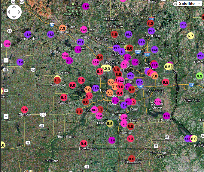
Record Daily Snowfall at Minneapolis


Images (click to enlarge): Snowfall amounts in Minnesota and the Minneapolis region, December 8-9, from National Weather Service

December 14 Update: The average temperature at Minneapolis for the first 2 weeks of December is 7.2° warmer than normal. Only 2 days so far have been colder than average. See here for more on this developing Ice Age.

December 10, 10 AM Update:
The final total for Minneapolis was 10.5".

St. Cloud also set records for both snowfall and precipitation:
A RECORD SNOWFALL OF 11 INCH(ES) WAS SET AT ST CLOUD MN YESTERDAY.   
THIS BREAKS THE OLD RECORD OF 5.1 SET IN 1961.  

A RECORD RAINFALL OF 0.87 INCH(ES) WAS SET AT ST CLOUD MN YESTERDAY.   
THIS BREAKS THE OLD RECORD OF 0.36 SET IN 1899. 
Elsewhere in Minnesota and South Dakota:
A TOTAL OF 0.35 INCHES OF LIQUID PRECIPITATION WAS RECORDED AT THE   
ROCHESTER INTERNATIONAL AIRPORT YESTERDAY...DECEMBER 9TH. THIS   
BREAKS THE PREVIOUS DAILY PRECIPITATION RECORD OF 0.31 INCHES THAT   
WAS SET ON THIS DATE IN 2009.  

SNOWFALL IN HURON SOUTH DAKOTA YESTERDAY...DECEMBER 8TH...TOTALED   
6.5 INCHES. THIS BREAKS THE OLD RECORD DAILY SNOWFALL OF 3.6 INCHES   
SET BACK IN 2008.  
  
THE WATER EQUIVALENT OF 0.52 INCHES ALSO BREAKS THE RECORD DAILY   
RAINFALL FOR DECEMBER 8TH. THE PREVIOUS RECORD WAS 0.38 INCHES...   
ALSO SET IN 2008.  
Original post:
The snowfall at Minneapolis today has set a record for December 9. From the National Weather Service:
A RECORD SNOWFALL OF 10.2 INCH(ES) WAS SET AT TWIN CITIES MN TODAY.
THIS BREAKS THE OLD RECORD OF 7.4 SET IN 1961. 
The all-time record December snowstorm at Minneapolis was 17.1" on Dec. 10-11 2010. That was the 5th largest snowstorm for any month:
1. OCT 31-NOV 3 1991 28.4  
2. NOV 29-DEC 1 1985 21.1  
3. JAN 22-23 1982 .. 20.0
4. JAN 20-21 1982 .. 17.4 
5. DEC 10-11 2010 .. 17.1  
6. NOV 11-12 1940 .. 16.8 
So far this month, the Minneapolis temperature has been 11.2° above average.

Friday, December 7, 2012

Midwest Mildness Smashes Snowless Streaks;
Records Broken in Nebraska

December 10 Update: The streak continues at Milwaukee, where no precipitation is forecast before Saturday. It also continues at Chicago, Omaha, Lincoln.

December 9 Update:
The Omaha snowless streak has continued through today, bringing the new record to 289 days, 5 beyond the old record.

The Lincoln streak has also extended through today, reaching 300 days.

The Norfolk NE streak ended on December 7 (Friday) with 0.5", missing the record.

Milwaukee has had no snow so far today, which will break the record if it extends to midnight. With the temperature of 37° and light drizzle at 7 pm CST, that seems likely.

The Des Moines record streak ended today at 279 days with 1.4" of snow.

On December 7, the WGN Chicago Weather Center blog reported:
As of Friday evening the steak of days without measurable (0.1 inch) snow at Chicago's official O'Hare International Airport observation site had reached 278 - the last measurable snow occurring back on March 4th. Chicago's record longest consecutive day period without measurable snow (since 1871) was 280 days set back in 1994.
Chicago has received no measurable snow so far today, so it's likely that the record will at least be tied.

Original Post:
The record warmest year to date in U.S. climate history and the ongoing Midwest drought have combined to produce record longest snowless streaks at several locations. The image above from the Rutgers Global Snow Lab (click to enlarge) shows virtually no snow cover in North America south of the Canadian border with the U.S. as of yesterday, December 6.

From the National Weather Service:
Omaha last recorded measurable snowfall on February 24, 2012, with 0.2 inches. The streak of 284 days since that date is tied for the longest snow-free streak on record at Omaha as of December 4, and the streak will be extended at least for the next couple of days. The previous record of 284 days ended on December 30, 2006, which was the latest date of the first measurable snow on record in Omaha. Snowfall records in Omaha go back to the winter of 1884-85, with two missing years (1996-97 and 1997-98).

Lincoln last recorded measurable snowfall on February 13, 2012, with 1.1 inches. The streak of 295 days since that date is tied for the longest snow-free streak on record at Lincoln as of December 4, and the streak will be extended at least for the next couple of days. The previous record of 295 days ended on November 27, 2004. Snowfall records in Lincoln go back to the winter of 1948-49, with one missing year (1996-97).

Norfolk last recorded measurable snowfall on February 24, 2012, with 1.0 inches. The streak of 284 days since that date is the third longest snow-free streak on record at Norfolk as of December 4, and the streak will be extended at least for the next couple of days. The record of 298 days ended on January 13, 2007, which was the latest date of the first measurable snow on record in Norfolk. Partial snowfall records in Norfolk go back to the winter of 1893-94, with complete records beginning in 1946-47.

The long streak without measurable snowfall is due to a combination of ongoing drought conditions and record warmth. 2012 remains the warmest year to date on record at Omaha and Norfolk and the 3rd warmest on record in Lincoln. Also, 2012 is the 2nd driest year to date in Norfolk, the 7th driest year to date in Lincoln, and the 20th driest year to date in Omaha.

Total snowfall for the calendar year 2012 to date in Omaha is 12.8 inches, which is the 5th lowest on record for a calendar year (of all the complete years). For Lincoln, the total snowfall for the calendar year 2012 to date is 13.9 inches, which is also the 5th lowest on record for a calendar year. At Norfolk, the total snowfall for the calendar year 2012 to date is 7.2 inches, which is the lowest on record for a calendar year, in years with complete records.
In Milwaukee, Wisconsin, today will tie the record for second longest streak. If it lasts through Sunday, it will break the record:
As of Thursday, December 6th, Milwaukee has gone 277 days since the last day with measurable snow, which is the 3rd longest streak on record. The last time Milwaukee had measurable snow was on March 4, 2012, when 0.9 inches was measured.

Milwaukee will be able to add more days to the streak, since there are only small chances of snow this weekend, with better chances for rain, given the mild temperatures that are forecast.

If Milwaukee makes it through today, with no measurable snow, that will tie for the second longest streak on record (278 days, set in 1908).

If Milwaukee makes it through Saturday, December 8th, with no measurable snow, that will tie for the longest streak on record (279 days, set in 1999).

Finally, if Milwaukee makes it through Sunday, December 9th, with no measurable snow, that will establish the longest streak on record.

The latest date for the first measurable snow in a winter season in the climate record for Milwaukee is December 26, 1888, when 0.1 inches of snow fell. The latest first one inch or greater snowfall in a winter season was on January 20, 1889, when 3.5 inches of snow fell. Thus, both these records occurred in the winter of 1888-1889.
On Tuesday, December 4, the NWS at Des Moines, Iowa, tweeted: With no snow though today, the record will be broken.

Seasonal Outlook

Latest seasonal forecast: Click here.


Latest 3-month temperature outlook from Climate Prediction Center/NWS/NOAA.