
Thursday, May 12, 2011
Tuesday, May 10, 2011
Record Heat in Kansas, Missouri, Oklahoma; Earliest 100° at Wichita
Update: Century-Old Records Also Broken By Wide Margin in Nebraska, Iowa
See Record Heat for the latest updates.
May 11, 2 PM Update: The preliminary report from the National Climatic Data Center shows 186 high temperature records set on May 10, vs. 8 new lows (click image to enlarge):

May 10, Midnight Update: Some more records from Iowa, Nebraska, South Dakota, Kansas, Texas, and Louisiana:
May 10, 9 PM Update: The NWS reports the following preliminary records in Iowa:
The Iowa weather map as of 5 pm CDT shows 90° or higher temperatures throughout nearly all of the state.

May 10, 5 PM Update: New records at 4 pm CDT (previous records in parentheses):
May 10, 4 PM Update:
The focus of extreme heat has shifted this afternoon to Iowa, where records have already fallen:

The NWS reports that records were also set yesterday (May 9) in Nebraska:
Original post: (Corrected date in first sentence to May 9.)
Late spring heat soared to summer levels across Kansas on May 9. The high of 100° at Wichita not only smashed the 116-year-old record for the date by 5°, but it was the earliest 100° ever recorded there. The top 5 earliest:
May 11, 2 PM Update: The preliminary report from the National Climatic Data Center shows 186 high temperature records set on May 10, vs. 8 new lows (click image to enlarge):

May 10, Midnight Update: Some more records from Iowa, Nebraska, South Dakota, Kansas, Texas, and Louisiana:
THE FINAL HIGH TEMPERATURE OF 96 DEGREES AT 532 PM CDT IN SIOUX CITY
BROKE THE RECORD OF 90 DEGREES...SET IN 1987.

THE FINAL HIGH TEMPERATURE OF 95 DEGREES AT 408 PM CDT IN SPENCER
BROKE THE RECORD OF 93 DEGREES...SET IN 1987.

THE FINAL HIGH TEMPERATURE OF 96 DEGREES AT 455 PM CDT IN STORM LAKE
BROKE THE RECORD OF 87...LAST SET 1987...BUT ALSO OCCURRING IN 1963
AND 1911.

THE HIGH TEMPERATURE UP TO 342 PM CDT IN SIOUX CENTER WAS 94
DEGREES. THIS BROKE THE RECORD OF 92...SET IN 1987.

A RECORD HIGH TEMPERATURE OF 92 DEGREES WAS SET AT BURLINGTON TODAY.
THIS BREAKS THE OLD RECORD OF 88 SET IN 1956.

A RECORD HIGH TEMPERATURE OF 91 DEGREES WAS SET AT NORFOLK, NEBRASKA
AT 6:03 PM CDT TODAY. THIS BREAKS THE OLD RECORD OF 89 SET IN 1915.

A RECORD HIGH TEMPERATURE OF 95 DEGREES WAS SET AT LINCOLN, NEBRASKA
AT 5:15 PM CDT TODAY. THIS BREAKS THE OLD RECORD OF 93 SET IN 1962.

A RECORD HIGH TEMPERATURE OF 97 DEGREES WAS SET AT OMAHA EPPLEY,
NEBRASKA AT 5:52 PM CDT TODAY. THIS BREAKS THE OLD RECORD OF 93 SET
IN 1962.

THE HIGH TEMPERATURE UP TO 3 PM CDT IN VERMILLION SOUTH DAKOTA WAS
94 DEGREES. THIS BROKE THE PREVIOUS RECORD OF 92 DEGREES...SET IN
1987.

A RECORD HIGH TEMPERATURE OF 92 DEGREES WAS SET AT TOPEKA KS TODAY.
THIS BREAKS THE OLD RECORD OF 90 SET IN 1911.

...DAILY RECORD HIGH TEMPERATURE RECORDS TIED FOR THE DATE OF MAY
10TH...

LOCATION       OLD RECORD      NEW RECORD        YEARS OF DATA
-----------------------------------------------------------------
LUFKIN TX      93 IN 2008      93 IN 2011      RECORDS SINCE 1906

...DAILY RECORD HIGH TEMPERATURE RECORDS BROKEN OR TIED FOR THE DATE
OF MAY 9TH...

LOCATION       OLD RECORD      NEW RECORD        YEARS OF DATA
-----------------------------------------------------------------
SHREVEPORT LA  93 IN 1887      93 IN 2011      RECORDS SINCE 1874
LUFKIN TX      93 IN 2008      95 IN 2011      RECORDS SINCE 1906
TYLER TX       95 IN 1941      95 IN 2011      RECORDS SINCE 1896
May 10, 9 PM Update: The NWS reports the following preliminary records in Iowa:
Location Today's High (F) Previous Record (F) Normal High (F)May 10, 6 PM Update: The NWS is currently (5 pm local) reporting 95° at Des Moines, so the record has been exceeded by at least 1 more degree. Also, Lamoni has reached at least 91° and Waterloo 93°.
Des Moines: 95 degrees 90 degrees in 1911 70 degrees
Waterloo: 93 degrees 91 degrees in 1987 70 degrees
Ottumwa: 92 degrees 89 degrees in 1934 70 degrees
Mason City: 94 degrees 89 degrees in 1987 68 degrees
Lamoni: 91 degrees 86 degrees in 1911 70 degrees
The Iowa weather map as of 5 pm CDT shows 90° or higher temperatures throughout nearly all of the state.

May 10, 5 PM Update: New records at 4 pm CDT (previous records in parentheses):
Waterloo IA 92° (see below)According to The Weather Channel, this is the first 90°+ temperature of the year at Chicago, vs. an average date of June 6.
Mason City IA 93° (89°, 1987)
Burlington IA 91° (88°, 1956)
Moline IL 93° (89°, 1911)
Chicago IL 90° (89°, 1896)
St. Joseph MO 93° (91°, 2005, 1962)
Topeka KS 92° (90°, 1911)
Imperial NE 93° (92°, 1928)
May 10, 4 PM Update:
The focus of extreme heat has shifted this afternoon to Iowa, where records have already fallen:
- The 3 pm CDT temperature of 94° at Des Moines exceeds the forecast and breaks the old record for the date of 90° in 1911 by 4°.
- The 91° at Waterloo also exceeds the forecast and the old record of 90° in 1911.
- The 91° at Ottumwa exceeds the old record of 89° in 1934.
- The 90° at Lamoni exceeds the old record of 86° in 1911.

The NWS reports that records were also set yesterday (May 9) in Nebraska:
On Monday afternoon, May 9th, 2011, automated ASOS equipment at Central Nebraska Regional Airport in Grand Island recorded a new maximum temperature record of 98 degrees. This broke the old May 9th record of 95 degrees set back in 1934.
Temperature records at Grand Island date back to 1896.
On Monday afternoon, May 9th, 2011, the official NWS Cooperative Observer at Kearney Regional Airport reported a high temperature of 97 degrees. This breaks the previous record of 93 degrees, set EXACTLY 100 years ago today in 1911.
Temperature records at Kearney date back to 1902.
On Monday afternoon, May 9th, 2011, automated ASOS equipment at Hastings Municipal Airport in Hastings tied a new maximum temperature record of 95 degrees. This [tied] the old May 9th record of 95 degrees set back in 1934.
Temperature records at Hastings date back to 1907.
99 degrees at Norfolk broke the old record of 94 degrees set in 1928. 96 degrees at Omaha tied the record of 96 degrees set in 1895. Lincoln at 96 degrees came up just short of their 97 degree record set in 1895.
Original post: (Corrected date in first sentence to May 9.)
Late spring heat soared to summer levels across Kansas on May 9. The high of 100° at Wichita not only smashed the 116-year-old record for the date by 5°, but it was the earliest 100° ever recorded there. The top 5 earliest:
1. May 9th 2011The National Weather Service also reports daily records at Russell and Salina:
2. May 10th 1967
3. May 23rd 1996
4. May 25th 1962
5. May 29th 1913
AT RUSSELL THE MERCURY ROSE TO 100 DEGREES. THIS BROKE THEIR OLDOther record heat:
RECORD OF 97 SET IN 1956. SALINA...THEIR HIGH TEMPERATURE WAS 101
DEGREES WHICH WAS 5 DEGREES ABOVE THEIR OLD RECORD OF 96 SET IN
1963.
A RECORD HIGH TEMPERATURE OF 99 DEGREES WAS SET AT GARDEN CITY
REGIONAL ARPT KS YESTERDAY. THIS TIES THE OLD RECORD OF 99 SET IN
1963.

A RECORD HIGH TEMPERATURE OF 89 DEGREES WAS SET AT SPRINGFIELD MO
TODAY. THIS BREAKS THE OLD RECORD OF 87 SET IN 1963.

A RECORD HIGH TEMPERATURE OF 89 DEGREES WAS SET AT JOPLIN MO TODAY.
THIS BREAKS THE OLD RECORD OF 88 SET IN 1956.

SO FAR TODAY AT WILL ROGERS WORLD AIRPORT... THE HIGH TEMPERATURE
HAS BEEN 94 DEGREES. THIS BREAKS THE PREVIOUS RECORD HIGH
TEMPERATURE OF 93 DEGREES SET IN 1895.

THE LOW TEMPERATURE THIS MORNING OF 71 DEGREES WILL ALSO LIKELY
BREAK THE WARM MINIMUM TEMPERATURE RECORD FOR THIS DATE. THE
PREVIOUS RECORD OF 70 DEGREES WAS SET BACK IN 1963.

TEMPERATURE RECORDS FOR OKLAHOMA CITY DATE BACK TO 1890.
Friday, May 6, 2011
Second Mississippi April 27 Tornado Upgraded to EF-5
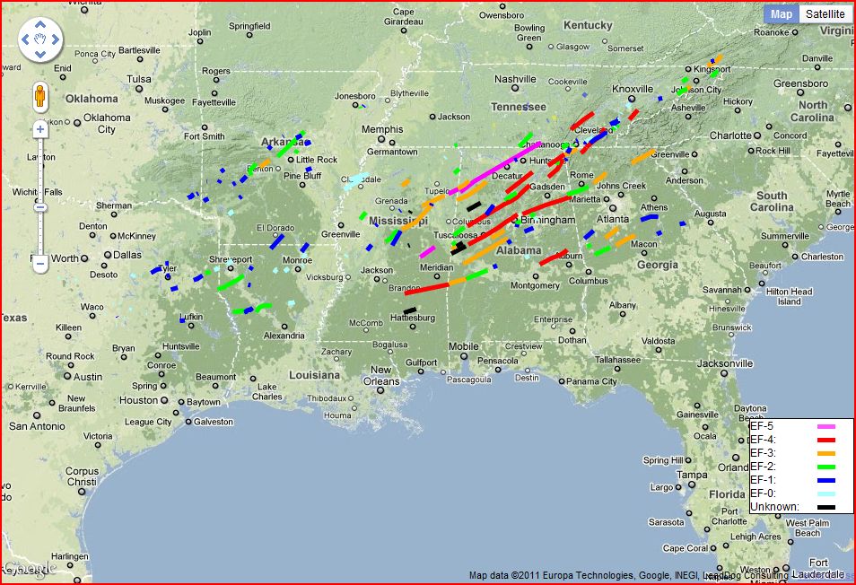


 Images (click to enlarge): Preliminary April 25-28 tornado tracks as of May 6, pavement and turf gouging from the Neshoba County, Mississippi EF-5 tornado, from NWS
As the painstaking work of surveying the damage from the record tornado outbreak continues, the National Weather Service (NWS) announced this afternoon that a second Mississippi tornado on April 27 has been upgraded to EF-5 intensity. The new evaluation of the Neshoba/Noxubee County storm was based on analysis of extraordinary ground damage consistent with EF-5 strength winds: Large sections of sod and asphalt paving were literally ripped out of the ground.
This was the first EF-5 tornado in the area covered by the Jackson, Mississippi NWS office in over 40 years, since Feb. 21, 1971. Along with the previously identified Smithville EF-5, this was the first time since tornado records began that 2 EF-5 tornadoes have been observed in Mississippi on the same day. This also brings to 3 the number of EF-5 storms in the record outbreak of April 25-28, with about two-thirds of the storms surveyed so far.
The total number of confirmed tornadoes in the Jackson region now stands at 31, with
4 EF-0The NWS reports:
10 EF-1
11 EF-2
4 EF-3
1 EF-4
1 EF-5
IN TWO LOCATIONS...THE TORNADO ACTUALLY GOUGED OUT LARGE SECTIONS OF
THE GROUND. IN ONE SPOT IN NORTHEAST NESHOBA COUNTY...THE GROUND WAS
DUG OUT TO A DEPTH OF AROUND 2 FEET OVER AN AREA APPROXIMATELY 25-50
YARDS WIDE AND A COUPLE OF HUNDRED YARDS LONG. SIMILAR GOUGES...
ALTHOUGH NOT AS LONG OR DEEP...WERE ALSO OBSERVED IN EXTREME
NORTHWEST KEMPER COUNTY. WHILE THE EXACT MECHANISM THAT CAUSED THIS
DAMAGE IS UNCLEAR...INDICATIONS ARE THAT THIS TYPE OF GROUND DAMAGE
IS TYPICALLY ASSOCIATED WITH THE EXTREME WIND SPEEDS ASSOCIATED WITH
EF-5 TORNADOES.

IN THE AREA OF NORTHWEST KEMPER COUNTY WHERE THE GROUND GOUGING WAS
OBSERVED...THERE WAS ALSO AN AREA WHERE PAVEMENT WAS REMOVED FROM
THE GROUND. WHILE THIS TYPE OF DAMAGE CAN BE CAUSED BY TORNADOES OF
LESS THAN EF-5 INTENSITY...THE FACT THAT PIECES OF ASPHALT WERE
FOUND AT A SIGNIFICANT DISTANCE AWAY...BOTH UPWIND AND DOWNWIND OF
THE ROAD...ARGUES FOR EXTREME WIND SPEEDS. SIMILAR TYPE DAMAGE WAS
ALSO OBSERVED IN SOUTHWEST NOXUBEE COUNTY.

FINALLY...EXTREME VEHICLE DAMAGE OF THE TYPE NORMALLY ASSOCIATED
WITH EF-5 TORNADOES WAS OBSERVED.  THIS INCLUDED NEW VEHICLES BEING
MOVED MORE THAN 100 YARDS FROM WHERE THEY STARTED...AND BEING LEFT
IN A NEARLY UNRECOGNIZABLE STATE.
Saturday, April 30, 2011
Tornado Update: 2011 More Than Double Previous April Record, Highest Month of All Time, Highest Fatalities of Modern Warning Era
Video (click to play): Raw video of Hackleburg, Alabama destruction from WVTM, Channel 13, Birmingham


 May 2 Update: The National Weather Service has designated the massive Tuscaloosa tornado as a strong EF-4 storm with winds up to 190 mph. The storm caused over 1000 injuries and at least 65 deaths. The path length was a very impressive 80.3 miles, and the damage width was 1.5 miles where it crossed highway I-65. The city of Tuscaloosa still reports 340 missing from the storm.
This storm was one of several strong to violent tornadoes produced by a supercell thunderstorm which began in Newton County, Mississippi at 2:54 pm and dissipated in Macon County, North Carolina around 10:18 pm CDT, covering a total distance of 380 miles in a little under 7.5 hours.
There are at least 2 other EF-4 tornado tracks in the Birmingham NWS office area. (Track map updated.)
May 1 Update: The total number of tornadoes for the April 26-28 event has been revised upward to 312, which is now more than double the previous single-event record. There were an estimated 266 tornadoes in the 24-hour period ending 8 am April 28, which is also a new single-day record.
The Hackleburg, Alabama tornado, previously designated EF-3+, has been confirmed as EF-5, the maximum tornado intensity. Winds were estimated at over 200 mph. The path length was over 25 miles in Marion County, continuing into the Tennessee Valley, with a damage width of 3/4 mile. There were at least 25 deaths from the storm. Several subdivisions, the Hackleburg High School and Wrangler Jeans plant were destroyed. A total of at least 100 structures were destroyed. Motor vehicles were moved 150-200 yards.
A report from the adjoining area serviced by the Huntsville, Alabama NWS office indicates that this tornado continued as an EF-4 into Franklin and Lawrence Counties with a path length of at least 39 miles and 41 fatalities. "Continuous significant devastation" was reported throughout the city of Phil Campbell, including a church completely destroyed with only the slab remaining. Significant devastation also occurred in the areas of Mt. Hope, Langtown, and extreme northwestern Morgan County.
Original post:
As the amazing April 2011 tornado statistics continue to be compiled, the records continue to fall:
- The National Weather Service preliminary count of 288 tornadoes during the event from 8:00 am EDT April 26 to 8:00 am April 28 was nearly double the previous record event of 148 tornadoes on April 3-4, 1974.
- The death toll of 344 is the largest for any tornado event in the modern warning era of radar and satellite imaging. It is the highest number killed in a 2-day period since the 454 deaths on April 5-6, 1936.
- The 334 fatalities in a 24-hour period are the most in a single day since the 747 on March 18, 1925, which includes the infamous Tri-State Tornado.
- The death count of at least 65 from the Tuscaloosa-Birmingham tornado is the highest in a single storm since 80 people died on May 25, 1955 in Kansas.
- The preliminary count of over 600 tornadoes this month is more than double the previous April record of 267 in 1974.
- This also beats the previous all-time monthly record of 542 in May 2003.
- Dade and Walker Counties
- Bartow, Cherokee, and Pickens Counties
- Meriwether, Spalding, and Henry Counties
- Pike, Lamar, Monroe, and Butts Counties
Friday, April 29, 2011
At Least One April 27 Tornado Rated Rare EF-5
May 1 Update: A second tornado, in Alabama, has now been rated EF-5.
April 30 Update: See here for an update on the tornado records being broken.
Original post:
The National Weather Service announced today that at least one of the tornadoes in the major outbreak of April 27 was given a preliminary rating of EF-5, the first one at the maximum intensity in nearly half a century in Mississippi. Damage assessment of the Tuscaloosa, Alabama storm is still ongoing.
AFTER A REVIEW OF THE DAMAGE PHOTOS TAKEN DURING THURSDAY/S GROUND
SURVEY AND CONSULTATION WITH NATIONAL EXPERTS...THE NATIONAL
WEATHER SERVICE IN MEMPHIS HAS UPGRADED THE SMITHVILLE TORNADO
RATING TO EF-5 DAMAGE. THIS IS THE HIGHEST RATING FOR TORNADO
DAMAGE AND THE FIRST EF-5 OR F-5 IN MISSISSIPPI SINCE THE
CANDLESTICK PARK TORNADO NEAR JACKSON ON MARCH 3RD 1966.

* COUNTY/COUNTIES: MONROE

* LOCATION/TIME OF EVENT: SMITHVILLE AT 344 PM EDT

* BEGINNING POINT: 34.0517, -88.4236

* ENDING POINT: 34.0731, -88.3814

* RATING: EF-5

* ESTIMATED PEAK WIND: 205 MPH

* PATH LENGTH: 2.82 MILES

* MAXIMUM WIDTH: 1/2 MILE

* FATALITIES: 14

* INJURIES: 40

* SUMMARY OF DAMAGES: 18 HOMES DESTROYED...2 BUSINESSES /POST
  OFFICE AND POLICE STATION/ DESTROYED...8 HOMES WITH MAJOR
  DAMAGE...7 BUSINESSES WITH MAJOR DAMAGE...44 HOMES WITH MINOR
  DAMAGE...AND WATER SYSTEM DESTROYED. MOST TREES EITHER SNAPPED
  OR TWISTED AND DEBARKED. MOST THE HOMES DESTROYED WERE WELL
  BUILT...TWO STORIES...LESS THAN TEN YEARS OLD AND BOLTED DOWN TO
  THEIR FOUNDATIONS. AN 1965 CHEVY PICKUP TRUCK PARKED IN FRONT
  ONE OF THE DESTROYED HOMES HAS NOT BEEN FOUND. ALL APPLIANCES
  AND PLUMBING FIXTURES IN THE MOST EXTREME DAMAGE PATH SHREDDED
  OR MISSING.
Thursday, April 28, 2011
Record Heat Fuels Historic Tornado Outbreak
Video (click to play): Tuscaloosa, Alabama tornado by Chris England from University of Alabama, via YouTube


 For related record temperature posts, see:
6 PM Update: NCAR Currents has just published an analysis of the factors leading to such a high death toll in yesterday's tornadoes:
Recipe for calamity: The ingredients of a horrific tornado outbreak
The overall death toll has now been reported as 272 across 6 states.
Original post:
OK, let's get the caveat out of the way right up front: No individual temperature ever caused a specific storm.
When a pattern persists over a large area for an extended period of time, however, it's worthy of notice. The latest reports indicate hundreds of people killed, 162 in the state of Alabama alone, from the tornado outbreak which pounded the Southeast yesterday (April 27). The National Weather Service's Storm Prediction Center has a preliminary count of 164 tornado reports for the day and 3 additional reports so far today. This is the culmination of a month which has undoubtedly broken the April tornado record with 453 separate storms tallied by The Weather Channel. This total, which apparently does not yet include the widespread outbreak of April 27, smashes the previous record of 267 in 1974 and approaches the all-time monthly record of 543 set in May, 2003.
Temperature is only one factor in the development of severe storms, but heat provides the energy which makes thunderstorms and their associated tornadoes possible. So far this month, NOAA's National Climatic Data Center reports 1759 record high temperatures in the U.S. vs. 310 record lows, a ratio of nearly 5.7 to 1, exceeding even March's 5.3 to 1. This is the highest since the ratio of 6.1 last April. There have now been 13 out of the last 14 months with more heat records than cold records. The cumulative ratio since January 2010 is 2.2 to 1.
As shown on the map to the right, April temperatures to date have been above the long-term average across much of the U.S., particularly over the southern portion of the country.
Images (click to enlarge):
- Radar image at 10:25 am, April 28, shows showers and thunderstorms stretching almost continuously from the Canadian border southward to the Gulf of Mexico, from Intellicast
- Tornado and severe storm reports for April 27, from Storm Prediction Center
- Monthly total number of daily high temperature, low temperature, and high minimum temperature records set in the U.S. for November 2010 through April 2011, data from NOAA National Climatic Data Center, background image © Kevin Ambrose (www.weatherbook.com). Includes historical daily observations archived in NCDC's Cooperative Summary of the Day data set and preliminary reports from Cooperative Observers and First Order National Weather Service stations. All stations have a Period of Record of at least 30 years.
- Cumulative excess of heat records vs. cold records by month for 2010 and 2011 to date, data source as above
- Preliminary April 2011 monthly temperature departure from climatological average from NOAA/NCEP via ESRL
Monday, April 25, 2011
Hottest Easter Keeps UK on Track for Warmest April on Record


The hottest Easter in at least a century in Britain is keeping this month's temperatures on a pace to break the 2007 record for the warmest April in history. The highest temperature over the weekend was 27.8°C on Saturday at Wisley, in Surrey. In London, the temperature was 27.1°C on Saturday and around 25°C on Sunday, vs. a normal high of 15°C at this time of year.
Over 100,000 people were estimated to have flocked to southern beaches this weekend.
London temperatures this week are forecast to range from a high of 22°C on Monday to a more seasonable 13°C for the Royal Wedding on Friday.
Temperatures in April to date have been well above average over most of Europe, with the highest departures in Spain, France, and Germany.
Images (click to enlarge): Weekend crowds at Brighton beach, England, from UK Guardian; European temperature departures from average for April, 2011 to date, from NOAA/ESRL
Subscribe to:
Posts (Atom)
Seasonal Outlook
Latest seasonal forecast: Click here.

Latest 3-month temperature outlook from Climate Prediction Center/NWS/NOAA.
Latest 3-month temperature outlook from Climate Prediction Center/NWS/NOAA.


