Thursday, March 3, 2011

Minneapolis Snowfall Update: Second Snowiest Winter (December-February) on Record


Image (click to enlarge): Top 5 cumulative seasonal snowfalls to date vs. 2010-11 at Minneapolis, from National Weather Service

March 22, 11 PM CDT Update: The total storm snowfall of 4" to 7" expected through Wednesday would bring the season's total to 84"-87". This could raise the current season to as high as 4th snowiest in Minneapolis history. A minimum of 1.2" would be necessary to reach 6th place, 4.0" to reach 5th place, and 4.8" to reach 4th place. (The current total to date is 80.2".)

March 9 Update: An additional 0.8" through this morning brings the seasonal total to 79.5", putting it in 7th place, behind the 1961-1962 amount of 81.3".

March 7, Noon CST Update: The storm total of 2.1" through this morning puts the seasonal total in sole possession of 8th place with 78.7".

March 6, Midnight CST Update: The 1.7" of snow on Sunday brings the seasonal total to 78.3", still 0.1" below 8th place 1966-67.
The top 10 seasons are:
1983-1984   98.6                                         
1981-1982 95.0
1950-1951 88.9
1916-1917 84.9
1991-1992 84.1
1961-1962 81.3
1951-1952 79.0
1966-1967 78.4
2010-2011 78.3
2000-2001 75.8
March 6 Update: The overall snow season at Minneapolis extends beyond the meteorological winter months of December-February. For the entire season, the 76.6" to date is in 9th place. The record amount was 98.6" in 1983-84, so it would require nearly 2 feet more in the remainder of March and April in order to break the seasonal record.

Original post:
The National Weather Service reports that the 66.7" of snow for the 2010-11 meteorological winter (December-February) was the second largest amount on record at Minneapolis. The record snowiest winter was in 1966-67, when 71.7" fell. It was also the 4th wettest winter on record. The 4.91" of precipitation was 173% of normal.

The average winter temperature at Minneapolis was 1.6° below normal. As the 58th coldest winter, it was near the middle of the range for the 140-year climate history of Minneapolis. The average daily high temperature was 3.0° below normal (36th coldest), but the average low was only 0.1° below normal.

St. Cloud had its 4th snowiest winter on record with 47.5" of snow, and the 4.35" of precipitation was also the 4th wettest on record.

Here are the Minneapolis extreme warmest, coldest, wettest, and snowiest winters, from the National Weather Service (HDD denotes heating degree days):
                            EXTREME      YEAR     DEPART            RANK
DEC-JAN-FEB MAX 36.3 1878 11.1 WARMEST 1 WARM
DEC-JAN-FEB MAX 13.3 1875 -11.9 COLDEST 1 COLD
DEC-JAN-FEB MIN 21.6 1878 12.6 WARMEST 1 WARM
DEC-JAN-FEB MIN -5.8 1875 -14.8 COLDEST 1 COLD
DEC-JAN-FEB MEAN 29.0 1878 11.7 WARMEST 1 WARM
DEC-JAN-FEB MEAN 3.8 1875 -13.5 COLDEST 1 COLD
DEC-JAN-FEB HDD 3240 1878 -1077 WARMEST 1 WARM
DEC-JAN-FEB HDD 5471 1875 1154 COLDEST 1 COLD
DEC-JAN-FEB PRECIP 9.58 1881 6.75 SNOWIEST 1 WET
DEC-JAN-FEB PRECIP 0.69 1958 -2.14 DRIEST 1 DRY
DEC-JAN-FEB SNOW 71.7 1967 40.0 WETTER 1 WET
DEC-JAN-FEB SNOW 5.2 1944 -26.5 DRIER 1 DRY

Wednesday, March 2, 2011

Washington's Winter 2010-11: Stick a Fork In It

With a high temperature of 72° on Monday, February 28, Washington's meteorological winter of 2010-11 ended on a distinctly warm note. The daily high was the 4th one of the month at or above 70°. It was the greatest number of 70° days in February since 1997, when there were also 4. Despite a stretch of 5 consecutive days below average in the second week, the February average temperature of 41.7° was 3.6° above the climatological mean. Although there were 16 days with lows at freezing or below, there were no days with highs below freezing. On average, there are 17 days with lows at or below freezing and 2 such highs.

February is now the 11th month out of the last 14 with above-average temperatures in Washington, following cooler-than-normal readings in December and January. It was the warmest February average since the 42.6° in 2002. Despite the slight dip in December and January, the accumulated temperature departure since January 2010 has rebounded to 30°. Averaged over the 14-month period, that's over 2° above the climatological mean.

For the winter overall, temperatures averaged 0.9° below normal. It was the 3rd consecutive below-average winter in Washington, but 6 out of the 12 winters since 2000 have been above average, and the mean for the century to date is +0.6°.

Despite the relentless pimping of the s-word by certain eyeball-hungry local media outlets, the warm temperatures combined with below-average precipitation of 2.12" to produce a mere 0.5" of snow for the month. The greatest amount in a 24-hour period was 0.2".

As has been noted here in the past, March snow is not unheard of in Washington, with double digit amounts on a few occasions, and the all-time daily record was set as late as the 29th. Nevertheless, the current seasonal total of 9.9" of snow is 28% below the normal amount to date. A snowless March would add about another 10% to that deficit.

Friday, February 25, 2011

San Francisco Snow? (Would Be) Fifth Occurrence in Last Century
Update: No SFO Snow, 1976 Record Holds

Feb. 28 Update: Other than a few flurries, snow failed to materialize in San Francisco. The National Weather Service reports:
As it turns out, a few showers did linger during the early morning hours of February 26th to allow for snow all the way down to sea level. However, only trace snowfall was reported around San Francisco. Therefore the last measurable snowfall in San Francisco still remains 1976. Farther south toward Monterey, light snowfall dustings were also reported. Higher peaks above approximately 2000 feet received more measurable snowfall with a few inches, which is not unusual for this time of year. The overall airmass remained rather unstable during the afternoon of February 26th which resulted in convective rain and snow showers across the region. Several weather spotters reported snow down to sea level once again, but no accumulation was noted.
1:30 PM PST Update: (Headline modified to clarify event is only a possibility.) The latest forecast discussion from the National Weather Service confirms that measurable snow is unlikely below elevations of 500 feet:
 AFTER THE FRONT MOVES THROUGH THE RAIN WILL TURN TO SHOWERS. THE NORTH BAY
MOUNTAINS COULD GET SEVERAL INCHES OF SNOW LATER THIS MORNING INTO
THE AFTERNOON...BUT THE MAJORITY OF THE PRECIPITATION WILL END BY
LATE AFTERNOON NORTH OF THE GOLDEN GATE. THERE COULD BE LIGHT
RAIN/SNOW SHOWERS TONIGHT...WITH SAN FRANCISCO POSSIBLY SEEING SOME
SNOWFLAKES OVERNIGHT...BUT NO ACCUMULATION IS EXPECTED. LOOKS LIKE
THE MAIN AREA THAT HAS THE BEST CHANCE OF SEEING SIGNIFICANT SNOW
WILL BE THE SANTA CRUZ MOUNTAINS AND THE EAST BAY HILLS SOUTH...AND
SOUTH OF THE SANTA CLARA VALLEY IN THE LOWER ELEVATIONS.
Note to Ice Agers: The average change in temperature with height is 5.38°F/1,000 Ft, more when the air is especially cold aloft as in the current situation, so snowfall in the hills doesn't count for any records.

Meanwhile, very heavy rainfall rates have been reported this morning from the storm. A downpour in northeastern San Francisco recorded 0.11" of rain in 5 minutes, a rate of over 1" per hour. Over 2" were reported in 24 hours west of Cupertino.

Original post:
A strong upper-level low pressure area is bringing cold temperatures to the San Francisco Bay area and prompting the National Weather Service to issue a winter weather advisory for elevations above 1000 feet in the North Bay area:
A WINTER WEATHER ADVISORY REMAINS IN EFFECT UNTIL 4 PM PST
FRIDAY.

* SNOW ACCUMULATIONS: 1 INCH 1000 TO 1500 FEET WITH 2 TO 4 INCHES
ABOVE 1500 FEET. 6 INCHES OR MORE FOR ELEVATIONS ABOVE 2500 FEET.

* ELEVATION: HEAVIEST SNOW WILL BE ABOVE 1500 FEET BUT
ACCUMULATING SNOW IS EXPECTED AS LOW AS 1000 FEET.

* TIMING: A MIX OF RAIN AND SNOW WILL CONTINUE THIS EVENING AND
CHANGE TO ALL SNOW OVERNIGHT AS SNOW LEVELS DROP. STEADY PRECIPITATION
WILL CHANGE TO SNOW SHOWERS BY FRIDAY MORNING.
If measurable snow were to occur at sea level, it would be only the 5th such occurrence in the past century, according to Golden Gate Weather Services. Unofficial reports indicate that there were 7 such events in the second half of the 19th century.

H/T: NCAR AtmosNews

Tuesday, February 22, 2011

Minneapolis Sets Single-Storm Snowfall Record

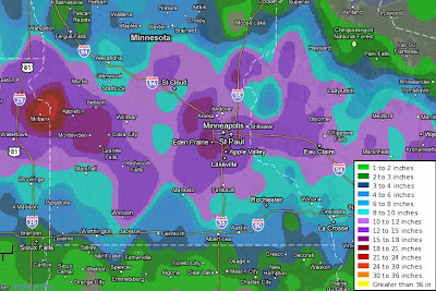
Images (click to enlarge): Feb. 20-21, 2011 total snowfall amounts for metro Minneapolis and for surrounding southern Minnesota and western Wisconsin, from National Weather Service

The 13.8" of snow on February 20-21 in Minneapolis was the largest amount for a single storm in February. It was also the first time more than a foot of snow fell in a single February storm. Some nearby locations reported amounts up to 20".

Of the top 5 February storm totals at Minneapolis, 3 have now occurred in the last 7 years. Climate records at Minneapolis have been collected for 140 years (since 1871).

From the National Weather Service:
Top 5 February Snow Storms for the Twin Cities
1) Feb. 20-21 2011 13.8"
2) Feb. 1-3 2004 11.2"
3) Feb. 19-20 1952 10.5"
4) Feb. 22 1913 8.8"
5) Feb. 24-25 2007 8.7"
The winter snowfall total of 74.9" to date at Minneapolis is now the 10th highest on record for a full season, but it's the 3rd highest to date. The record seasonal total was 98.6" in 1983-84.

The NWS points out that February on average is the least snowiest winter month in Minneapolis. The reason for this is that the upper Midwest is usually dominated by cold high pressure areas in mid-winter. These tend to be relatively dry, and they suppress the prevailing storm track to the south. Except for a stretch of several days in which temperatures failed to rise out of the single digits, this February has been relatively warm at Minneapolis. Through the first 3 weeks, the month has averaged 1.1° above the long-term climatological mean.

Here are some reports of double-digit snow totals from southern Minnesota and western Wisconsin:
20.00   MADISON                  MN  LAC QUI PARLE    0830 PM
19.60 BLOOMINGTON MN HENNEPIN 0825 PM
19.00 3 NW EDEN PRAIRIE MN HENNEPIN 0515 PM
18.00 CREDIT RIVER MN SCOTT 0937 PM
18.00 BURNSVILLE MN DAKOTA 0519 PM
17.50 SPRINGFIELD MN BROWN 0840 AM
16.30 1 SSW MONTEVIDEO MN CHIPPEWA 0700 AM
15.50 2 W PRIOR LAKE MN SCOTT 0900 AM
15.10 LAKEVILLE MN DAKOTA 0814 PM
15.10 RICHFIELD MN HENNEPIN 0820 PM
15.00 OSCEOLA WI POLK 0500 PM
15.00 MENOMONIE WI DUNN 0552 PM
15.00 3 SSW BURNSVILLE MN DAKOTA 0845 AM
14.20 1 N PRIOR LAKE MN SCOTT 0930 PM
14.00 INVER GROVE HEIGHTS MN DAKOTA 1002 PM
14.00 WOODBURY MN WASHINGTON 0800 AM
14.00 EDEN PRAIRIE MN HENNEPIN 0809 PM
14.00 RED WING MN GOODHUE 0730 PM
13.60 ANDOVER MN ANOKA 1024 PM
13.50 MAPLEWOOD MN RAMSEY 1210 PM
13.80 MINNEAPOLIS(MSP AIRPORT) MN HENNEPIN 1240 AM
13.70 CHANHASSEN (NWS OFFICE) MN CARVER 1240 AM
13.30 ST PAUL MN RAMSEY 0610 AM
13.00 GRANITE FALLS MN CHIPPEWA 1013 AM
12.90 3 WNW RICE MN STEARNS 0700 AM
12.70 EDINA MN HENNEPIN 0203 PM
12.70 1 NW BURNSVILLE MN DAKOTA 0700 PM
12.60 COON RAPIDS MN ANOKA 0638 PM
12.50 CARVER MN CARVER 0700 AM
12.40 HASTINGS MN DAKOTA 0907 PM
12.40 ROBERTS WI ST. CROIX 0800 AM
12.30 5 SW ST PAUL MN RAMSEY 0845 AM
12.00 1 N CAMERON WI BARRON 0500 PM
12.00 MANKATO MN BLUE EARTH 0333 PM
12.00 LAKE ELMO MN WASHINGTON 0800 AM
12.00 3 N BLOOMER WI CHIPPEWA 0730 AM
12.00 BALDWIN WI ST. CROIX 0700 AM
12.00 3 SW MINNEAPOLIS MN HENNEPIN 0900 PM
12.00 SHAKOPEE MN SCOTT 0854 PM
11.60 JORDAN MN SCOTT 0710 AM
11.50 MILROY MN REDWOOD 0700 AM
11.10 BLAINE MN ANOKA 0917 PM
11.00 DURAND WI PEPIN 1000 PM
11.00 SAUK RAPIDS MN BENTON 0800 PM
11.00 MORGAN MN REDWOOD 0702 AM
11.00 4 NNE MAPLEWOOD MN RAMSEY 0830 PM
11.00 1 ESE CHASKA MN CARVER 0800 PM
10.60 3 NNW MINNEAPOLIS MN HENNEPIN 0346 PM
10.60 MINNETONKA MN HENNEPIN 0803 AM
10.50 CLAYTON WI POLK 0616 PM
10.50 LITCHFIELD MN MEEKER 0420 PM
10.50 ELK MOUND WI DUNN 0600 AM
10.50 REDWOOD FALLS MN REDWOOD 0500 AM
10.30 7 S HILLMAN MN MORRISON 0335 PM
10.20 OAKDALE MN WASHINGTON 0747 PM
10.00 GLENWOOD MN POPE 0600 PM
10.00 ST JAMES MN WATONWAN 0700 PM
10.00 MADELIA MN WATONWAN 1245 PM
10.00 COMFREY MN BROWN 1210 PM
10.00 BROWNTON MN MCLEOD 1210 PM
10.00 NW GILMAN MN BENTON 0828 AM
10.00 ISANTI MN ISANTI 0626 AM
10.00 EAU CLAIRE WQOW WI EAU CLAIRE 0500 AM
10.00 2 N MENOMONIE WI DUNN 1100 PM
10.00 1 W CARVER MN CARVER 0900 PM
10.00 4 SSW MINNEAPOLIS MN HENNEPIN 0700 PM
10.00 ST PETER MN NICOLLET 0530 PM

Friday, February 18, 2011

Record Temperatures Reach Mid-Atlantic;
120-Year Washington, Baltimore Minimums Broken

Feb. 18 Update: Added more reports for Ohio, New Jersey, New York, Virginia, North Carolina, South Carolina.

Midnight Update: The midnight temperatures are: National 59°, Dulles 55°, and BWI 55°, so the record high minimums hold.

Quantico and College Park are still at 60° and 61°, respectively. On the Maryland Eastern Shore, Ocean City is a summer-like 65°, and Salisbury is 63°.

The National Climatic Data Center preliminary report shows nearly 200 new record highs on Feb. 18 alone. Following a similar number the previous day, the month-to-date count is now almost tied with record lows.

6 PM Update: Nearly all major National Weather Service reporting locations in Pennsylvania tied or broke high temperature records (see list below). Reports to be added as available.

Original post:
Temperatures soared into the 70s for the second consecutive time today in the DMV (DC/Maryland/Virginia) region. The highs of 77° at Washington National and 75° at Dulles were both new records, and the 74° at Baltimore/BWI missed the record by only 1°. The Washington high is 30° above normal.

In addition, the morning lows were all new record high minimums. Assuming they hold through midnight, which appears to be likely, the minimums will break 120-year-old records.

Note that these record high February temperatures, which follow a record hot summer, broke records which followed the previously warmest summer of 1980.

The new records (old records and dates in parentheses) are:
                     High           Low
Washington National 77 (76, 1981) 52 (50, 1891)
Washington Dulles 75 (73, 1981) 53 (50, 1976)
Baltimore/BWI 51 (50, 1891)
More records set or tied in other states:
Zanesville OH    66 (64, 2006)
Youngstown OH 59 (tie, 1994)
Greenville SC 78 (73, 1916)
Raleigh NC 78 (75, 1948)
Greensboro NC 75 (71, 2008)
Charlotte NC 78 (tie, 1891)
Richmond VA 77 (tie, 1976)
Wallops Is. VA 73 (64, 1986)
Danville VA 77 (tie, 1976)
Lynchburg VA 75 (tie, 1927)
Blacksburg VA 65 (tie, 1976)
Roanoke VA 72 (tie, 1971)
Pittsburgh PA 66 (65, 1981)
Williamsport PA 66 (63, 1981)
Harrisburg PA 69 (tie, 1890)
Allentown PA 67 (66, 2008)
Philadelphia PA 69 (tie, 1891, 1890)
Reading PA 71 (70, 1981)
Atlantic City NJ 72 (69, 1981)
Trenton NJ 72 (tie, 1890)
Newark NJ 71 (69, 1981)
Kennedy Airpt NY 67 (57, 1981)
LaGuardia NY 67 (66, 1981)
Binghamton NY 58 (57, 1981)
Image (click to enlarge): U.S. surface temperature map at 3 pm EST, February 18, 2011, shows 70° readings as far north as the Mason-Dixon line (from Unisys)

Thursday, February 17, 2011

Nano Ice Age Update II: Record Temperatures From Kansas to New Jersey

8 PM CST Update: Additional records, including Lincoln, Illinois breaking a century-old record by 4°:
Des Moines IA  68 (tie, 1981)
Lincoln IL 63 (59, 1911)
Peoria IL 64 (tie, 1890)
Springfield IL 68 (67, 1911 and 1890)
Muskegon MI 51 (50, 2008 and 1911)
Zanesville OH 66 (64, 2006)
Beckley WV 66 (63, 1975)
Huntington WV 70 (tie, 1975)
Bluefield WV 66 (65, 1961)
Harrisburg PA 67 (65, 1891)
Binghamton NY 55 (tie, 1981)
Original post:
As warm air spread eastward from the southern Plains, more daily high temperature records were set or tied today across a wide area and by wide margins. In several cases, those margins were as much as 5 degrees in periods of record extending back over a century. For example, Burlington, Iowa, whose observations began in 1897, saw its old record from 1994 smashed by 5° with a reading of 66°.

Rolla, Missouri broke its 1971 record by 4° with a reading of 73°. Records there date back to 1888.

Columbia, Missouri smashed its 1994 record by 6° with a high of 74°. The period of record in Columbia began in 1890.

The St. Louis high of 76° missed a century-old record by only 1°.

Other record reports from the National Weather Service (old record and date in parentheses):
Topeka KS      76 (74, 1913)
Wichita KS 78 (75, 1970)
Moline IL 63 (62, 1981)
Kansas City MO 74 (72, 1970)
Joplin MO 74 (73, 1971)
Trenton NJ 67 (tie, 1976) [records began 1865]
Newark NJ 66 (tie, 1976)
Reading PA 64 (tie, 1976) [records began 1869]
More reports to be added as they become available.

Washington's 2nd February Day of 70°+, 3rd on Tap

Today's high of 72° in Washington was the second this month of 70° or higher, and there's a third one on tap for tomorrow. While unusual, this event is not unique. The last time there were 2 days with 70°+ in February was in 2000. There were 4 such events in 1997.

The record for February since observations began at or near the current location of National Airport in 1930 was 7 in 1976, which benefited from being a leap year. There were 2 spans of 3 consecutive days each: Feb. 16-18 (73°, 79°, and 76°) and Feb. 27-29 (71°, 74°, and 77°). The high was also 71° on Feb. 25 that year.

The chart shows all of the previous years since 1930 with 2 or more 70°+ days in February.

Seasonal Outlook

Latest seasonal forecast: Click here.


Latest 3-month temperature outlook from Climate Prediction Center/NWS/NOAA.