Friday, August 20, 2010

Deja Vu All Over Again: More Nashville Floods

For the second time in a little over 3 months, record rainfall has brought flooding to Nashville and other parts of middle Tennessee. Fortunately, no deaths or serious injuries have been reported, but there have been numerous road closures and water rescues as a result of the downpours.

The National Weather Service reports that Nashville received a storm total of 4.25" in less than 48 hours from Tuesday afternoon through Thursday morning, August 17-19. The 2.49" on Wednesday set a new rainfall record for August 18. Also,
The month-to-date rainfall total now stands at 6.35 inches. Since June 1, a total of 17.17 inches of rain has fallen . . .

For the year, Nashville has seen 47.50 inches of rain. Only two other times has Nashville experienced this much rain by August 19. The last time was in 1950, when 47.84 inches of rain had been recorded through August 19. Before that, we have to go all the way back to 1882, when 53.38 inches had accumulated through August 19.

Normal year-to-date rainfall at Nashville is 31.34 inches, meaning that we`re currently running at 152% of normal. In addition, normal yearly rainfall is 48.11, so the city could actually go dry for the remainder of the year and still end up very close to its normal annual rainfall.
Rainfall amounts as high as 11" or more were reported in other parts of Middle Tennessee (from NWS):
..4.5 MILES NORTH NORTHEAST OF GREEN HILL......  
11.97 INCHES

..3.5 MILES NORTH NORTHWEST OF COOKEVILLE......
11.43 INCHES

..8.7 MILES NORTH NORTHEAST OF CARTHAGE........
11.29 INCHES

..3.8 MILES NORTH NORTHEAST OF GREEN HILL......
10.47 INCHES

..2.9 MILES NORTHEAST OF HENDERSONVILLE........
10.03 INCHES

..1.2 MILES WEST SOUTHWEST OF BELINDA CITY.....
8.85 INCHES

..2.0 MILES WEST NORTHWEST OF LEBANON..........
8.72 INCHES

..0.6 MILES NORTH NORTHEAST OF LEBANON.........
8.29 INCHES

..1.1 MILES EAST OF MOUNT JULIET................
8.24 INCHES

..2.6 MILES EAST NORTHEAST OF COOKEVILLE........
8.15 INCHES

..2.3 MILES EAST SOUTHEAST OF WESTMORELAND......
7.98 INCHES

..LIVINGSTON....................................
7.94 INCHES

..1.7 MILES WEST NORTHWEST OF GALLATIN..........
7.91 INCHES

..6.3 MILES EAST OF GALLATIN....................
7.79 INCHES

..5.4 MILES NORTH NORTHEAST OF WESTMORELAND.....
7.74 INCHES

..4.2 MILES WEST NORTHWEST OF CARTHAGE..........
7.72 INCHES

..0.1 MILES WEST OF CARTHAGE....................
7.71 INCHES

..LEBANON.......................................
7.55 INCHES

..3.7 MILES WEST NORTHWEST OF LEBANON...........
7.39 INCHES

..3.9 MILES EAST OF COOKEVILLE..................
7.36 INCHES

..0.4 MILES NORTHWEST OF MOUNT JULIET...........
6.83 INCHES

..CELINA........................................
6.43 INCHES

..1 MILE WEST OF MOUNT JULIET...................
6.34 INCHES

..4.4 MILES WEST SOUTHWEST OF HERMITAGE.........
6.33 INCHES

..5.8 MILES WEST OF HARTSVILLE..................
6.18 INCHES

..2.7 MILES SOUTH SOUTHEAST OF LEBANON..........
6.02 INCHES

..COOKEVILLE....................................
6.01 INCHES

..6.1 MILES SOUTH SOUTHWEST OF MOUNT JULIET.....
5.93 INCHES

..5 MILES NORTH OF HENDERSONVILLE...............
5.29 INCHES

..WHITE HOUSE...................................
4.77 INCHES

..1.1 MILE SOUTH SOUTHWEST OF GOODLETTSVILLE....
4.56 INCHES
Images (click to enlarge): Road damaged by flash flood in Cookeville, Tenn, Associated Press via Nashville Tennessean; August 17-19 Middle Tennessee precipitation amounts from National Weather Service

Judgment Delayed In Cuccinelli's UVA Climate Witch-Hunt

The Richmond Times-Dispatch reports that a ruling has been delayed in a case regarding Virginia Attorney General Ken Cuccinelli's demand for all documents and emails from the University of Virginia involving climate researcher Michael Mann, who worked at the university from 1999 to 2005. Albemarle County Circuit Court judge Paul Peatross announced this afternoon that he would make a decision on the case within 10 days.

UVA administrators have strongly opposed the Attorney General's subpoena on the basis that it puts a "severe chill on academic freedom and scientific debate." Four organizations have also filed briefs in support of the UVA position. They are: ACLU of Virginia, the American Association of University Professors, the Union of Concerned Scientists and the Albemarle County-based Thomas Jefferson Center for the Protection of Free Expression. Students, faculty, and alumni held a small rally on campus this afternoon to protest the case.

Wednesday, August 18, 2010

BBC Weatherman Gives One-Finger Salute on Air

BBC weathercaster Tomasz Schafernaker was caught live on-camera earlier this week giving his middle-finger reaction (known in German as the Stinkefinger) to a sarcastic introduction by the news anchor:


According to the UK Sun, this is not the first gaffe by the 31-year-old TV weatherman:
Last year he stumbled over his words in a live broadcast and forecast a "muddy sh*te" for Glastonbury instead of a "muddy site".

He was also forced to make an apology after referring to the Outer Hebrides or Western Isles of Scotland as "nowheresville" in a weather bulletin in February 2007.

Early this year Tomasz caused controversy when he posed without his top on for the cover of Active - a supplement in gay magazine, Attitude.
The Beeb itself reported its regrets:
"The News Channel presenter in the studio acknowledged a mistake had been made, and we apologise for any offence caused," a BBC spokesman said.

"Tomasz was not aware that he was on air, and whilst the gesture was only shown for a second, it was not acceptable."
The Guardian's MediaMonkey blog comments
And, you guessed it... Schafernaker again who couldn't stop laughing after BBC News presenter Simon McCoy – him again! – suggested he had a "frozen ball". "Just the one," replied TS. Schafernaker, who as well as predicting warm fronts has quite an impressive front himself (as revealed in Attitude magazine earlier this year) has also been known to break into song, read out the wrong forecast and occasionally make no sense whatsoever.

Monday, August 16, 2010

Summer of Simmer: August Week 2 Update

See here for more Washington, DC weather records

Following highs of 98° and 97° on Tuesday and Wednesday, temperatures cooled through the weekend with highs of only 80° on Friday and Sunday. These were the lowest daily highs since the temperature last failed to reach 80° on June 9. Today is the 68th consecutive day with temperatures of 80° or higher.

Today's preliminary high was 91° after a low so far of 74°. This makes the daily average 5° above average. Friday, August 13, through Sunday, August 15, were the first 3 consecutive days below average since the first 3 days of July, but they were only below average by 1° each.

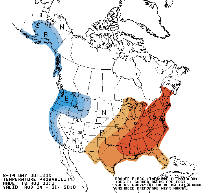
Overall, the August average has declined slightly from its peak to 80.9°, which is 2.4° above average. If it continues at this rate, this month will be the 6th warmest August on record. The summer average to date is 81.6°, which continues well above the previous record pace. If temperatures for the rest of the month merely equal the long-term average, the summer will still easily break the record with a temperature of 80.8°. In fact, however, temperatures in the coming week as well as into the extended range are forecast to be above average.

Images (click to enlarge): Washington, DC average summer temperatures to date for 2010 and previous record years 1980, 1991, 2002, and climatological period 1971-2000; Daily high temperatures, summer 2010 (portion above 90° in dark red); CapitalClimate charts from National Weather Service data, background photo from Kevin Ambrose; 6-10 day and 8-14 day temperature outlooks from Climate Prediction Center/NWS

Sunday, August 15, 2010

Chicago Extends Record Heat Streak to 45 Days

August 18 Update: The streak ended yesterday (August 17) with a high of 79°.

August 16 Update: The National Weather Service notes that today is the 46th consecutive day of 80°+ temperatures at Chicago by listing the 10 longest streaks:
1.   46 DAYS...WITH THE STREAK STILL CONTINUING ON AUGUST 16 2010
2. 42 DAYS...WITH THE STREAK ENDING ON AUGUST 7 1955
3. 34 DAYS...WITH THE STREAK ENDING ON SEPTEMBER 6 1995
4. 32 DAYS...WITH THE STREAK ENDING ON AUGUST 8 1983
5. 30 DAYS...WITH THE STREAK ENDING ON JULY 19 1921
6. 29 DAYS...WITH THE STREAK ENDING ON AUGUST 18 1988
7. 27 DAYS...WITH THE STREAK ENDING ON AUGUST 6 1999
8. 27 DAYS...WITH THE STREAK ENDING ON JULY 14 1966
9. 25 DAYS...WITH THE STREAK ENDING ON AUGUST 15 2007
10. 24 DAYS...WITH THE STREAK ENDING ON JULY 26 2005
Original post:
At 10 am local time today, Chicago reached a temperature of 81°. This is now the 45th consecutive day that temperatures have been 80° or higher at Chicago in a streak which began on July 2. According to Tom Skilling's ChicagoWeatherCenter blog, the city set a record of 28 consecutive days above 80° on July 2-29. Counting temperatures of 80° or higher, the current streak exceeds the 42 days from June 27 to Aug. 7, 1955.

The average temperature of 77.7° in July at Chicago was the 7th warmest on record. July was also a very wet month; the 8.84" of precipitation was the 3rd wettest on record.

The current forecast calls for high temperatures in the low to mid 80s each day through next Saturday.

Wednesday, August 11, 2010

DC Held Heat Hostage: Day 51 of 90°+ Temperatures

1 AM Update: The temperature is still 85°; the new record high minimum goes into the books.

Midnight Update: The midnight (EDT) temperature is down to only 85°, so the record high minimum will most likely hold.

Original post:
Today's preliminary high/low temperatures of 97°/80° at Washington raise the summer average to date another notch to 81.9°. The August average is now 82.0°, 3.2° above average and the second hottest August in history. There have now been 51 days of 90°+ temperatures this year, 46 of them this summer. The summer total is now within 2 of the amount in 2002 and more than double last year's. The record for a calendar year is 67 in 1980.

The high missed the daily record by 3°, but the low, if it holds through midnight (1 am EDT), will break the old record high minimum of 78°. If it occurs, this will be the 4th daily low of 80° or higher this summer, the first time there have been more than 3 80°+ lows in the same year. In all, there have been only 28 such lows since records began at or near the current location of National Airport in 1930. The highest was 84° on July 16, 1983. If no rain showers lower the temperature, as seems likely from the current regional radar, the record will undoubtedly hold. Interestingly, however, on July 20, 1981, an impressive 0.76" fell within the 2 hours of 7 to 9 pm (EDT), but the low temperature for the day was still 80°.

The high of 97° at Washington Dulles was enough to beat the old record of 96° in 1980. Records at Dulles extend back to 1962. Wallops Island, VA, which also has a relatively shorter record (since 1963), beat the old record of 92° in 1977 with a high of 97°.

Tuesday, August 10, 2010

Summer of Simmer: 67-Year Record Tied;
50th Day of 90°+


Evening Update: The monthly and seasonal cooling degree days for Washington continue to run significantly above average, driving up area utility bills:
Today    22 +57%
August 166 +14%
Summer 1205 +33%
2010 1446 +39%
Original post:
Today's preliminary high temperature of 98° at Washington ties the record for August 10 set in 1943. Along with the low so far of 76°, this brings the August monthly average to 81.4°, which is 2.5° above the long-term average. The summer average to date is 81.8°.

The high of 97° at Baltimore was 3° short of the record, and the high of 95° at Washington Dulles was 2° below the record there. The downtown Baltimore high was also 97°.

The high of 97° at Salisbury, MD tied a record set in 1977 in a temperature history dating back to 1900. The high of 99° at Georgetown, DE broke the record of 98° set in 1949. Georgetown records began in 1948.

This is the 45th summer day with a temperature of 90° or higher and the 50th of 2010 including the 5 in April and May. The record is 67 days of 90°+ in 1980.

Seasonal Outlook

Latest seasonal forecast: Click here.


Latest 3-month temperature outlook from Climate Prediction Center/NWS/NOAA.