Wednesday, October 28, 2009

October Rainfall Extremes Set New Record

See here for more Washington, DC weather records.

Nov. 1 Update: An additional 0.13" on Halloween brings the final monthly total to 5.71", or 2.49" above average. Here are the monthly, seasonal, and year-to-date totals for the region:
Washington National 5.71"/9.02"/35.68"
Washington Dulles 5.70"/7.53"/38.93"
Baltimore BWI 6.24"/9.72"/42.57"
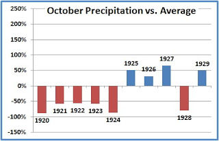
PM Update: Added chart of October 1920-29.

Original post:
With 1.23" of rainfall yesterday, and an additional 0.79" through this morning, the preliminary October rainfall total for Washington stands at 5.59", over 70% above the long-term average for the month. This precipitation excess caps off a decade of October extremes. The 0.02" in 2000 was the second lowest since records began in 1871, and the 9.41" in 2005 was the record highest.

The last 5 consecutive Octobers, and 8 out of the decade 2000-2009, have all been at least 50% above or below the long-term average. The only other decade in which there have been more than 6 such extremes was the 1920s, when there were also 8. This decade's extremes have all been at least +/-55% of average, however, whereas 1925 barely made the 50% level at 50.9%.

Of the 8 extreme Octobers this decade, 5 have exceeded on the up side and 3 on the down side. The 1920s, on the other hand, excelled on the dry side, with 6 of the 8 extreme months below average.

Image (click to enlarge): Washington, DC October 2000-2009 precipitation percentage above or below average; CapitalClimate chart from NWS data

Monday, October 26, 2009

Washington, DC Precipitation Update: Deep Deficit to Solid Surplus

See here for more Washington, DC weather records.

October 27 Update: The 0.63" from last night through this afternoon brings the monthly total to almost 50% above the average to date. Current month-to-date totals:
Washington National  4.18"
Washington Dulles 4.38"
Baltimore (BWI) 4.85"
Original post:
The nearly 1" of rain which fell on Friday and Saturday, combined with the heavier amount the preceding weekend, has moved October's precipitation in the Washington, DC area from the large deficit of the first half of the month to a solid surplus. The month-to-date total of 3.55" at Washington National is 37% above the average through the 25th and is above the average for the entire month. Along with the 1"+ amounts forecast for the upcoming 5 days ending on Halloween, October has a good chance of joining April, May, and June in being 50% or more above normal.

Here are the storm total, month-to-date, and year-to-date precipitation amounts for the region:
Washington National  0.92"/3.55"/33.52"
Washington Dulles 1.73"/4.03"/37.26"
Baltimore (BWI) 1.00"/4.31"/40.64"

Friday, October 23, 2009

President Obama's MIT Energy Speech

President Obama's energy speech at MIT is now being webcast live. Rebroadcast will be available shortly after the speech. [Update: streaming rebroadcast is now available at the link.]

In the relatively short speech (about 15 minutes) to an enthusiastic audience, the President focused on the economic need for clean and sustainable energy, but he also mentioned the overwhelming body of scientific evidence regarding climate change:
The naysayers, the folks who would pretend that this is not an issue, they are being marginalized. But I think it’s important to understand that the closer we get, the harder the opposition will fight and the more we’ll hear from those whose interest or ideology run counter to the much needed action that we’re engaged in. There are those who will suggest that moving toward clean energy will destroy our economy — when it’s the system we currently have that endangers our prosperity and prevents us from creating millions of new jobs. There are going to be those who cynically claim — make cynical claims that contradict the overwhelming scientific evidence when it comes to climate change, claims whose only purpose is to defeat or delay the change that we know is necessary.
The full text of the speech is available here.

The speech followed a tour of MIT's energy research laboratories.

Photo from The Tech, "MIT's oldest and largest newspaper & the first newspaper published on the web"

Wednesday, October 21, 2009

Movie Weather

The Weather Channel announced yesterday that it will start a Friday night movie series, adding full-length motion pictures to its programming:
For the first time in its 27-year history, The Weather Channel® (TWC) will add movies to its programming schedule with "The Weather Channel Presents..." This new movie series launches Friday, October 30, with the TWC premiere of The Perfect Storm, starring George Clooney, which coincides with the anniversary of the ferocious "perfect storm" of 1991, on which the movie was based.

Following The Perfect Storm on Oct. 30, TWC will air feature films every Friday night in November. Weather plays a central role to the story, plot or overall theme in each of the movies selected.
Local weather will be displayed during the movies in the lower portion of the screen.

The scheduled movies include:
  • The Perfect Storm - Premieres Friday, Oct. 30
  • March of the Penguins - Premieres Friday, Nov. 6
  • Misery - Premieres Friday, Nov. 13
  • Deep Blue Sea - Premieres Friday, Nov. 20
Tomorrow's NYT Arts section tomorrow briefly asks why "Twister" is not on the schedule, but apparently negotiations for the rights to display it are underway.

If they're really serious about this, they need to add "Groundhog Day" as well.

"Perfect Storm" cover image from Amazon.com

Monday, October 19, 2009

NewsHour Features Greenland Ice Core Report

Tonight's PBS NewsHour features a report on Greenland ice core analysis:
In July of 2009, Climate Central senior research scientist Heidi Cullen traveled to Greenland with a production team from StormCenter Communications to visit the North Greenland Eemian Ice Drilling Project, or NEEM. Scientists from 14 nations gather together each summer in northern Greenland, where they work to drill a core of solid ice, looking into the past for clues to future climate change.

The NEEM scientists are focused on a period known as the Eemian, which began about 130,000 years ago and lasted about 10,000 years. During the Eemian, temperatures were between 5 and 9 degrees F warmer than today, and global sea level was 13 to 20 feet higher. Under many climate change scenarios, global temperatures are projected to warm a similar amount this century, so understanding the climate of the Eemian could teach us more about the potential effects of warming today.

Means, Extremes, and Hype-ocracy

October 21 Update:
If the term "weather weenie forum" seems a bit harsh, consider the responses when it was pointed out that the original claim was incomplete, misleading, and therefore possibly subject to misuse. First, the comment posted in the forum:
Not strictly correct as stated:
Means, Extremes, and Hype-ocracy [link to this original post]
Some of the responses:
Nobody implied anything about global warming with the stats....Paranoid much, Steve?

He'll get to it in a minute as soon as his dial-up starts working again

:lol:
Who the Hell are you?

I vote capital punishment for capitol climate. :bike:

He's not a big fan when you question him about his beliefs.

Original post:
Weather geeks love their numbers, and to paraphrase Dr. Freud, "Sometimes a stat is just a stat." With the political polarization of the global warming issue, however, things can sometimes get a little out of hand. As noted here previously, a recent remarkably dank spell has led to several record low maximum temperatures here in the National Capital region, including 2 successive records on Friday and Saturday (October 16 and 17).

Quoting a weather weeenie forum, the earnest young lads at the WaPo's local weather blog have overstated the case: "This was the first time DCA has had back-to-back record low highs in October since 1891." Undoubtedly, this has already made it to the climate deniosphere in some such form as, "WaPo reports global cooling back to 1891 levels." Unfortunately, as is usually the case, the more accurate statement is a lot less sexy: "Of the currently existing record low maximums at Washington, DC for October, the only others on consecutive days were in 1891."

The significant point about extreme records is that they are cumulative. It's a lot easier to set records in the early years because there are fewer previous values to exceed. Therefore, records should become less frequent as time goes by. That means that the 2 consecutive records this year are significant, but not as much as the quote would indicate. A couple of minutes with Excel™, the Swiss Army Knife™ of Data Analysis shows at least one contradictory example nearly 50 years more recently. Consider the record low max of 42° for tomorrow, October 20. It was set in 1940. The current record for today is 45° in 1972. What was the second lowest? It was 46° in 1940, so that was the previous record, and back-to-back records were set in 1940 on the 19th and 20th. There was also at least a third record set in 1940, on the 16th (the one that was broken on Friday).

On the other hand, the October average to date (through the 18th) in 1940 was 59.9°, 1.8° above the average so far this year of 58.1°. Even with declining averages in the next couple of weeks, that's still a long way, though, from the record cold October of 50.7° in 1876 or the 52° tie in 1907, 1917, and 1925.

Besides being tied for the second coldest October, 1925 is also the currently reigning champ for record low maximums; it holds 4 daily records on the 10th, 22nd, 29th, and 31st. Although the daily data are not readily available that far back, those records on the 29th and 31st suggest strongly that 1925 set a third consecutive record on the 30th as well. Interestingly, that month was much more extreme on the high side than the low side, since no currently existing record daily low minimums were set in October that year.

Friday, October 16, 2009

Record Cool Mid Atlantic Maximums

For other record temperature posts, see:
Record Heat
Record Cold


Midnight Update: National appears to have held at 45° and Dulles at 44° through midnight.

October 16 Update:
Nationwide, the total number of new or tied daily temperature records reported so far in October by the National Climatic Data Center:
Highest maximum: 573
Lowest minimum: 1,507

The preliminary high today at Washington National of 45° is 23° below average. If it holds through this evening, it will break the old record low maximum record of 51° set in 1940. This is one of the last 3 dates in the remaining portion of the year with record cool highs above 50°. The monthly record low maximum is 40° on the 23rd.

The high of 44° at Washington Dulles will also most likely break the record of
53° set in 1974.

Another record report for today:
THE HIGH TEMPERATURE AT SALISBURY WAS 53 DEGREES TODAY. THIS   
ESTABLISHES A NEW RECORD LOW MAXIMUM TEMPERATURE FOR OCTOBER 16...
BREAKING THE PREVIOUS RECORD OF 56 DEGREES SET BACK IN 1937
Additional reports for October 15:
THE HIGH TEMPERATURE IN ROANOKE VIRGINIA ON OCT 15TH WAS ONLY 48   
DEGREES. THIS SET A NEW RECORD FOR LOWEST MAXIMUM TEMPERATURE FOR
THE DATE. THE PREVIOUS RECORD WAS 53 DEGREES SET IN 2002.

THE HIGH TEMPERATURE IN LYNCHBURG VIRGINIA ON OCT 15TH WAS ONLY 47
DEGREES. THIS SET A NEW RECORD FOR LOWEST MAXIMUM TEMPERATURE FOR
THE DATE. THE PREVIOUS RECORD WAS 52 DEGREES SET IN 2002.

THE HIGH TEMPERATURE IN DANVILLE VIRGINIA ON OCT 15TH WAS ONLY 51
DEGREES. THIS SET A NEW RECORD FOR LOWEST MAXIMUM TEMPERATURE FOR
THE DATE. THE PREVIOUS RECORD WAS 52 DEGREES SET IN 2002.

THE HIGH TEMPERATURE IN BLACKSBURG VIRGINIA ON OCT 15TH WAS ONLY 46
DEGREES. THIS SET A NEW RECORD FOR LOWEST MAXIMUM TEMPERATURE FOR
THE DATE. THE PREVIOUS RECORD WAS 52 DEGREES SET IN 1977.

A RECORD LO-MAX TEMPERATURE OF 55 DEGREES WAS SET AT RALEIGH-DURHAM
INTL AIRPORT NC TODAY. THIS BREAKS THE OLD RECORD OF 57 SET IN 1945.

A RECORD LO-MAX TEMPERATURE OF 53 DEGREES WAS OBSERVED AT PIEDMONT TRIAD INTL
AIRPORT NC TODAY. THIS TIES THE OLD RECORD OF 53 SET IN 2002.

Original post:
A cold rain contributed to record low maximum temperatures in the Mid Atlantic region on Thursday (October 15):
THE HIGH TEMPERATURE AT RICHMOND INTERNATIONAL AIRPORT WAS 54   
DEGREES TODAY. THIS ESTABLISHES A NEW RECORD LOW MAXIMUM TEMPERATURE
FOR OCTOBER 15...BREAKING THE PREVIOUS RECORD OF 56 DEGREES SET
BACK IN 1939.
A statement has not yet been issued by the National Weather Service, but the high of 49° at Washington Dulles was also a record, easily beating the 55° in 1978.

Seasonal Outlook

Latest seasonal forecast: Click here.


Latest 3-month temperature outlook from Climate Prediction Center/NWS/NOAA.