Friday, March 9, 2012

Kentucky Tornado Upgraded to EF-4; Only Second Equivalent March Storm in State


The National Weather Service late this afternoon upgraded the status of the March 2 tornado near Crittenden and Piner, Kentucky to EF-4. According to National Climatic Data Center records, this is only the second tornado of EF-4/F-4 intensity to occur during March in the state of Kentucky. The previous one, on March 4, 1964 caused 3 deaths and 24 injuries in Calloway and Marshall counties. From the NWS summary:
LOCATION...CRITTENDEN AND PINER IN GRANT AND KENTON COUNTY KENTUCKY
DATE...MARCH 2 2012
ESTIMATED TIME...430 PM EDT
MAXIMUM EF-SCALE RATING...EF4
ESTIMATED MAXIMUM WIND SPEED...175 MPH
MAXIMUM PATH WIDTH...ONE HALF MILE
PATH LENGTH...10 MILES
BEGINNING LAT/LON...38.791N/84.633W
ENDING LAT/LON...38.8324N/84.459W
* FATALITIES...4
* INJURIES...8

IMMEDIATELY AS THE TORNADO CROSSED FROM WEST TO EAST OF INTERSTATE
75...THE STORM STRENGTHENED TO EF4 LEVEL WITH WINDS ESTIMATED AT 175
MPH. WHILE A TOTAL OF FIVE SINGLE FAMILY HOMES WERE DESTROYED TO
THEIR FOUNDATIONS IN THE AREA...AT LEAST TWO OF THESE HOMES MET THE
EF4 CRITERIA OF SUFFICIENT FOUNDATION STRAPPING/BOLTING.

ALL 4 FATALITIES WITH THIS TORNADO OCCURRED WITHIN THE AREA OF EF4
LEVEL DAMAGE.

THE EF4 LEVEL DAMAGE WAS FOUND FROM THE EAST SIDE OF INTERSTATE 75
TO THE NORTH END OF OLD LEXINGTON PIKE...WHERE 2 HOMES AND MULTIPLE
OUTBUILDINGS WERE COMPLETELY DESTROYED. BOTH HOMES WERE BRICK
STRUCTURES WITH FOUNDATION BOLTING OR STRAPPING. THE EF4 LEVEL WINDS
CONTINUED ACROSS ROUTE 25/DIXIE HIGHWAY...AND ENDED NEAR THE BAGBY
ROAD AREA. AT LEAST 2 VEHICLES WERE CARRIED...WITH ONE CARRIED OVER
1800 FEET. TREES WERE STRIPPED OF NEARLY ALL BRANCHES...WITH MUCH OF
THE BARK ALSO STRIPPED.
Image (click to enlarge): EF-4 tornado track near Crittenden and Piner, Kentucky, March 2, 2012, from National Weather Service

Record High Temperatures in Central/Northern New England


Most of the major National Weather Service climate reporting locations from northeastern New York through central and northern New England observed record high temperatures yesterday (March 8). Listed by state, the records set or tied included:
State   Location Record Previous/Date Period of Record
MA BOSTON 68 67 3/8/1995 92
MA BLUE HILL 65 63 3/8/1995 119
MA WORCESTER 64 64 3/8/1987 63
ME HOULTON 62 55 3/8/1995 61
ME PORTLAND 60 56 3/8/2010 92
ME AUGUSTA 59 56 3/8/1987 63
ME BANGOR 59 52 3/8/2010 66
ME CARIBOU 58 50 3/8/1995 72
NH CONCORD 66 66 3/8/1995 90
NY GLENS FALLS 65 59 3/8/2000 66
NY MASSENA 60 59 3/8/1995 63
VT MONTPELIER 61 57 3/8/1987 63
VT BURLINGTON 61 61 3/8/2000 106
Image (click to enlarge): Daily high temperature records set or tied on March 8, 2012, from National Climatic Data Center

Tuesday, March 6, 2012

Deluge "Obliterates" Hawaii Rainfall Record

The National Weather Service reports that the 8.64" of rainfall at Lihue, Hawaii yesterday "obliterates" the old daily record for March 5 of 1.14" set in 1974. The 3.31" on Sunday was also a record for March 4. According to NWS records, the all-time daily rainfall record at Lihue was 6.71" on March 14, 2006. Official climate records in Lihue began in 1946. In the 3 days from March 3 through 5 Lihue reported 12.76" of precipitation. Some other rainfall reports from Kauai and Oahu as of Monday afternoon:
KAUAI  
/HNIH1/ HANALEI 26.95
/WLLH1/ MOUNT WAIALEALE RAINGAGE 24.44
/WLDH1/ WAILUA DITCH - USGS 22.66
/WNHH1/ PH WAINIHA 21.63
/KPIH1/ KAPAHI 16.68
/WUHH1/ WAILUA UH EXP STN 14.02
/LIHH1/ LIHUE VRTY STA 12.40
/KLOH1/ KILOHANA RG - USGS 12.11
/HLI / LIHUE AIRPORT 9.88
/ANHH1/ ANAHOLA NO.2 8.86
/MLDH1/ MOLOAA DAIRY 8.32
/WLGH1/ WAIALAE RG - USGS 4.42
/OMAH1/ OMAO 4.29
/KHEH1/ KALAHEO 4.26
/KOKH1/ KOKEE 3.48
/HBK / BARKING SANDS ASOS 3.31
/MCRH1/ MOHIHI CROSSING - USGS 3.28
/WKRH1/ WAIAKOALI - USGS 3.17

OAHU
/PNSH1/ PUNALUU STREAM - USGS 12.65
/OFRH1/ OAHU FOREST NWR 11.35
/MOGH1/ MOANALUA - USGS - USGS 10.37
/KNRH1/ KAHANA STREAM RG - USGS 9.12
/WPPH1/ WAIHEE PUMP 8.78
/AHUH1/ AHUIMANU LOOP 8.10
/NUUH1/ NUUANU UPPER 7.92
/LULH1/ LULUKU 7.42
/WITH1/ WILSON TUNNEL 6.70
/WHSH1/ WAIAHOLE STREAM - USGS 5.14
/HNG / KANEOHE MCAS 5.06
/STVH1/ ST. STEPHENS SEMINARY 4.88
/MAUH1/ MAUNAWILI 4.85
/HNL / HONOLULU AIRPORT 4.78
/HAKH1/ HAKIPUU MAUKA 4.78
/KTAH1/ KAHUKU TRAINING AREA 4.60
/KAHH1/ KAHUKU 3.79
/OFSH1/ OLOMANA FIRE STN 3.76
/KFWH1/ KII 3.25
/WMLH1/ WAIMANALO NONOKIO 3.13

Monday, March 5, 2012

Second Warmest Winter in 80 Years at Chicago, Warmest at Fargo, Top 10 Elsewhere in Midwest

The National Weather Service reported this morning that the winter of 2011-12 was the second warmest in 80 years at Chicago and tied for the 9th warmest overall. It was also the warmest in records dating back to 1881 at Fargo. As shown in the chart from the Midwest Regional Climate Center, temperatures ranged as much as 9° above normal in the upper Midwest.
CHICAGO...

THE WINTER HAD AN AVERAGE TEMPERATURE OF 32.8 DEGREES...WHICH WAS
6.4 DEGREES ABOVE NORMAL. THIS TIES THE WINTER FOR THE 9TH WARMEST
IN THE PAST 140 YEARS (SINCE 1872)...AND WAS THE SECOND WARMEST
WINTER IN THE PAST 80 YEARS. THIS WAS THE WARMEST WINTER SINCE
1997-1998.

RANK WINTER AVERAGE WINTER TEMP
---------------------------------------
1. 1877-1878 37.2
2. 1931-1932 35.7
3. 1879-1880 35.2
1881-1882 35.2
5. 1889-1890 34.7
6. 1875-1876 33.6
7. 1997-1998 33.2
8. 1918-1919 33.1
9. 2011-2012 32.8
1920-1921 32.8


ROCKFORD...

THE WINTER HAD AN AVERAGE TEMPERATURE OF 30.2 DEGREES...WHICH WAS
6.0 DEGREES ABOVE NORMAL. THIS RANKS THE WINTER AS THE 3RD WARMEST
ON RECORD IN THE PAST 106 YEARS (SINCE 1906). THIS WAS THE WARMEST
WINTER SINCE 2001-2002.

RANK WINTER AVERAGE WINTER TEMP
---------------------------------------
1. 1931-1932 32.0
2. 2001-2002 30.9
3. 2011-2012 30.2
4. 1997-1998 30.1
1920-1921 30.1
6. 1930-1931 29.9
7. 1982-1983 29.2
8. 1991-1992 29.0
9. 1908-1909 28.7
10. 1943-1944 28.5

CITY RANK
------------------------------
CHICAGO IL 9TH WARMEST
CLEVELAND OH 7TH WARMEST
FARGO ND WARMEST
GRAND RAPIDS MI 2ND WARMEST
GREEN BAY WI 2ND WARMEST
KANSAS CITY MO 7TH WARMEST
MILWAUKEE WI 4TH WARMEST
MINNEAPOLIS MN 4TH WARMEST
ROCKFORD IL 3RD WARMEST
ST LOUIS MO 6TH WARMEST

Indiana/Kentucky Tornado Areas Hit With 4-5" of Snow

Some of the same areas in Indiana and Kentucky hit with strong tornadoes on Friday got 4-5" of snow, with some higher amounts, Sunday night into Monday morning (maps from National Weather Service, click to enlarge):


Southern Indiana EF-4 Tornado Occurred a Month Earlier Than Only Previous Comparable Event


The National Weather Service reports this evening that the March 2 EF-4 tornado in Washington, Jefferson, and Clark counties in Indiana had a total track length of 49 miles with a maximum path width of as much as half a mile. It appears that this storm, although a month earlier, was at least comparable to the only other recorded event of similar magnitude in that region. The infamous outbreak of April 3-4, 1974, the worst in U.S. history up to that point, was the only previous event with F-4 or stronger tornadoes in those 3 counties since official records began in 1950, according to NOAA/NCDC historical data.

Image (click to enlarge): Track of southern Indiana EF-4 tornado on March 2, 2012, from National Weather Service; Indiana county map from digital-topo-maps.com

Sunday, March 4, 2012

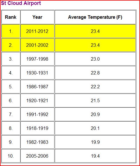
Top 5 Warmest Winter in Minnesota, Western Wisconsin

The National Weather Service reports that the winter of 2011-12 was in the top 5 warmest in much of Minnesota and western Wisconsin. St. Cloud, Minnesota tied the warmest winter temperature on record. The top 10 warmest data from Minneapolis, St. Cloud, and Eau Claire:


Seasonal Outlook

Latest seasonal forecast: Click here.


Latest 3-month temperature outlook from Climate Prediction Center/NWS/NOAA.