Thursday, May 19, 2011

Climate Amplification: Record Wet Spring in Northeast


May 20, 5 pm EDT Update: The additional 0.19" at Buffalo today brings the monthly total to 5.23", which is over 250% of normal. The seasonal record is extended to 15.55".

Burlington's 0.39" so far today raises the May total to 5.09" and extends the spring record to 16.36".

1:40 am EDT Update: Burlington received another 0.22" of rain on Thursday, bringing the month to date total to 4.70" and extending the season to date record to 15.97".

Original post:
Although persistent heavy rainfall in the Ohio Valley has gotten most of the attention, since it feeds into the record flooding of the Mississippi River, excessive precipitation has extended well into the Northeast. Portions of northern Pennsylvania, northeastern New York, and northern Vermont have experienced over 300% of average rainfall in the last 30 days. With nearly 2 full weeks remaining in meteorological spring (March-April-May), some major reporting stations have had their wettest spring on record.

At Buffalo, where climate records extend back to 1871, the National Weather Service reported last night,
THE 1.12 INCHES OF RAIN THROUGH 9 PM THAT FELL ACROSS THE BUFFALO
AIRPORT MAY 18TH SET A NEW SPRING PRECIPITATION RECORD WITH 15.34
INCHES. THIS ECLIPSES THE ALL TIME SPRING (MAR-MAY) RECORD OF 14.90
INCHES SET BACK IN 1991. (30-YEAR AVERAGE IS 9.38 INCHES). MORE
SHOWERS WILL INCREASE THIS TOTAL FURTHER BEFORE THE END OF THE
MONTH.
The final total for the day was 1.14", which broke the daily record of 0.99" in 1904. That was the second daily rainfall record this week, following the 1.33" on Sunday, May 15, which broke the record of 1.31" set in 1886.

The spring rainfall record was already broken on Monday at Burlington, Vermont:
AS OF 5 PM EDT...TOTAL PRECIPITATION FOR METEOROLOGICAL SPRING 2011
WAS 15.62 INCHES WHICH SURPASSED THE OLD RECORD OF 15.46 INCHES THAT
WAS SET IN 1983.

PRECIPITATION BY MONTH FOR METEOROLOGICAL SPRING 2011 INCLUDE:
MARCH 2011 - 3.39 INCHES
APRIL 2011 - 7.88 INCHES (WETTEST APRIL ON RECORD)
MAY 2011 - 4.35 INCHES (AS OF 5 PM EDT 5/16)
Burlington records extend back to 1884.

At Syracuse, the 8.53" in April was a new record for the month in a climate history which began in 1902. This immediately follows the driest April on record in 2010.

Image (click to enlarge): 30-day precipitation percentage of normal ending 8 am EDT, May 19, 2011, from National Weather Service

Energy Market Shrugs Off NOAA's Above-Normal 2011 Hurricane Season Outlook

May 20 Update: Dr. Gerry Bell, NOAA's lead seaosnal hurricane forecaster, conducted an online chat at USA Today's Science Fair blog this afernoon.

Original post:
NOAA's Climate Prediction Center announced its 2011 Atlantic hurricane season outlook at 11:30 this morning, calling for an above-normal level of activity:
  • 12 to 18 named storms (winds of 39 mph or higher), of which:
  • 6 to 10 could become hurricanes (winds of 74 mph or higher), including:
  • 3 to 6 major hurricanes (Category 3, 4 or 5; winds of 111 mph or higher)
The major factors affecting the tropical season include:
  • Reduced wind shear and lower surface pressure over the tropical Atlantic
  • Higher pressure in the upper atmosphere over the eastern Atlantic
  • Warmer Atlantic sea surface temperatures
  • Stronger African easterly jet stream

As this video from CNBC at 11:45 shows, Mr. Market couldn't care less. "Til it happens, we're just going to play it by ear", said a veteran trader.


If you think the market mechanism is a rational way to set energy policy, have I got a deal for you:

Note that the horizontal scale covers just a little over 2 and a half hours. The offering price for LinkedIn was $45. This is for a company which has no earnings and revenues which are about 1/30 of the IPO offering price.

Update: From someone who should know a thing or two about Internet bubbles, Henry Blodgett, see:
CONGRATULATIONS, LINKEDIN! You Just Got Screwed Out Of $130 Million

If at First You Don't Secede: South Carolina Stands Up for Incandescent Bulb Rights

The Colbert Report has the full details on South Carolina commemorating the 150th anniversary of the War of Yankee Aggression by standing up for the right to incandescent light. South Carolina has proven it "knows how to run a black market."

The Colbert ReportMon - Thurs 11:30pm / 10:30c
If at First You Don't Secede
www.colbertnation.com
Colbert Report Full EpisodesPolitical Humor & Satire BlogVideo Archive

Wednesday, May 18, 2011

Massive Wildfires in Alberta Impact Oil Production


CNBC reported this morning (click image to view video) that massive wildfires in Alberta, Canada, fueled by high winds and very dry conditions, have forced some oil operations in the province to shut down. The fires, which at the peak numbered over 100, have burned entire towns to the ground. The town of Slave Lake, population 7000, has been one-third destroyed, with all residents evacuated.

The government reported on Wednesday that 87 fires were still burning, with 23 out of control, including the one in Slave Lake.

Slave Lake temperatures in the past week have been well above the May average of 9.7°C. The May total precipitation to date of 4.5 mm. is barely over 10% of the normal monthly total of 40.9 mm.; no more than 1 mm. has fallen on any individual day this month.

More video (click to play) from AP, via Google News:


More videos and images at Alberta News.

Image to right above (click to enlarge): May 2011 daily average temperature at Slave Lake, Alberta, Canada, from Weather Office/Environment Canada

Tuesday, May 10, 2011

Record Heat in Kansas, Missouri, Oklahoma; Earliest 100° at Wichita
Update: Century-Old Records Also Broken By Wide Margin in Nebraska, Iowa

See Record Heat for the latest updates.

May 11, 2 PM Update: The preliminary report from the National Climatic Data Center shows 186 high temperature records set on May 10, vs. 8 new lows (click image to enlarge):


May 10, Midnight Update: Some more records from Iowa, Nebraska, South Dakota, Kansas, Texas, and Louisiana:
THE FINAL HIGH TEMPERATURE OF 96 DEGREES AT 532 PM CDT IN SIOUX CITY   
BROKE THE RECORD OF 90 DEGREES...SET IN 1987.

THE FINAL HIGH TEMPERATURE OF 95 DEGREES AT 408 PM CDT IN SPENCER
BROKE THE RECORD OF 93 DEGREES...SET IN 1987.

THE FINAL HIGH TEMPERATURE OF 96 DEGREES AT 455 PM CDT IN STORM LAKE
BROKE THE RECORD OF 87...LAST SET 1987...BUT ALSO OCCURRING IN 1963
AND 1911.

THE HIGH TEMPERATURE UP TO 342 PM CDT IN SIOUX CENTER WAS 94
DEGREES. THIS BROKE THE RECORD OF 92...SET IN 1987.

A RECORD HIGH TEMPERATURE OF 92 DEGREES WAS SET AT BURLINGTON TODAY.
THIS BREAKS THE OLD RECORD OF 88 SET IN 1956.

A RECORD HIGH TEMPERATURE OF 91 DEGREES WAS SET AT NORFOLK, NEBRASKA
AT 6:03 PM CDT TODAY. THIS BREAKS THE OLD RECORD OF 89 SET IN 1915.

A RECORD HIGH TEMPERATURE OF 95 DEGREES WAS SET AT LINCOLN, NEBRASKA
AT 5:15 PM CDT TODAY. THIS BREAKS THE OLD RECORD OF 93 SET IN 1962.

A RECORD HIGH TEMPERATURE OF 97 DEGREES WAS SET AT OMAHA EPPLEY,
NEBRASKA AT 5:52 PM CDT TODAY. THIS BREAKS THE OLD RECORD OF 93 SET
IN 1962.

THE HIGH TEMPERATURE UP TO 3 PM CDT IN VERMILLION SOUTH DAKOTA WAS
94 DEGREES. THIS BROKE THE PREVIOUS RECORD OF 92 DEGREES...SET IN
1987.

A RECORD HIGH TEMPERATURE OF 92 DEGREES WAS SET AT TOPEKA KS TODAY.
THIS BREAKS THE OLD RECORD OF 90 SET IN 1911.

...DAILY RECORD HIGH TEMPERATURE RECORDS TIED FOR THE DATE OF MAY
10TH...

LOCATION OLD RECORD NEW RECORD YEARS OF DATA
-----------------------------------------------------------------
LUFKIN TX 93 IN 2008 93 IN 2011 RECORDS SINCE 1906

...DAILY RECORD HIGH TEMPERATURE RECORDS BROKEN OR TIED FOR THE DATE
OF MAY 9TH...

LOCATION OLD RECORD NEW RECORD YEARS OF DATA
-----------------------------------------------------------------
SHREVEPORT LA 93 IN 1887 93 IN 2011 RECORDS SINCE 1874
LUFKIN TX 93 IN 2008 95 IN 2011 RECORDS SINCE 1906
TYLER TX 95 IN 1941 95 IN 2011 RECORDS SINCE 1896

May 10, 9 PM Update: The NWS reports the following preliminary records in Iowa:
Location        Today's High (F)  Previous Record (F)  Normal High (F)
Des Moines: 95 degrees 90 degrees in 1911 70 degrees
Waterloo: 93 degrees 91 degrees in 1987 70 degrees
Ottumwa: 92 degrees 89 degrees in 1934 70 degrees
Mason City: 94 degrees 89 degrees in 1987 68 degrees
Lamoni: 91 degrees 86 degrees in 1911 70 degrees
May 10, 6 PM Update: The NWS is currently (5 pm local) reporting 95° at Des Moines, so the record has been exceeded by at least 1 more degree. Also, Lamoni has reached at least 91° and Waterloo 93°.

The Iowa weather map as of 5 pm CDT shows 90° or higher temperatures throughout nearly all of the state.


May 10, 5 PM Update: New records at 4 pm CDT (previous records in parentheses):
Waterloo IA   92° (see below) 
Mason City IA 93° (89°, 1987)
Burlington IA 91° (88°, 1956)
Moline IL 93° (89°, 1911)
Chicago IL 90° (89°, 1896)
St. Joseph MO 93° (91°, 2005, 1962)
Topeka KS 92° (90°, 1911)
Imperial NE 93° (92°, 1928)
According to The Weather Channel, this is the first 90°+ temperature of the year at Chicago, vs. an average date of June 6.

May 10, 4 PM Update:
The focus of extreme heat has shifted this afternoon to Iowa, where records have already fallen:
  • The 3 pm CDT temperature of 94° at Des Moines exceeds the forecast and breaks the old record for the date of 90° in 1911 by 4°.
  • The 91° at Waterloo also exceeds the forecast and the old record of 90° in 1911.
  • The 91° at Ottumwa exceeds the old record of 89° in 1934.
  • The 90° at Lamoni exceeds the old record of 86° in 1911.
Here is the map (click to enlarge) of U.S. high temperatures for May 9, 2011, from Unisys.

The NWS reports that records were also set yesterday (May 9) in Nebraska:
On Monday afternoon, May 9th, 2011, automated ASOS equipment at Central Nebraska Regional Airport in Grand Island recorded a new maximum temperature record of 98 degrees. This broke the old May 9th record of 95 degrees set back in 1934.

Temperature records at Grand Island date back to 1896.

On Monday afternoon, May 9th, 2011, the official NWS Cooperative Observer at Kearney Regional Airport reported a high temperature of 97 degrees. This breaks the previous record of 93 degrees, set EXACTLY 100 years ago today in 1911.

Temperature records at Kearney date back to 1902.

On Monday afternoon, May 9th, 2011, automated ASOS equipment at Hastings Municipal Airport in Hastings tied a new maximum temperature record of 95 degrees. This [tied] the old May 9th record of 95 degrees set back in 1934.

Temperature records at Hastings date back to 1907.

99 degrees at Norfolk broke the old record of 94 degrees set in 1928. 96 degrees at Omaha tied the record of 96 degrees set in 1895. Lincoln at 96 degrees came up just short of their 97 degree record set in 1895.

Original post: (Corrected date in first sentence to May 9.)

Late spring heat soared to summer levels across Kansas on May 9. The high of 100° at Wichita not only smashed the 116-year-old record for the date by 5°, but it was the earliest 100° ever recorded there. The top 5 earliest:
1.  May 9th  2011
2. May 10th 1967
3. May 23rd 1996
4. May 25th 1962
5. May 29th 1913
The National Weather Service also reports daily records at Russell and Salina:
AT RUSSELL THE MERCURY ROSE TO 100 DEGREES. THIS BROKE THEIR OLD
RECORD OF 97 SET IN 1956. SALINA...THEIR HIGH TEMPERATURE WAS 101
DEGREES WHICH WAS 5 DEGREES ABOVE THEIR OLD RECORD OF 96 SET IN
1963.
Other record heat:
A RECORD HIGH TEMPERATURE OF 99 DEGREES WAS SET AT GARDEN CITY
REGIONAL ARPT KS YESTERDAY. THIS TIES THE OLD RECORD OF 99 SET IN
1963.

A RECORD HIGH TEMPERATURE OF 89 DEGREES WAS SET AT SPRINGFIELD MO
TODAY. THIS BREAKS THE OLD RECORD OF 87 SET IN 1963.

A RECORD HIGH TEMPERATURE OF 89 DEGREES WAS SET AT JOPLIN MO TODAY.
THIS BREAKS THE OLD RECORD OF 88 SET IN 1956.

SO FAR TODAY AT WILL ROGERS WORLD AIRPORT... THE HIGH TEMPERATURE
HAS BEEN 94 DEGREES. THIS BREAKS THE PREVIOUS RECORD HIGH
TEMPERATURE OF 93 DEGREES SET IN 1895.

THE LOW TEMPERATURE THIS MORNING OF 71 DEGREES WILL ALSO LIKELY
BREAK THE WARM MINIMUM TEMPERATURE RECORD FOR THIS DATE. THE
PREVIOUS RECORD OF 70 DEGREES WAS SET BACK IN 1963.

TEMPERATURE RECORDS FOR OKLAHOMA CITY DATE BACK TO 1890.

Friday, May 6, 2011

Second Mississippi April 27 Tornado Upgraded to EF-5

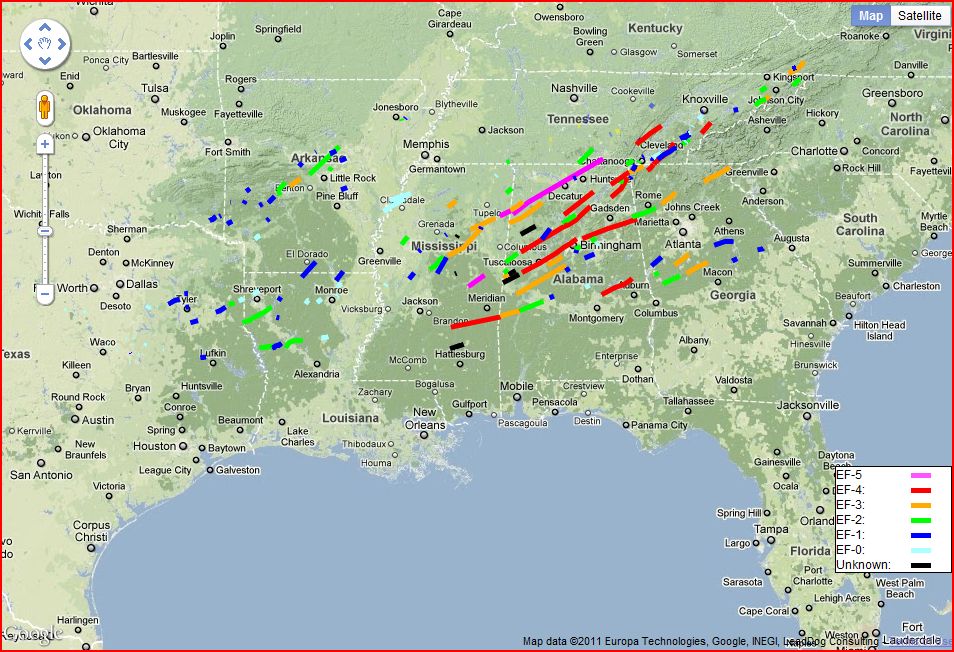
Images (click to enlarge): Preliminary April 25-28 tornado tracks as of May 6, pavement and turf gouging from the Neshoba County, Mississippi EF-5 tornado, from NWS

As the painstaking work of surveying the damage from the record tornado outbreak continues, the National Weather Service (NWS) announced this afternoon that a second Mississippi tornado on April 27 has been upgraded to EF-5 intensity. The new evaluation of the Neshoba/Noxubee County storm was based on analysis of extraordinary ground damage consistent with EF-5 strength winds: Large sections of sod and asphalt paving were literally ripped out of the ground.

This was the first EF-5 tornado in the area covered by the Jackson, Mississippi NWS office in over 40 years, since Feb. 21, 1971. Along with the previously identified Smithville EF-5, this was the first time since tornado records began that 2 EF-5 tornadoes have been observed in Mississippi on the same day. This also brings to 3 the number of EF-5 storms in the record outbreak of April 25-28, with about two-thirds of the storms surveyed so far.

The total number of confirmed tornadoes in the Jackson region now stands at 31, with
 4 EF-0
10 EF-1
11 EF-2
4 EF-3
1 EF-4
1 EF-5
The NWS reports:
IN TWO LOCATIONS...THE TORNADO ACTUALLY GOUGED OUT LARGE SECTIONS OF
THE GROUND. IN ONE SPOT IN NORTHEAST NESHOBA COUNTY...THE GROUND WAS
DUG OUT TO A DEPTH OF AROUND 2 FEET OVER AN AREA APPROXIMATELY 25-50
YARDS WIDE AND A COUPLE OF HUNDRED YARDS LONG. SIMILAR GOUGES...
ALTHOUGH NOT AS LONG OR DEEP...WERE ALSO OBSERVED IN EXTREME
NORTHWEST KEMPER COUNTY. WHILE THE EXACT MECHANISM THAT CAUSED THIS
DAMAGE IS UNCLEAR...INDICATIONS ARE THAT THIS TYPE OF GROUND DAMAGE
IS TYPICALLY ASSOCIATED WITH THE EXTREME WIND SPEEDS ASSOCIATED WITH
EF-5 TORNADOES.

IN THE AREA OF NORTHWEST KEMPER COUNTY WHERE THE GROUND GOUGING WAS
OBSERVED...THERE WAS ALSO AN AREA WHERE PAVEMENT WAS REMOVED FROM
THE GROUND. WHILE THIS TYPE OF DAMAGE CAN BE CAUSED BY TORNADOES OF
LESS THAN EF-5 INTENSITY...THE FACT THAT PIECES OF ASPHALT WERE
FOUND AT A SIGNIFICANT DISTANCE AWAY...BOTH UPWIND AND DOWNWIND OF
THE ROAD...ARGUES FOR EXTREME WIND SPEEDS. SIMILAR TYPE DAMAGE WAS
ALSO OBSERVED IN SOUTHWEST NOXUBEE COUNTY.

FINALLY...EXTREME VEHICLE DAMAGE OF THE TYPE NORMALLY ASSOCIATED
WITH EF-5 TORNADOES WAS OBSERVED. THIS INCLUDED NEW VEHICLES BEING
MOVED MORE THAN 100 YARDS FROM WHERE THEY STARTED...AND BEING LEFT
IN A NEARLY UNRECOGNIZABLE STATE.

Seasonal Outlook

Latest seasonal forecast: Click here.


Latest 3-month temperature outlook from Climate Prediction Center/NWS/NOAA.