Thursday, July 5, 2007

Weather Warms After Showers Subside

Now


Mostly cloudy, muggy, scattered showers. Following yesterday's storms which affected some parts of the area much more than others (see the rainfall map below), clouds and some showers have persisted today ahead of a cold front working its way southeastward through the Ohio Valley. National Airport, which eked out only 0.03" yesterday, picked up 0.11" in a heavy shower between 2pm and 3pm. Temperatures around the region are generally in the upper 70s with very humid dewpoints of 69-73°.

Scattered showers and some thunderstorms are likely through this evening as a line of storms now in southern Pennsylvania moves southeastward. Tomorrow, we clear things out and begin a warming trend. For the detailed outlook through the weekend and beyond, scroll on down to Josh's post below.

Rainfall Report


Where you stand on yesterday's storms depends on where you sit. While areas from southern Frederick Co. through Howard Co. and most of the immediate Baltimore metro area got nice soakings of ½" or more (shades of green), the amounts tailed off sharply to the south. Nearly all of the areas inside the DC Beltway got less than ¼" (lighter shades of blue), and there was virtually nothing south of Fairfax Co. in VA and central Prince George's Co. in MD.

Experimental precipitation map for 24 hr. ending 8am this morning from NWS

Bureaucratic Brouhaha


Considering that National Hurricane Center directors traditionally have come from within the ranks of the Center staff, the Proenza controversy (see "Havoc at the Hurricane Center" in Dan's post from yesterday) seems to be taking on at least some of the aspects of a bureaucratic food fight. Meanwhile, NOAA HQ is quoted as saying that the special assessment team currently evaluating the situation at NHC has nothing to do with Proenza's previous statements. Two Florida members of Congress, however, are questioning that assertion. Would you like an order of fries with that bridge you're buying, Admiral?

Wunderground hurricane blogger Jeff Masters weighed in last night with his opinion on Proenza's QuikSCAT satellite concerns. He concludes that "NHC official forecasts for landfalling storms in the Atlantic would not be significantly affected by the loss of the QuikSCAT satellite." On the other hand, Masters does strongly support Proenza's legitimate concerns regarding budgets for research in particular and the Hurricane Center overall, especially in light of NOAA's PR focus on brand identity and anniversary celebrations.

Mediarology: Earth Comes Alive on 07/07/07


The Weather Channel will be providing coverage of the Live Earth concerts on Saturday. Coverage begins with reports on "Abrams and Bettes" and "Evening Edition" Friday night and continues with live broadcasts from Giants Stadium on "Weekend View" Saturday morning (7-11am). "Forecast Earth" (Sunday 5-6pm) will take a broader look at Live Earth and the environmental issues it represents.

Widespread coverage is also scheduled on NBC and its affiliated networks. The NBC main network will have coverage from 8-11pm. Bravo will have coverage from 9am Saturday through 2:30am Sunday, Sundance will run from 4am Saturday through 2am Sunday, MSNBC will have periodic reports throughout the day, and CNBC will be on from 7pm Saturday through 2am Sunday. Some coverage will also be available on Telemundo and Univision.

Live streaming will be available on MSN. Radio broadcasting will be provided by both XM and Sirius.

Tuesday, July 3, 2007

Fine Fourth Foreseen
Some Storms Possible

Now


Variable clouds, warm. The center of the high pressure area which brought several days of cool, dry weather to the Washington metro area is moving offshore along the Virginia/North Carolina coast today, swinging the wind direction to the south and southwest. Humidity has increased somewhat along with the cloudiness. Dewpoints in the low to mid 50s mean it is still quite comfortable, however, especially with temperatures barely into the 80s.

Humidity will continue to increase, along with the chances of late day thunderstorms, to potentially dampen some Fourth of July activities.

Tonight and Tomorrow


Warm, more humid, chance of showers. Lows tonight under partly cloudy skies will be from the mid 60s downtown to the low 60s in the 'burbs. Tomorrow will be mostly sunny and more humid with highs 82-87° and a 30% chance of late afternoon or evening thunderstorms.

For the outlook through the rest of the week, scroll on down to Jason's post below.

Tropical Topics


The National Hurricane Center reports that a low pressure area about 1500 miles east of the Windward Islands has the potential to become a tropical depression in the next couple of days.

School Daze: Double Lives


The "two best things about being a teacher are July and August." This week's installment of the WaPo's "Secret Worlds of Summer" series describes the activities of teacher/lifeguards.

Accompanying that article is a story on what a Rockville science teacher did on his summer vacation. If you are a K-12 teacher and are interested in a more productive use for your summer, check out yesterday's Update for information on the NWA education fund grants program.

Have a great holiday!

Monday, July 2, 2007

DC: Dry, Cool

Now


Sunny, comfortable. June finished 1.6° above the long-term average, but a high pressure area centered over Michigan continues to pump unusually comfortable air for the season into the Washington metro region. At mid afternoon, temperatures were in the upper 70s and dewpoints were in the 40s, resulting in relative humidity as low as 26%. Northerly breezes were generally light, but some gusts were up to 20 mph.

Gradually increasing humidity tomorrow should lead to a somewhat muggy, but not hot, Fourth of July.

Tonight and Tomorrow


Partly cloudy, warm. A few clouds will develop overnight with lows near 60° downtown and in the 50s in the 'burbs. Tomorrow will be sunny and warm with a gradual increase in humidity and highs 80-84°.

For the outlook through the holiday and the rest of the week, scroll on down to Jason's post below.

School Daze: Attention K-12 Teachers!


The National Weather Association (NWA) is offering $500 Sol Hirsch Education Fund grants to K-12 teachers to help them improve their meteorology education programs. Applications, which are available through the NWA web site, are due by August 1. In reviewing past winners of the award, it appears that none of them has been from the Nation's Capital region. To help promote participation in this area, PM Update will match the NWA award with $100 of weather or climate books and/or videos from the CapitalWeather.com store for any winner from Maryland, DC, or Virginia. If you are a teacher from this area applying for the award, please let us know your name and school via email through the "Contact Us" link, and if you are selected, we will send you your choice of books or videos.

Snow News is Good News


It may be July, but the Beeb Weather Centre has a worldwide report on summer skiing conditions.

Mediarology


Beginning last night, it's "Viewers Favorites Week" on The Weather Channel's "Storm Stories" series at 7pm. Some of the episodes sheduled to be shown are: "Oklahoma Tornadoes", "Nebraska Weather Dog", and "Survival South Pole Cancer".

Thursday, June 28, 2007

Scattered Showers Still Somewhat Spotty

** Severe Thunderstorm Watch in Effect Until 11 PM **

Now


Warm, humid, scattered thunderstorms. Ahead of a cold front moving slowly but steadily southeastward from the Great Lakes, showers and storms have been fairly widely scattered across the Washington metro area this afternoon. National had a light thunderstorm early this afternoon, but total rainfall was a pitiful 0.02". The brief shower at Dulles was good for only 0.01". One or two more lines of storms are likely to bring rain and thunder to at least some parts of the metro area through the evening and possibly into the morning hours; a few storms could be severe. Cooler temperatures will arrive tomorrow in time for a more pleasant weekend.

Tonight and Tomorrow


Evening storms likely, gradually cooler and less humid. Showers and thunderstorms will be scattered through the region (60% chance at any given location) through this evening and possibly into the overnight hours. Otherwise, warm and humid conditions will continue for the rest of tonight with lows 69-75°. Considerable clouds and showers tomorrow morning could linger into the afternoon, though some clearing is possible by late afternoon. Highs will be 80-84° with gradually decreasing humidity.

For the outlook through the weekend and beyond with Larson's Long-Range, scroll on down to Josh's post below.

Rainfall Review


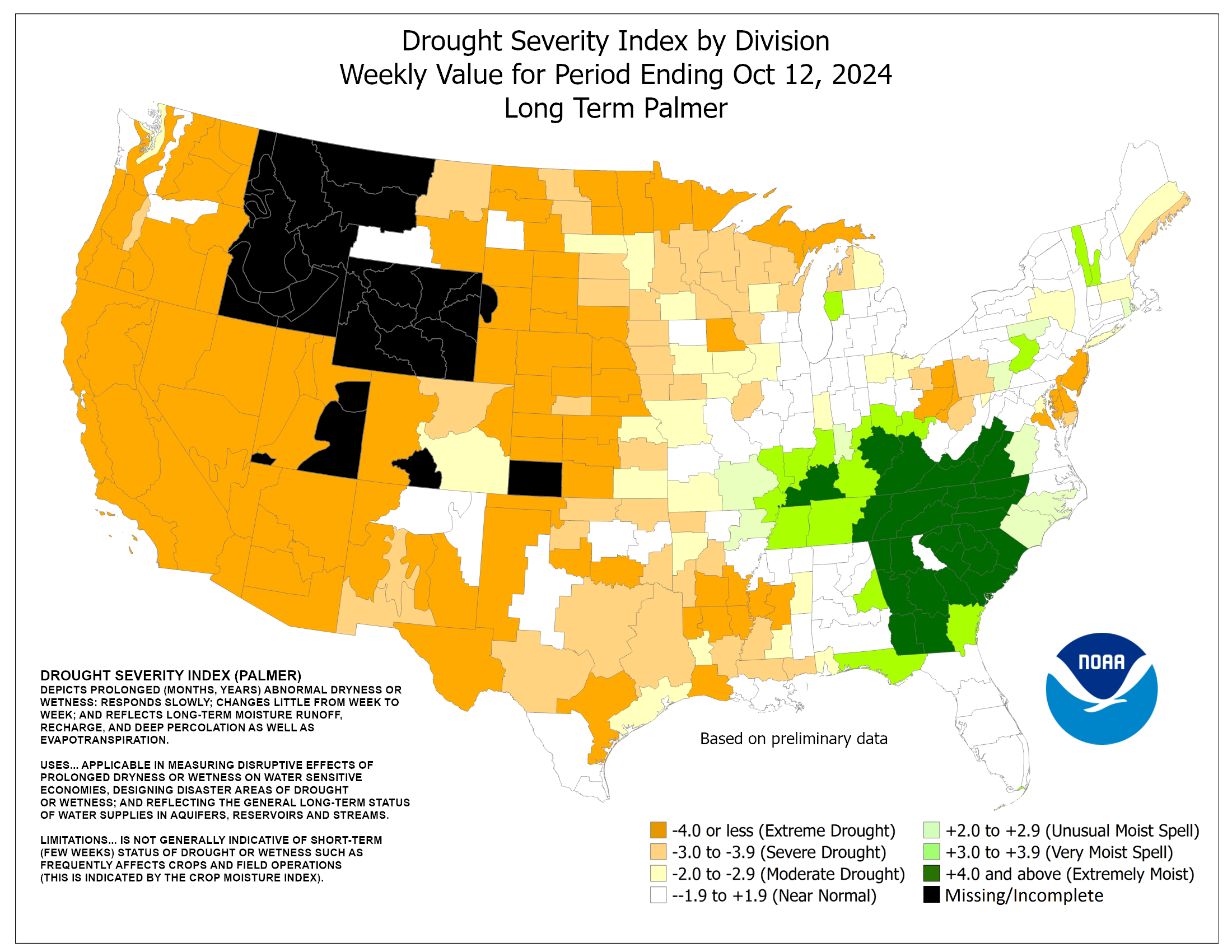
In marked contrast to exactly a year ago, when torrential rains caused a state of emergency to be declared, yesterday's showers were extremely spotty through the metro region. Even the small area of dark blue in western MoCo on the NWS precipitation analysis map to the right represents 0.5" or less. As has frequently been the case recently, areas from northeast of Baltimore to above the Mason-Dixon line have received much more generous amounts. In the latest weekly drought report, the metro region is in the Moderate Drought range on the Long Term Palmer Index.

Tropical Topics


A tropical wave is producing showers across the Bahamas and portions of Florida. Any development is expected to be slow as the system moves northwestward, but locally heavy rains are likely.

Wednesday, June 27, 2007

DC: DisComfort

Now


Partly sunny, warm, muggy, some storms. It's another muggy afternoon in the Washington metro area with some popup thunderstorms already appearing earlier. After reaching at least 93° by 1pm, National's temperature retreated to 82° the following hour in a very light thunderstorm, but Dulles surged ahead to 95° by mid afternoon. To the south, traditionally warm Fredericksburg combined a dewpoint of 75° with a temperature of 99° to get a sweat-soaked heat index of 111.

At post time, the only warnings in effect were marine warnings for Chesapeake Bay and severe thunderstorm warnings in south-central and southwestern Virginia. No watches were posted. Here at Update Central in west-central MoCo, a slight rumble of thunder has just begun. After another day of discomfort, more pleasant conditions are in prospect for the upcoming weekend.

Tonight and Tomorrow


Chance of evening storms, continued muggy. Showers and thunderstorms will be scattered across the region (30% chance at any given location) through this evening. For the rest of tonight, warm and humid conditions will continue with lows in the mid 70s downtown and the low 70s in the 'burbs. Tomorrow will be hot and humid with highs generally 90-94° and thunderstorms likely, some possibly severe, in the afternoon and evening.

For the outlook through the rest of the week and the weekend, scroll on down to Dan's post below.

Climate Corner


If you're confused (or just curious) about some of the claims that have been made regarding the atmospheric thermodynamic effects of increasing CO2, check out the latest post at RealClimate.org by Spencer Weaert, called "A Saturated Gassy Argument".

The Weather Channel's Forecast Earth blog had a post yesterday by our own Andrew Freedman on the Emily Yoffe WaPo op-ed cited earlier by Dan.

Drought Watch


A June 22 article in The Week magazine, "Desperate for Water", surveys the effects of long-term drought in the western U.S.

Monday, June 25, 2007

Some Say "Sultry," Many Mutter "Muggy"

Now


Mostly sunny, warm, muggy. Whether you call it "sultry," "muggy," or "yucky," classic DC heat and humidity are back in the Washington metro area: temperatures mainly in the upper 80s, dewpoints pushing into the 70s. Late this afternoon, Culpeper's readings of 90° (temperature) and 72° (dewpoint) produced a heat index of 97, while a southerly river breeze kept the National Airport official temperature and dewpoint to 87° and 69°, respectively, for a more bearable heat index of 91.

After several days of discomfort, more pleasant conditions are predicted for next weekend.

Tonight and Tomorrow


Chance of evening storms, continued muggy. There is a 30% chance of scattered thunderstorms through this evening, mainly to the south and west of the immediate metro area. Warm and muggy conditions will prevail overnight with lows from the low 70s downtown to some upper 60s in the 'burbs. Tomorrow will be hazy, warm, and humid with a 25% chance of afternoon or evening thundershowers and highs 89-93°, heat indices reaching the mid or upper 90s.

For the outlook through the rest of the week, scroll on down to Jason's post below.

Tropical Topics


The UK Met Office last week issued a hurricane season forecast which is considerably tamer than those issued earlier by NOAA and Colorado State. The UK forecast, which is being issued publicly for the first time, uses a dynamical (physical) model of the ocean/atmosphere system, called GloSea, as opposed to the mainly statistical techniques used in other forecasts. The prediction calls for 10 named storms in the July-November period, slightly less than the recent historical average of 12.4.

Climate Corner


In an exclusive report, The Onion last week detailed the Bush Administration's latest climate change program, the NACI (National Air Conditioner Initiative). Bush is quoted as saying,
"Global warming threatens us all, whether we're mowing our lawns, rafting down a river in a national park, or driving to the end of the driveway to get our mail. The task that lies ahead is undeniably hard. But if we do not succeed, we will be profoundly inconvenienced. And I promise you: America will not let that happen."
Graphic courtesy The Onion.

Thursday, June 21, 2007

Superb Solstice, But Some Storms Possible

** Severe Thunderstorm Watch in Effect Until 10 PM **

Now


Mostly sunny, warm. Clouds drifting southward this afternoon from some fairly heavy thunderstorm activity in Pennsylvania ahead of a cold front have marred what was otherwise a crystal-clear blue sky in the Washington metro area. In fact, these storms, which have already prompted a severe thunderstorm warning for Washington County, MD, appear to have the momentum to at least graze the northern suburbs by evening.

Otherwise, mid afternoon temperatures in the range of 86-88° and dewpoints as low as 50° have combined for a very comfortable summer solstice.

CapitalWeather.com chart from NWS data, photo © Kevin Ambrose

Tonight and Tomorrow


Chance of evening storms, but mainly comfortable. There is a chance of showers or thunderstorms through this evening, especially north of the Beltway. The remainder of tonight will be partly cloudy with comfortable humidity and lows in the low to mid 60s in the city and some upper 50s in the 'burbs. Tomorrow will be sunny, dry, and a little cooler with highs 81-84°.

For the outlook through the weekend and beyond with Larson's Long-Range, scroll on down to Josh's post below.

Blogrolling


CapitalWeather.com's Andrew Freedman had a post on Monday at The Weather Channel's Forecast Earth blog reviewing temperature and precipitation anomalies (departures from average) through May of this year.

Seasonal Outlook

Latest seasonal forecast: Click here.


Latest 3-month temperature outlook from Climate Prediction Center/NWS/NOAA.