The Washington DC metro area has a 33rd official 90-degree day after an overnight low which dropped only to 67. A bright September sun through mostly clear skies and a brisk westerly breeze bringing downslope warming ahead of an approaching cold front have produced this above-average warmth. Reflecting the relatively low humidity, the radar is clear for hundreds of miles in each direction.
Outlook
Tonight, the passage of the cold front should allow temperatures to drop a few degrees below last night: mid 60s in town, and low 60s in the 'burbs. Tomorrow will be warm and dry, highs in the mid 80s. Scroll down for Jason's full weekend forecast and tune in each morning for event updates. Have a great holiday!
Tropical Topics
This year's hectic hurricane season continues apace. (I've always wanted to use that word.) Former Storm Lee continues to be depressed in the central Atlantic, and advisories were discontinued at 11pm last night unless regeneration occurs.
Tropical Storm Maria developed from T.D. 14 this morning. Fortunately for the recovery efforts from the Katrina Catastrophe, this storm is no threat to land. It is projected to move northwestward east of Bermuda next week.
In the 55 years since storms began having names, there have been only 9 years with an "M" storm, and the only other one as early as September was Marilyn, on 9/12/1995. Even in the record-breaking year of 1933, what would have been the "M" storm occurred on September 8.
More Thoughts on Katrina
As some readers are fond of reminding us, this is a DC weather blog, and strictly speaking, Katrina was not a DC weather event. DC is where environmental policies are formulated and funded, however, and the extent of the tragedy is relevant whether we have direct personal connections to the Gulf Coast or not. A front page article"Planning, Response Are Faulted" and an editorial"From Bad to Worse" in today's WaPo address questions which had already been raised in Capitalweather posts and comments as early as before storm landfall. New Orleans mayor Nagin has been widely quoted strongly expressing his opinion.
It's extremely important to have this discussion now, even as people are still being rescued and bodies are being recovered. That's because long, sad history proves that it's impossible to engage the public on a problem until a crisis actually occurs. The problem with the environmental crisis that we face is that it is mostly gradual in its effects. There have already been "canaries" dying in the coal mine, but this is one 800-pound gorilla. Someone said on NPR, I can't recall who, that the real test of a society is not how it reacts to a crisis at the time, but how it deals with the lessons afterward. We have to decide as a country and as members of a larger world community whether we have the will to set the necessary priorities to have a sustainable civilization, or whether the purpose of life is simply to consume resources at the maximum possible rate. Should we cut $70 million from hurricane protection for New Orleans, but spend $223 million for a bridge in Alaska to an island with 50 residents? That kind of action, although carried out in the genteel halls of Congress, is simply looting without a shopping bag.
There are many questions which need to be addressed in this particular situation, not the least of which is, should we make a huge investment, only to restore New Orleans to its previous level of risk? Asking these questions is not partisanship, it is humanitarianism. Partisanship is putting ideology above science, expertise, and professionalism. Partisanship is substituting photo ops for action. For the record, in case anyone is not aware, although the national administration is obviously Republican, both the state and local administrations in New Orleans are Democratic. There is clearly plenty of responsibility to go around. Our responsibility, as scientists and educated members of the concerned public, is to keep asking the questions. For too long, the discussions have been carried out in the polite forums of academic debate, where they can be conveniently ignored by those who have a vested interest in business as usual. The results are in: The policy of business as usual is bankrupt, and it must be replaced.
Your constructive comments are welcome.
Friday, September 2, 2005
Thursday, September 1, 2005
Quick Update
- Official temperature reached 87 at 4:00; 90 is possible tomorrow, but with decent humidity. Turn off your air conditioning tonight for lows in the 60s!
- Holiday weekend continues to look great.
- Lee regressed to a depression, moving north well east of Bermuda.
- T.D. 14 formed this morning in the central Atlantic, expected to move east of Bermuda early next week.
- NPR has more Katrina resource links
Wednesday, August 31, 2005
Hurricane Party Over, but Hangover Persists
5:15 update: T.D. 13 is now Tropical Storm Lee, but is still no threat to land.
After a very sultry night, dewpoints in the upper 60s and a strong breeze gusting over 25 mph at times have made today more comfortable in the Washington DC metro area. Last night's low of 80 will undoubtedly be eclipsed before midnight, but if it were to hold, it would make today's minimum the warmest of the summer. Despite some ominous-looking clouds swirling around the large circulation from the remnants of Katrina, the nearest precipitation to the Washington area is widely scattered across Pennsylvania.
Outlook
Clouds, winds, and humidity will all decrease overnight, with lows by morning in the upper 60s to around 70. Tomorrow will kick off the first day of meteorological fall with partly cloudy skies, lower humidity, and warm temperatures, highs in the mid 80s.
Tropical Topics
The remnants of Katrina are still being tracked for flood potential as they merge into an extratropical low pressure area to the northeast. Maximum precipitation this morning was near the U.S.-Canadian border in New York state.
Tropical Depression 13 has regenerated between Bermuda and the Azores. It is no threat to land as it moves northeast.
The low pressure area which is now about 1300 miles east of the Lesser Antilles is well organized and shows potential for development as it moves northwest in the next couple of days.
Katrina Kuestions
The history of the master disaster called Katrina is far from being written, but it's not too early to start asking what lessons can be learned from the experience. The first question to be asked, and the most objective to answer, is:
How good was the science?
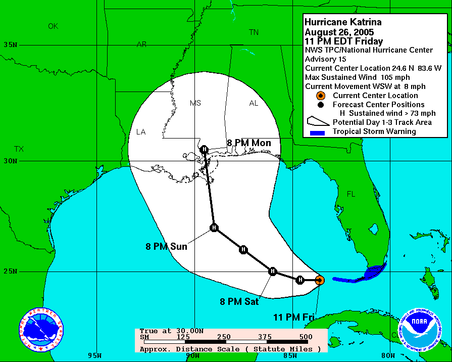
Answer: In a word, outstanding. Director Max Mayfield and his crew at the National Hurricane Center can be justifiably proud of the accuracy of their forecasts. The forecast track issued 11pm Friday, about 60 hours before Gulf landfall, had an error of about 15 nautical miles. (The full sequence of forecast tracks is available here).
The second question is:
How good was the emergency preparation?
This one will certainly be hotly debated, but my opinion so far is, not so good. Given the clear threat to New Orleans as early as Friday night and the long lead time required for an effective evacuation, why was the evacuation order delayed until nearly noon on Sunday?
There are a whole series of additional questions related to the effectiveness of the response which are still to be resolved and which we don't have time to cover today. Ultimately, however, they boil down to: Which is more effective, listening to the science and putting plans in place, with adequate funding, to deal with the inevitable, or buzzing the ruins in a 747 with a look of studied concern and offering prayers for the certainly hundreds, probably thousands, of casualties?
After a very sultry night, dewpoints in the upper 60s and a strong breeze gusting over 25 mph at times have made today more comfortable in the Washington DC metro area. Last night's low of 80 will undoubtedly be eclipsed before midnight, but if it were to hold, it would make today's minimum the warmest of the summer. Despite some ominous-looking clouds swirling around the large circulation from the remnants of Katrina, the nearest precipitation to the Washington area is widely scattered across Pennsylvania.
Outlook
Clouds, winds, and humidity will all decrease overnight, with lows by morning in the upper 60s to around 70. Tomorrow will kick off the first day of meteorological fall with partly cloudy skies, lower humidity, and warm temperatures, highs in the mid 80s.
Tropical Topics
The remnants of Katrina are still being tracked for flood potential as they merge into an extratropical low pressure area to the northeast. Maximum precipitation this morning was near the U.S.-Canadian border in New York state.
Tropical Depression 13 has regenerated between Bermuda and the Azores. It is no threat to land as it moves northeast.
The low pressure area which is now about 1300 miles east of the Lesser Antilles is well organized and shows potential for development as it moves northwest in the next couple of days.
Katrina Kuestions
The history of the master disaster called Katrina is far from being written, but it's not too early to start asking what lessons can be learned from the experience. The first question to be asked, and the most objective to answer, is:
How good was the science?
Answer: In a word, outstanding. Director Max Mayfield and his crew at the National Hurricane Center can be justifiably proud of the accuracy of their forecasts. The forecast track issued 11pm Friday, about 60 hours before Gulf landfall, had an error of about 15 nautical miles. (The full sequence of forecast tracks is available here).
The second question is:
How good was the emergency preparation?
This one will certainly be hotly debated, but my opinion so far is, not so good. Given the clear threat to New Orleans as early as Friday night and the long lead time required for an effective evacuation, why was the evacuation order delayed until nearly noon on Sunday?
There are a whole series of additional questions related to the effectiveness of the response which are still to be resolved and which we don't have time to cover today. Ultimately, however, they boil down to: Which is more effective, listening to the science and putting plans in place, with adequate funding, to deal with the inevitable, or buzzing the ruins in a 747 with a look of studied concern and offering prayers for the certainly hundreds, probably thousands, of casualties?
Tuesday, August 30, 2005
The Day After
TORNADO WATCH IN EFFECT UNTIL MIDNIGHT
LinkRain from the remnants of Katrina is concentrated in the Ohio Valley this afternoon, but there is a threat that showers and thunderstorms could develop in the Washington DC metro area. Temperatures at mid-afternoon are generally in the mid 80s and dewpoints are very humid, mainly in the mid to upper 70s. Radar shows showers scattered from West Virginia into western Virginia to near Charlottesville and Roanoke. Showers are also found on the Delmarva peninsula, mainly in Delaware, where some are moderate to heavy.
Outlook
There is a 70% chance of showers of showers or thunderstorms, some possibly severe, through tonight. Lows overnight will be in the low to mid 70s. Tomorrow will be partly cloudy, warm, and humid with a 30% chance of showers or thunderstorms. Highs will be in the upper 80s.
Tropical Topics
Katrina was downgraded to a tropical depression and advisories were discontinued at 11 this morning. Damage reports from New Orleans through the Mississippi and Alabama Gulf coasts continue to come in, and they are truly devastating.
Lost in the attention to Katrina was Tropical Depression 13, which formed Sunday afternoon east of the Lesser Antilles with winds of 30 mph. It dissipated yesterday morning, and advisories have been discontinued unless it redevelops. The remnants are disorganized, but the area is still being monitored.
An area of low pressure about 1500 miles east of the Lesser Antilles has unfavorable conditions for development, but the environment may become more favorable in the next day or so.
Katrina Resources
Our thoughts and prayers go out to the victims of Hurricane Katrina and to their relatives and friends in the DC area. Since this is a DC weather site, we will not be focusing on the details of storm damage and recovery, but here are some resources for keeping up with the latest developments. (Please also feel free to use our Comments section to discuss this truly historic storm.)
- Times-Picayune news blog
- AP News Wire via nola.com
- Biloxi Sun-Herald
- Miami Herald hurricane news
- WWLTV (CBS)
- WDSU (NBC)
- WGNO (ABC)
Monday, August 29, 2005
The Big Queasy
August 23, 2015 update
Links have been updated wherever possible to access archived versions of original news reports.
8:00 PM update
Katrina is a tropical storm as of 8pm EDT, maximum sustained winds 65 mph, but "strong winds and heavy rains remain a threat." It is now moving east of north at a faster rate, 21 mph. This track should put it into west-central Tennessee early tomorrow. The Times-Picayune reports ["Nothing but rooftops"] late this afternoon, "For miles in the 9th Ward, there were only rooftops, with floodwaters lapping at the eaves, visible from I-10. Rows of homes were swallowed by water."
5:30 PM update
The 5pm EDT advisory has Katrina as a minimal hurricane, maximum sustained winds 75 mph, moving north through Mississippi. Catastrophic damage ["Catastrophic power failure
Monday 2:10 p.m."] to New Orleans' entire electrical system is expected to take over a month to repair.
 4:30 PM update
For something lighter, check out Wonkette for what a man on the street in New Orleans told Fox News.
3:30 PM update
"Thousands of homes swamped, I-10 blocked as Katrina pummels region": Team coverage from the Miami Herald summarizes the current state of damage reports.
3:00 PM update
As of 3pm EDT, Katrina is a Category 1 storm, maximum sustained winds 95 mph, moving due north 20 miles from Hattiesburg, MS. Serious flooding is reported in the New Orleans area.
1:00 PM update
Katrina has been downgraded to Category 2, maximum sustained winds 105 mph, still moving north 40 miles SSW of Hattiesburg, MS. Jim Cantore of the Weather Channel reports 10 feet of water surrounding his location in Gulfport, first floor flooded. Most of downtown Mobile is flooded, according to CNN.
Noon update
The eye of Hurricane Katrina has now made final landfall between Slidell, LA and Bay St. Louis, MS. The strongest winds are in Mississippi. Widespread phone as well as power outages are reported in New Orleans.
In case you think the storm doesn't affect you directly in the Washington DC area, CNBC reports that oil prices are up over $2 a barrel to around $68.50 after being over $70 overnight in Asia. Natural gas prices are up 18% for the day on the futures contract which expires today.
11:00 AM update
The 11:00 EDT advisory from the National Hurricane Center puts the center 35 miles ENE of New Orleans, moving N at 16 mph, max winds 125 mph, min pressure 927 mb. Jim Cantore's producer reports from Gulfport by phone that their rental cars and satellite truck have been flooded by storm surge, 27 feet above sea level, and water is coming in to the first floor of the building where they are staying. Biloxi, to the east, is reporting wind gusts to 78 kt.
10:30 AM update
 The eye of Hurricane Katrina is passing just east of the city of New Orleans. The latest official report, at 9am EDT, put the center about 40 miles southeast of the city, moving north at 15 mph, maximum sustained winds 135 mph. Cable news channels are showing daylight through some rips in the fabric covering of the Superdome, allowing rain to fall inside. The Times-Picayune online reports from a morning emergency services teleconference:
Links have been updated wherever possible to access archived versions of original news reports.
8:00 PM update
Katrina is a tropical storm as of 8pm EDT, maximum sustained winds 65 mph, but "strong winds and heavy rains remain a threat." It is now moving east of north at a faster rate, 21 mph. This track should put it into west-central Tennessee early tomorrow. The Times-Picayune reports ["Nothing but rooftops"] late this afternoon, "For miles in the 9th Ward, there were only rooftops, with floodwaters lapping at the eaves, visible from I-10. Rows of homes were swallowed by water."
5:30 PM update
The 5pm EDT advisory has Katrina as a minimal hurricane, maximum sustained winds 75 mph, moving north through Mississippi. Catastrophic damage ["Catastrophic power failure
Monday 2:10 p.m."] to New Orleans' entire electrical system is expected to take over a month to repair.

For something lighter, check out Wonkette for what a man on the street in New Orleans told Fox News.
3:30 PM update
"Thousands of homes swamped, I-10 blocked as Katrina pummels region": Team coverage from the Miami Herald summarizes the current state of damage reports.
3:00 PM update
As of 3pm EDT, Katrina is a Category 1 storm, maximum sustained winds 95 mph, moving due north 20 miles from Hattiesburg, MS. Serious flooding is reported in the New Orleans area.
1:00 PM update
Katrina has been downgraded to Category 2, maximum sustained winds 105 mph, still moving north 40 miles SSW of Hattiesburg, MS. Jim Cantore of the Weather Channel reports 10 feet of water surrounding his location in Gulfport, first floor flooded. Most of downtown Mobile is flooded, according to CNN.
Noon update
The eye of Hurricane Katrina has now made final landfall between Slidell, LA and Bay St. Louis, MS. The strongest winds are in Mississippi. Widespread phone as well as power outages are reported in New Orleans.
In case you think the storm doesn't affect you directly in the Washington DC area, CNBC reports that oil prices are up over $2 a barrel to around $68.50 after being over $70 overnight in Asia. Natural gas prices are up 18% for the day on the futures contract which expires today.
11:00 AM update
The 11:00 EDT advisory from the National Hurricane Center puts the center 35 miles ENE of New Orleans, moving N at 16 mph, max winds 125 mph, min pressure 927 mb. Jim Cantore's producer reports from Gulfport by phone that their rental cars and satellite truck have been flooded by storm surge, 27 feet above sea level, and water is coming in to the first floor of the building where they are staying. Biloxi, to the east, is reporting wind gusts to 78 kt.
10:30 AM update

In New Orleans, water topped a levee along the Industrial Canal. The city's 911 emergency system was out of service and Charity Hospital was on emergency power and windows had been blown out on five floors. . . . And a 20-foot tidal surge knocked out four pumping stations; only one was able to get back into service.We will keep you posted through the day as conditions warrant.
Subscribe to:
Posts (Atom)
Seasonal Outlook
Latest seasonal forecast: Click here.

Latest 3-month temperature outlook from Climate Prediction Center/NWS/NOAA.
Latest 3-month temperature outlook from Climate Prediction Center/NWS/NOAA.


