
 The latest U.S. Drought Monitor report, issued yesterday for data through July 3, shows that the total area of the 48 contiguous states in some level of drought (over 76%) is the largest since at least 2000. While Tropical Storm Debby virtually wiped out drought in Florida, much of the Southeast remains in drought, with over one-third of Georgia in Extreme or Exceptional drought (D3-D4). Other than Florida, the least droughty areas are generally in the corners: the Pacific Northwest, northern Great Lakes, and Northeast from Pennsylvania through New England.
From the Drought Monitor report:
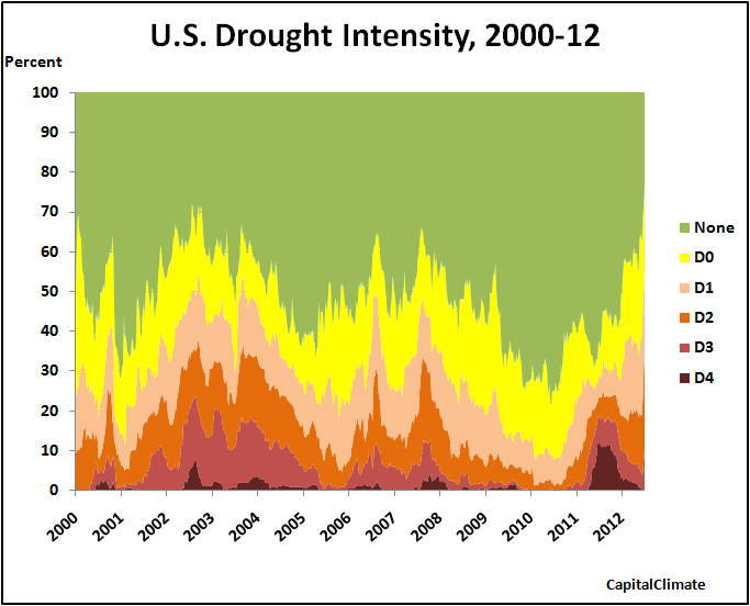
Overall, this week featured the expansion and intensification of dryness in large sections of the country, with only southern Texas reporting some improvement. Light precipitation (0.5 inch or less) fell on most areas of dryness and drought, with only scattered areas reporting more than an inch, primarily in the northern Plains, lower Mississippi Valley, southernmost Great Lakes region, Appalachians, mid-Atlantic region, and southern Texas. This despite a couple of thunderstorm complexes that pushed rapidly from northern Illinois east-southeastward through the mid-Atlantic, including one on June 29 that caused significant damage, knocked out power for millions of customers, and took 2 dozen lives. Unfortunately, where rain did fall (outside southern Texas), it was not enough to make up for blistering heat that covered the Nation’s midsection, reaching the central and southern Atlantic Coast by the end of the workweek. Both the number of record highs in the past week, and the areas with record and near-record dryness over the last 1 to 3 months, are too numerous to mention. Daily high temperatures averaged above 100 degrees in the central and upper southern Plains, extending eastward into parts of Missouri and Arkansas, and average temperatures for the week were 8 to locally 15 degrees above normal from the Ohio Valley and upper Southeast westward through most of the High Plains. The dryness is beginning to take a significant toll on some of the Nation’s crops, pastures, and rangelands. In the primary growing states for corn and soybeans (18 each), 22 percent of the crop is in poor or very poor condition, as are 43 percent of the Nation’s pastures and rangelands and 24 percent of the sorghum crop. In addition, the area scorched by wildfires expanded significantly. Over 1.9 million acres have been engulfed since the start of the year, and increase of 38 percent in just the past week.Images (click to enlarge): U.S. percentage area of drought, weekly from January 4, 2000 through July 3, 2012 (top) and January 4, 2011 through July 3, 2012 (middle), CapitalClimate charts from U.S. Drought Monitor data; U.S. Drought Monitor map for July 3, 2012


No comments:
Post a Comment