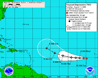
 The second tropical depression of the season formed in the Atlantic early this morning near the Cape Verde Islands. As of 11 am EDT, maximum winds were near 30 mph with some higher gusts. The depression was moving west at 13 mph, and this track is expected to continue for the next couple of days. Some slow strengthening is predicted, and the depression has the potential to become Tropical Storm Ana. However, sea surface temperatures along the track are only marginally warm, and there is drier air in the middle levels of the atmosphere. On the other hand, vertical wind shear is expected to be light for the next several days, which should encourage strengthening.
 Image (click to enlarge): Tropical Depression 2 forecast track from National Hurricane Center


No comments:
Post a Comment