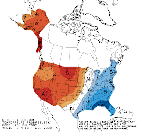


 Today's extended forecasts from the Climate Prediction Center continue to indicate cool and dry weather on average for the week leading up to and including Inauguration Day. January 20 is now included in the 6-10 day forecast, which calls for a 40-50% chance of below-average temperatures Jan. 16-20. In the longer range, the prediction for the 8-14 day interval Jan. 18-24 has the Mid Atlantic region well within a 50%+ area of below-average temperatures.
For precipitation, the shorter-range forecast (Jan. 16-20, not shown) has near equal chances of above, near, or below-average precipitation. The longer range (Jan. 18-24) has at least a 40% probability of below-average precipitation.
The individual 10-day model forecast for January 20 (read the caveats!) shows a warming trend following a strong cold outbreak in preceding days.
Today's temperatures (preliminary):
High 40
Low 32
Departure from average: +1
Month to date: +1.0
Precipitation:
Today 0.06"
Month to date 1.84"
Departure from average +0.80"
Days with measurable accumulation: 3 out of 10
Click here for all Inauguration Weather posts.
Images (click to enlarge): 6-10 day temperature, 8-14 day temperature, and 8-14 day precipitation forecasts from Climate Prediction Center/National Weather Service/NOAA; GFS model output map for sea level pressure, 1000-500 mb thickness, and precipitation, 7 am, January 20, 2009, from NCEP/NWS/NOAA
No comments:
Post a Comment